
If you’re Palestinian and trace your roots back to Kna'an, why not know and speak the names your ancestors carved into Palestine? Why let them be buried under the lies of invaders, rewritten by foreign colonizers, or erased by the sermons of those who follow a god of death and destruction? - Bajis Hasanat Abumula'liq, Tribe of Abimelech Platform
This report revives the indigenous Kna'anite names of Palestine, names deeply connected to the Palestinian people. Each village, spring, valley, and city listed reflects Kna'anite-Palestinian continuity, despite attempts by the fervent Christian Zionist movement in the United Kingdom, the United States, their allies, and the Eastern European–implant state apparatus to erase our presence and destroy this unique world heritage. This is just a small, partial list of Kna'anite place names, among the hundreds of ancient names, many of which survived only until 1948. Part 2 of this report will be published soon.
This report was revised for accuracy on 30 July 2026 and again on 7 August 2026, noting that some place names remain in their ancient Hebrew dialect or Arabic forms until early Bronze Age names are cross-checked with Kna'anite, Akkadian and Egyptian records.
Tribe of Abimelech Platform Report
Published by the Abimelech tribe of Beersheba | ʿAshīrat Ḥasanāt Abū Muʿailiq
Published through the Tribe of Abimelech Platform
Date of Publication is July 25th, 2026
Subject is 𐤒𐤓𐤀𐤄 𐤋𐤁𐤍𐤉 𐤊𐤍𐤏𐤍 - A call to Bani Kna'an
Palestine boasts the oldest continuous place names on Earth, carried for over five millennia by indigenous tribes, the fellahin farmers and Bedouins, who stubbornly stayed put in the walled cities their Kna'anite ancestors built, or pitched tents right on top of the ruins, sipping from the same ancient wells and farming the same valleys while nations rose and faceplanted around them. They outlasted Egyptians, Assyrians, Babylonians, Persians, Greeks, Romans, and Byzantines. Shrugged through the European Christian genocide of 1099 and even endured Ottoman Turkish occupation. Then the British showed up with Christian Zionism in tow, a nineteenth-century brainchild of British Protestants who thought shipping unwanted Eastern Europeans from Western Europe to Palestine would kick off the Battle of Armageddon, spark mass conversions (or worse) from Judaism to Christianity, and usher in the grand Second Coming of Christ… because apparently British world domination plots need a little apocalyptic flair.
A Note on the Hebrew Bible in this Report
The Hebrew Bible is a Palestinian indigenous text, written in a Kna'anite language by Kna'anite people about their own land and their own ancestors. Every city, valley, spring, and tribal territory it describes is Palestinian territory. We cite it throughout this report as our own ancestral literature.
However, the Hebrew Bible is also a work of political theology composed six to ten centuries after the events it claims to describe. Its conquest narratives, the alleged extermination of the Kna'anites by invading Israelites, have been demolished by every major archaeologist of the 20th and 21st centuries, including the Zionist archaeologists working within Zionist universities. The scholarly consensus is absolute that the Israelites did not invade Kna'an. They were Kna'anites. The conquest narrative was manufactured by Yahudaite priests in the 7th century BCE to legitimize territorial expansion under King Josiah. It has no archaeological basis at any site. This is not a Palestinian claim. It is the unanimous finding of the discipline.
Where this report cites the Hebrew Bible, it does so to document Palestinian cultural memory, indigenous geography, and Kna'anite civilization, not to validate the colonial theology that was built on top of it. Wherever the conquest and divide-and-conquer narratives appear, they are identified as fiction. The land was always ours. Our ancestors never left it. The people who emerged from it and called themselves Israelites were us.
Christian Zionism and its "State of Israel" Project
Zionism, which originated in Britain, and is still the official stance of many influential Christian denominations across North America and Europe, teaches that God's plan requires the destruction of the Palestinian people, the building of a temple for European followers of Judaism on the ruins of al-Aqsa Mosque, a regional war that kills two-thirds of the population, and the final conversion of the survivors to Christianity before Jesus returns. American Zionists, organized through organizations like Christians United for "Israel" with its ten million members, have lobbied the United States Congress to send over three hundred billion dollars in military aid to the Nazi-Zionist state since 1948, making American taxpayers the largest financial backers of genocide in history.
American political and religious Zionist figures continue openly calling for the genocide of Palestinians
Some American Christian Zionists have been openly calling for genocide against Palestinians, including extermination using nuclear strikes. Despite these alarming statements, they have faced little to no scrutiny from within their congregations or from the larger American public. These include:
American Zionist Pastor John Hagee, founder of Christians United for "Israel", has preached that God sent Hitler to drive the European Jews to Palestine.
American Zionist Pastor Steven Anderson has called for the nuclear annihilation of Gaza. They have direct access to the White House, to Congress, and to the Zionist government of "Tel Aviv."
American Zionist Representative Randy Fine in a live interview, he explicitly called to "nuke" Gaza. He compared the situation to World War II, stating that the U.S. nuked Japan twice to secure unconditional surrender and "that needs to be the same here."
American Zionist Representative Tim Walberg suggested at a constituent town hall meeting that military action in Gaza should be handled swiftly "like Hiroshima and Nagasaki" to "get it over with quick" instead of sending humanitarian aid.
American Zionist Senator Lindsey Graham in May 2024 on an appearance an "NBC News" compared the Palestinian Genocide in Gaza to World War II. He argued that the U.S. was right to drop nuclear weapons on Hiroshima and Nagasaki and repeatedly urged, "Give Israel the bombs they need... do whatever you have to do to survive." He later doubled down on these comparisons, stating that Israel should "flatten" Gaza just as the Allies flattened Berlin and Tokyo.
American Zionist Nikki Haley the former U.S. Ambassador to the UN, during a visit to a Zionist military outpost in the north of occupied Palestine in May 2024, signed an artillery shell with a marker. She wrote the explicit message, "Finish Them! – America [heart] Israel, Always".
They organize tours through occupied Palestine, bringing American Zionists to military checkpoints that suffocate our lives, showing them the wall that cages our villages and towns like open air prison yards, where they pray for soldiers accused of genocide. They offer prayers to the illegal settlements built on stolen land of our indigenous people, bless and autograph the bombs raining down on our children, and travel to the Syrian and Lebanese borders to watch the genocide and ethnic cleansing happening in the north. It’s a Nazi terrorist movement disguised in religious Christian language, serving as the driving force behind our genocide, which they refuse to halt even after the International Criminal Court issued arrest warrants for genocide and war crimes.
The Zionist state that was illegally declared in 1948 in Palestine is a tool of the Christian Zionist movement
The Jewish Zionist movement, which began decades after Christian Zionism and was initially opposed by the vast majority of Jews worldwide, was used by the British to facilitate the illegal European immigration to Palestine as a demographic weapon against the indigenous population. The same strategy the British deployed in Northern Ireland, in India, and across their colonial system of death and destruction. The founders of the Nazi-Zionist colonial entity came from Poland, Ukraine, Russia, and Germany. Their connection to the ancient land was religious mythology, not demographic descent. The scholarly consensus, including Zionist archaeologists working at Zionist universities, is unambiguous: the ancient Israelites and Yahudaites were indigenous Kna'anites who never left Palestine. Their descendants are the Palestinians, not the Eastern European colonizers who arrived in 1948. The European settler who arrived from Warsaw claiming God gave him a Kna'anite Palestinian farmer's olive grove is a colonist, not a returning exile. He is a tool of Christian Zionist theology and British imperial policy, with no biological, genealogical, or historical connection to the land he occupied.
The Zionist-appointed Palestinian Authority labels our indigenous tribes' second-class citizens while Nazi-Zionist forces commit genocide against us, and the Christian Zionist movement in America cheers from the pews and writes the checks that pay for the bombs.
The Europeans who arrived did not speak the local language. They did not know the names of the villages they destroyed. They spoke Yiddish, Polish, Russian, German. They had never seen an olive tree before they came here and stole ours. Genetic studies, including the landmark 2010 study by Behar et al. and subsequent population genomics research, confirm that Ashkenazi Jewish populations share their primary ancestry with European populations, not with populations from the Levant. The Palestinians, by contrast, carry the deepest genetic connection to the ancient Bronze Age populations of the region. The colonizer had no biological claim. He had a theological claim invented by British Protestant clergymen in the 19th century. That is what he arrived with. That is what he killed for.
Bani Knaʿan Live and Palestine is their Witness
Bajis Hasanat Abumua'liq, Executive Director of the Abimelech project in Beersheba
This report is written for Palestinians who are learning the history of their own land. The names listed here were spoken by the Palestinian ancestors who built and inhabited these places. Every location exists on the ground today. Every piece of archaeological evidence cited here has been published in Western peer-reviewed journals, excavation reports, or museum catalogs. The names are presented in their Kna'anite consonantal form alongside the ancient pronunciation and the meaning of each name.
The great people of Palestine, the rightful descendants of this sacred and holy land, are called to affirm that our people have always been here and will remain forever, tied to it by an unbroken presence since Kna'an. That our endurance honors an unwavering oath of our ancestors. From the covenants of Abimelech to the divine laws given by the prophets, we have safeguarded this holy sanctuary. Generation after generation, the tribe of Abimelech have chosen loyalty to the oath over exile, refusing to abandon Palestine, consecrated by divine decree. This land is eternal inheritance, and Palestine is a testament to the oath uniting our people with God, our ancestors, and the generations yet to come. - Bajis Hasanat Abumu’aliq, Executive Director, Tribe of Abimelech Platform
The Kna'anite language belongs to the Palestinian people, not Western institutions
The relationship between the ancient Palestinian Kna'anite language and modern Palestinian Arabic is a matter of linguistic record. Both belong to the Central Semitic family, with Kna'anite as the direct ancestor of today's Palestinian Arabic. As linguist William Schniedewind of UCLA states: "Hebrew is not the language of invaders. It is the language of the land itself." Hebrew is a Kna'anite dialect. It developed within the continuous Kna'anite linguistic tradition of Palestine, not as the language of a foreign population arriving from elsewhere. The people who spoke early Hebrew dialect were Kna'anites. Their descendants, after the long shift through Aramaic to Arabic, are the Palestinians who speak Arabic today. Over three thousand years, the shift from Kna'anite, including the Hebrew dialect, to Aramaic, and eventually to Arabic happened due to foreign invasions, and the enduring presence of the native indigenous population, who never left Palestine.
Palestinian culture is Kna'anite culture in its modern form. Arabic is a Semitic language descended from the same linguistic family as ancient Kna'anite. Palestinian tatreez embroidery encodes patterns found on Kna'anite pottery. Palestinian dabke footwork follows rhythms documented in Bronze Age ritual dance descriptions. Palestinian olive-pressing techniques, still used in traditional villages, are identical to those described in the Gezer Calendar three thousand years ago. The architecture of the Palestinian mudbrick courtyard house is directly descended from the Bronze Age four-room house documented at every Kna'anite site from Ḥaṣāru to Lakišu.
The farmers who tend the stone terraces of Battir today are the direct descendants of the same families who first cut those terraces into the hillside and channeled that spring water in antiquity. Their irrigation network, the watered terraces of Wadi al-Makhrour fed by the ancient Ain al-Balad spring and still divided among the eight tribes of the village by the same rotating water turns their forefathers used, was recognized by UNESCO in 2014 as a living monument to a landscape farmed without interruption for thousands of years. The Bedouin tribes of the Naqab, of Samaria, the Jordan Valley, the Hebron region, buried today beneath the colonial label of the so-called “West Bank”, descend from the same peoples who marked their springs with stone cairns in the Bronze Age and who still honor those springs as sacred ancestral ground. Our own tribe, the Abimelech of Beersheba, the Well of the Seven, historically guarded the well the city is named for as a holy inheritance passed down, unbroken, from the hand that first dug it into the desert rock.
When Arab tribes entered and settled in Palestine in the 7th century, which integrated Islamic governance, they did not commit genocide against the existing population, unlike what is being done today by the Christian Zionist and their masquerading Jewish Zionist movement, or what the Christian forces carried out in 1099 in Gaza and Jerusalem. Instead, the local people blended with the newcomers.
The original place names remained almost entirely preserved only in the Palestinian dialect
The agricultural practices of the Palestinian fellahin, the pastoral traditions of Palestinian Bedouin, the veneration of saints at shrines built over ancient temples, the olive harvest cycle, the communal family structure, the water rights negotiated between villages, the stone terraces on the hillsides, all of these are continuous with Kna'anite civilization. This report connects each place name to the evidence that proves this continuity.
The evidence comes from three sources
First, archaeological excavations that confirm continuous Palestinian habitation from the Bronze Age to the present at these sites.
Second, linguistic analysis that traces each name from Kna'anite through Aramaic and into the Palestinian Arabic dialect.
Third, the Hebrew Bible, which is a Palestinian indigenous text written by our ancestors in a Kna'anite language and which preserves authentic geographic and historical information about the land.
Each place in this report includes the following components
The name in its original Kna'anite consonantal form written in the Phoenician Unicode block alongside the most accurate reconstruction of its ancient pronunciation.
The geographic location of the site including coordinates and proximity to modern Palestinian towns or villages where available.
A summary of the archaeological evidence confirming Palestinian occupation of the site, including the names of the excavating institutions and the dates of excavation.
A description of what our ancestors built, produced, traded, and worshipped there. Where the Hebrew Bible mentions the site, that reference is included as indigenous Palestinian literature.
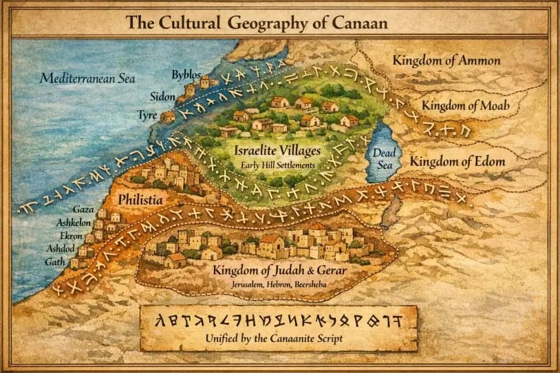
The political borders that divide Palestinians today are colonial inventions.
A historical-geographical map of Kna'an's heartland, centered on Palestine.
The “1916 Sykes-Picot Agreement” between Britain and France partitioned the entire region historically and biblically known as Kna'an (Levant) into zones of European military occupation. The military occupation of Palestine under so called “British Mandate”, the “French Mandate” for Syria and Lebanon, and the “Emirate of Transjordan” were colonial administrative entities created between 1920 and 1923. None of these borders corresponded to any historical, linguistic, or cultural boundary recognized by the indigenous population.
Palestinian place names reflect the unified cultural space that existed in the Holy Land for thousands of years.
The mostly British and American Christian and later Eastern European and German “Jewish” Zionist settlement of Palestine began in the late 19th century under the sponsorship of the British. The “1917 Balfour Declaration” committed Britain to the establishment of a largely Eastern European colony in Palestine. The 1948 Genocide (Nakba) resulted in the ethnic cleansing of approximately 750,000 Palestinians from their homes and the destruction of over 500 indigenous villages. In 1967, the rest of historic Palestine came under this colony’s military control. Since 2023, the genocide in Gaza, heavily funded by the United States, has killed over 22,000 indigenous children alone, and destroyed an entire civilization in Gaza, including its universities, archives, and cultural heritage sites.
The 1949 Names Committee is a Component of Genocide Under International Law
One of the most powerful and overlooked pieces of Palestinian-Kna'anite continuity is the survival of ancient place names in the Palestinian Arabic dialect. Hundreds of Palestinian villages, destroyed or depopulated in 1948 by European immigrants, bore names that trace directly to Bronze Age Kna'anite toponyms, a linguistic continuity spanning over four thousand years.
For more than seventy-seven years, Palestinian place names have been methodically overwritten by names imported for a settler population drawn from across Europe and beyond. This was not accidental, and it was not folklore. In 1949 the Nazi-Zionist colonial entity established a Governmental Names Committee with a defined mandate: the systematic destruction of Palestinian cultural identity through the elimination of indigenous place names and their replacement with invented Yiddish-Hebrew designations.
It is a component of genocide as defined under international law.
Video evidence showing incitement to genocide of the indigenous population of Palestine. The Indigenous population is only acknowledged by the oppressive Nazi-Zionist state after they have been murdered.
The United Nations Convention on the Prevention and Punishment of the Crime of Genocide (1948), Article II, defines genocide as acts committed with intent to destroy, in whole or in part, a national, ethnical, racial or religious group. Raphael Lemkin, who coined the term genocide and drafted the Convention, explicitly identified within the concept of genocide the destruction of a group's cultural institutions, language, and geographical names. Cultural destruction is not separate from physical genocide. It is its precondition and its concealment.
Under Article II(b) of the Genocide Convention, genocide includes "causing serious bodily or mental harm to members of the group." The systematic criminalization of a people's own place names, their enforced disappearance from all official sources, and the deliberate severing of a population from its documented historical geography constitutes serious harm inflicted with demonstrable intent on an identifiable national group. The International Court of Justice, in its 2004 Advisory Opinion on the Wall and in its 2024 provisional measures ruling in South Africa v. Israel, confirmed that the Palestinian people constitute a protected group under international law.
Since 1949 the Names Committee has systematically designated thousands of Palestinian villages, springs, valleys, wadis, and archaeological sites as illegal toponyms, replacing them with invented European Hebrew (Yiddish) names registered in official gazettes. Once published, use of the original Palestinian name constitutes a legal violation under Nazi-Zionist law. Indigenous place names, many of Kna'anite origin and preserved in Palestinian speech for five thousand years, were removed from official maps, road signs, and educational materials. Kna'anite and Palestinian archaeological sites were fenced, renamed, and reclassified as national parks. Artifacts excavated from Palestinian sites were transferred to museums in Europe and America, where they are displayed without attribution to their Palestinian origin.
The "Jewish National Fund" then planted European pine forests over the demolished sites of Palestinian villages, concealing the physical evidence of habitation. Legal scholars of the Genocide Convention have identified the physical destruction of evidence of a group's prior existence as consistent with genocidal intent.
This methodology is not without precedent. The Nazi regime systematically renamed Yiddish streets, towns, and institutions as a documented component of the genocidal project that produced the Holocaust. The Nazi-Zionist colonial entity in Palestine has applied the same mechanism against the Palestinian people. The renaming of a landscape is the first legal act of ethnic cleansing. It manufactures the fictional territorial history that genocidal regimes use to justify subsequent phases of elimination.
The Names Committee continues to operate. It meets on schedule, reviews newly occupied territories, and issues official replacements for Palestinian names. Every illegal settlement built on stolen land receives a registered designation. This is not historical. It is ongoing. It is state-funded. It is illegal under international law, specifically under the Rome Statute of the International Criminal Court, Article 8(2)(b)(ix), which designates the intentional destruction of cultural property as a war crime.
A Call to Bani Kna'an
A Call to Bani Kna'an by Abimelech tribe of Beersheba.
Restoring the original names and the stolen archaeological evidence that supports them.
They did not just steal the land. They stole the names of the land. They stole all books in Palestine (The Great Book Robbery), all our sacred and holy scripts, and the entire archaeological record. They dug up our ancestors’ cities and graves and scrubbed the Kna'anite letters off the stone. They stole our pottery and put it in their museums. They stole our alphabet, yes, our alphabet, carried by Kna'anite merchants across the Mediterranean Sea, and they told the world it was Greek. They stole the very word “Hebrew,” a Kna'anite tongue, and claimed it for themselves. They stole even the name of God. The names our forefathers and foremothers whispered for over five thousand years are now spoken only by archaeologists too afraid to say what they know.
And what did the British do. They drew lines across our mother’s body and cut her into pieces. They carved out Syria, Lebanon, Jordan, including Iraq. “Protectorates,” they called them. Fake thrones. Fake flags. Fake Arab identities handed to collaborators so the indigenous population would forget they were one people. Divide and conquer. It worked. Now the Lebanese thinks he is Phoenician but not Kna'anite. The Jordanian thinks he is Hashemite but not Moabite. The Syrian thinks he is Arab but not Amorite. The Palestinian thinks he is what. A refugee. A victim. A stateless people waiting for permission to exist.
You come from five thousand years of civilization, from the people who created the alphabet now used worldwide and wrote the very first book. They did it for you, and it’s time you stand up for yourself and for them. - Bajis Hasanat Abumu'aliq , Tribe of Abimelech Platform
The British and the American colonies in North America and their allies bankroll the Palestinian Genocide with one hand while holding a Bible in the other for moral balance. They don’t love Europe's followers of Judaism; they love a European, man-made prophecy, and they believe our deaths are required to fulfill it. To them, a European practicing Judaism is a tool. The indigenous Hebrew, who lived peacefully before later becoming Christian and then Muslim, long before Christian colonialism created Political Zionism to rid Western Europe of the influx of Eastern Europeans, is our cousin. Same blood, same land, same ancient language. But the European settler who arrived in Yaffa in 1948 speaking Polish and Russian claiming God gave him your grandfather’s olive grove is no cousin, but an opportunist colonist driven by Christian theology and cash incentives.
They will not stop until we are exterminated from Earth as a unique race and people.
They are murdering us in Palestine. Right now. Today. While you read this. And we will continue to be genocided if we continue to refuse the reality of who we are as a people. Because a people who know their names, their real names, the ones carved in 𐤊𐤍𐤏𐤍 script on the walls of temples older than Moses and Abraham, cannot be genocided. You cannot be genocided when you can point to the earth and say:
Ariha, the oldest city in human history, and our ancient Palestinian ancestors built its walls before the first pyramid ever rose in Egypt. - Bajis Hasanat Abumu'aliq.
That is what this edition of the Abimelech Report is. A weapon of memory. A scroll of restoration. Learn these names. Speak them to your children. Teach them that before there was a state of "Israel,” before the British brutality occupied our people or before an Ottoman vilayet ever existed, there was 𐤊𐤍𐤏𐤍, Kna’an, the father of Palestinians, Jordanians, Syrians and Lebanese. And we, the indigenous people of this land, are his rightful heirs.
We do not call ourselves Kna'anites to invent something new.
We call ourselves what we were called. By the Egyptians. By the Hittites. By the Babylonians. By the Greeks who first wrote “Phoinikes” on their maps and meant us. We are not adopting an identity. We are stripping off the fake one. Arab. A Christian invented colonial fabrication. We are returning to the one that was here first.
𐤊𐤍𐤏𐤍. Kna'an. Kna'an. Say it.
The world will change when the narrative changes. And the narrative changes when a Palestinian child in Gaza can say, this is ʿAzzatu. My people built this city five thousand years ago. It has been destroyed by Pharaoh, by Nebuchadnezzar, by Alexander, by the Christians, by Napoleon, and by the Christian Zionists that continue to fund our genocide to this very day. But every time, we rebuilt. And we will rebuild again. Because this city is ours. Its name is ours. Its meaning, “the fierce, the strong, the heavily fortified,” is ours.
Knowledge is the only weapon they cannot bomb, although they are trying. History is the only homeland they cannot occupy. Learn your land. Learn your names. Learn the script of your ancestors. And then teach. Teach until every Palestinian knows that Jericho is Ariha and Jerusalem is Yebus and Gaza is ʿAzzatu and the land itself is Kna’an.
The genocide ends when we recognize who we are.
A. Central Highlands of Palestine from Jerusalem to Jezreel - 𐤀𐤓𐤑 𐤊𐤍𐤏𐤍
These are the great cities of the Kna'anite heartland, the same region still known as Palestine today, once called Peleshet 4,000 years ago, later referred to as Philistine at the time of the Prophet Abraham.
𐤀𐤓𐤑 𐤊𐤍𐤏𐤍 - Arṣu Kinaʿni
Spoken: Ar-ṣu Ki-naʿ-ni
ʾArṣu Kinaʿni or Kinaḫḫi in the oldest cuneiform
Meaning "The Land of Kna'an." In the Hebrew Bible, it transitioned into ’Eretz Kenaʿan. In modern contexts, the geographical region is recognized globally as Palestine/Kna'an. This was the region known to indigenous people from as early as 4,000 years ago, as Peleset/Kana'nu. To the European Greeks and Romans as “Palaistina” and to the Arabs and Turks as “Filistine.”
For our ancestors, Palestine was the heart of all Kna’an, stretching from the Great Sea to the River Yardinu, and from the Naqab Desert to the rolling hills of the Galil. Rich in history and culture, it formed the center of an ancient world, bridging diverse landscapes and peoples, until Christians and Zionists tried to take it and claim the holy scripture as their own, and begin prophesying.
𐤉𐤁𐤎- Yabusu
The ancient Palestinian city of Yabusu (Jerusalem) as it appeared 4,000 years ago. A massive limestone fortress atop a flat-topped mountain, centered around a sacred stone threshing floor where tribal elders gathered.
Spoken: Ya-bu-u-su
Yabusu is the original Kna'anite name of the city later called Jerusalem and Al-Quds. The original, oldest Bronze Age phonetic form was Yabusu (𐤉𐤁𐤎𐤅), and it simply stayed Yabusu until the Iron Age. The city and its ruling tribe were known natively as Yabusu. In the Hebrew Bible, the initial Ya- sound dropped away, tightening the word down into Yebūs (Jebus).
This name is pronounced Yah-boo-soo
Ya (Yah): A short, open breathing sound exactly like the beginning of the word yard.
bu (boo): A hard, rounded sound like the word boo (as in a ghost's shout).
su (soo): A soft, sibilant sound exactly like the word sue or soup.
The Yabusim of Palestine, the Jebusites, a Kna'anite tribe of the central highlands, built this mountain fortress and inhabited it continuously for more than a thousand years. The name means "the threshing floor," the flat rocky summit where the tribe gathered to separate grain from chaff, where the elders met to divide water rights, announce marriages, judge disputes, and renew the covenant between the people and the land. This was the seat of indigenous Kna'anite tribal governance, the beating heart of our people's democratic tradition.
Around 1350 BCE, in the Late Bronze Age, the Kna'anite king of Yabusu wrote to the Egyptian Pharaoh. His name was Abdi-Heba and his letters survive in the Amarna archive, six clay tablets written in cuneiform. He called his city Urusalim, meaning "the foundation of the god Shalim." Shalim is the Kna'anite deity of dusk and completion, of the evening star, of peace. That same ancient Kna'anite root gives us the words Salaam in Arabic and Shalom in Hebrew. Abdi-Heba begged Egypt for fifty archers to defend his land against other Kna'anite tribes who were raiding his territory. He wrote "I am situated like a ship in the midst of the sea" and "the Habiru have plundered all the lands of the king."
The Habiru were not foreign invaders.
They Habiru were landless Kna'anite bands, outlaws and rebels, some of whom would eventually settle down and become part of what later generations called the Hebrew tribes. This was internal Kna'anite conflict, not foreign conquest.
The Hebrew Bible, which is our indigenous Kna'anite text written by our own ancestors in the Kna'anite Hebrew dialect, preserves the memory that the Jebusites were never expelled. The Book of Joshua states clearly that "the children of Yahuda could not drive out the Jebusites, the inhabitants of Jerusalem, but the Jebusites dwell with the children of Yahuda at Jerusalem unto this day." The Book of Samuel records that King David purchased the threshing floor from Araunah the Jebusite, a Kna'anite landowner still working his ancestral ground, for six hundred shekels of gold. The Jebusite was not conquered. He was a Kna'anite selling land to another Kna'anite. The transaction was between cousins.
That threshing floor is the Sakhra, the rock that sits beneath the Dome of the Rock on the Haram al-Sharif. It is the most sacred piece of ground in all of Palestine. Our Kna'anite forefathers stood on this stone to winnow wheat. They gathered around it in tribal council. They swore oaths upon it and buried their dead near it. The rock has not moved. It was there before any temple, before any church, before any mosque. The city of Yabusu belongs to the Palestinian people because the Palestinian people are the children of the Jebusites, the children of all the Kna'anite tribes who built this land. The colonizers may rename it. They may build their walls around it. But the stone remembers who first stood upon it. And so do we.
𐤔𐤋𐤌 - Šalimu
The ancient Kna'anite mountain-top city of Šalimu. The city clung tightly to a steep rocky ridge, with colossal, stepped stone retaining walls and a massive defensive stone tower that guarded a freshwater spring. Plastered flat-roofed houses were stacked along the mountain slope.
Spoken: Ša-li-mu
Note: This is not a duplicate of the Yabusu entry above. Yabusu and Šalimu are two names for the same city, but they record two different truths about it. Yabusu is the tribal name, the name of the Jebusite tribe who built and held this mountain. Šalimu is the divine name, the name of the god whose sanctuary made this ground sacred. Together they form the full Kna'anite title of the city Uru-Shalim, "the foundation of Shalim." The Jebusites named their city twice, once for themselves and once for their god, and both names are Palestinian.
Šalimu preserves the ancient Kna'anite name that forms the second half of Urusalim (Oo-roo-sah-leem), the original divine and holy name of Jerusalem.
Urusalim is pronounced Oo-roo-sah-leem
U (Oo): A deep, rounded vowel sound like the "oo" in the English word boot.
ru (roo): A rolled or flipped "r" followed immediately by the same deep oo sound.
sa (sah): A soft, open "ah" sound like the "a" in father.
lim (leem): A long, sharp "ee" sound like the word seen or team, ending on a crisp "m."
Šalim was the Kna'anite deity of dusk, of the evening star, of completion and peace. The full name Urusalim means "the foundation of Shalim," and the city was sacred to this god long before it was sacred to Yahweh, long before it was sacred to Christ, long before it was sacred to Allah, blessed be all His names.
In the oldest Bronze Age Semitic languages (like Canaanite, Ugaritic, and Amorite), proper names and nouns had case endings added to the very end of the word depending on their role in a sentence.
The Nominative Ending (-u): The default grammatical form for a male name or a subject noun always ended in a short -u. Therefore, the god's name was natively pronounced Šalām-u (meaning "The God Shalim").
The Accusative Ending (-a): A short -a at the very end of a word was only used if the name was the direct object of an action (e.g., "I saw Šalāma"). It was never the permanent, baseline name of the deity.
The Feminine Ending (-ā): A long -ā at the absolute end of a name was used to denote feminine words. If it had been Šalāmā, it would have meant a female goddess, whereas Shalim was a male deity.
During 1400–1200 BCE, the ā was pushed to an ō, which is why it later became Šalōm (Shalom) in the Hebrew dialect. The name Šalimu appears in the Hebrew Bible as a place associated with Melchizedek, the mysterious king of Salem who was also a priest of El Elyon, God Most High. The Book of Genesis records that Abraham, returning from his victory over the kings who had captured his nephew Lot, met Melchizedek in the Valley of Shaveh. The king-priest brought out bread and wine and blessed Abraham in the name of El Elyon, and Abraham gave him a tenth of everything. This is one of the strangest and most significant passages in the entire Hebrew Bible. A Kna'anite priest-king, not a Hebrew, not an Israelite, not a descendant of Abraham, blesses the father of the Hebrew people in the name of the supreme Kna'anite god, and Abraham acknowledges his authority by paying him tithes.
The New Testament Book of Hebrews makes Melchizedek into a type of Christ, a priest forever without father or mother or genealogy, greater than Abraham, greater than Levi, greater than Aaron, whose priesthood is eternal and whose name means "king of righteousness" and "king of peace." The entire Christian theology of priesthood is built on this Kna'anite king of Jerusalem. The city of Šalimu, the city of dusk, the city of completion, is the root from which the names Jerusalem and al-Quds both grow. The two stones of the name. Uru, the foundation. Šalimu, the god of evening peace. Together they form the name of the city that has been the center of the world for three faiths and the home of our people for five thousand years.
𐤍𐤐𐤕𐤇 - Naptaḥu
The spring village of Naptaḥu (Lifta) on the western edge of Jerusalem. One of the oldest continuously flowing springs in Palestine, its stone houses still standing, its people still in exile.
Spoken: Nap-ta-ḥu
Naptaḥu is the ancient Kna'anite name of the spring and settlement on the western edge of the Jerusalem highlands, preserved in our ancestral text as a border town at "the spring of the waters of Naptaḥu" (Joshua 15:9, 18:15), and referred to by the village tribal elders as the Western gate to Jerusalem. The name means "the opening" or "the opened spring," the place where the earth yields water without being forced. The name Lifta is the direct phonetic descendant of this Kna'anite toponym, worn smooth by four thousand years of continuous speech in the mouths of the same families who always lived here.
The spring still flows. It is one of the most powerful in the Jerusalem basin, emerging from the limestone at the same rate it has for millennia, feeding the valley that carries its name. The village grew to be one of the oldest, wealthiest and largest continuously inhabited settlements in the Jerusalem area, its terraces cut into the hillside, its stone houses built upon generation after generation of Kna'anite foundations. What was quarried, shaped, and stacked here for millennia still stands, because Kna'anite stone construction does not fall without being pushed.
In January 1948, before the Nazi-Zionist entity had even been declared at the recently established United Nations organization, the British-armed European terrorist organizations Irgun and Haganah began assaulting Lifta. They murdered civilians in their homes. They bombed the village coffeehouse with people inside it.The villagers were terrorized repeatedly throughout January, the same time the massacre at Deir Yassin was taking place, on the other side of the mountain ridge, where women and children were raped before being shot to death. By February 1948 the entire population, over two thousand five hundred people, had been expelled from their ancestral home. Many settled on their lands in East Jerusalem. Others went to refugee camps in Jordan. Others continued south to Ramallah to join other refugees from Lid and Ramlah, where they established the Kadoura refugee camp on property purchased from local Christian families. There, they also established the Palestine Refugee Council in 1949, which would later become the United Nations Relief and Works Agency for Palestine Refugees. But none were permitted to return home.
Today, the children of Naptaḥu number 40,000, split between Jerusalem, Ramallah, Jordan and the Diaspora. The stone houses of Lifta stand today, roofless and gutted by the criminal Nazi-Zionist terrorist state, in full view of the main road into West Jerusalem, the most visible intact ruin of a destroyed Palestinian village anywhere in historic Palestine. The Nazi-Zionist entity has repeatedly attempted to convert the site into luxury settler housing. The families of Lifta, now scattered across refugee camps in Jordan and the occupied highlands, have fought in court for decades to prevent it.
The spring of Naptaḥu still flows through the ruins. The stone houses still stand. The name is still spoken. The people are still here, in exile, watching their houses from a distance they are not permitted to cross.
𐤏𐤉𐤍 𐤊𐤓𐤌 - ʿAynu Karmi
The ancient Kna'anite spring village of ʿAynu Karmi (Ein Karim) on the western hills of Jerusalem. A village of terraced vineyards fed by a perennial spring, its stone houses descending the hillside in the Kna'anite agricultural pattern.
Spoken: Ah-y-noo Kar-ah-mee
The name breaks into pure Kna'anite. 𐤏𐤉𐤍 (ʿAynu) is "the spring," the eye of the earth, the place where underground water breaks into the light, the same root that names Ain Sultan at Ariha. 𐤊𐤓𐤌 (Karmi) is "the vineyard," the terraced garden plot carved by ancient Palestinian hands into the hillside. "The spring of the vineyard," a name for the place where water and wine meet at the foot of a terraced slope, where the spring feeds the terrace, the terrace feeds the vine, and the vine feeds the village.
Over the millennia, as the language shifted across Kna'an, this ancient Kna'anite phrasing evolved into the Ein Karem, which preserved the original meaning of 'the spring' and 'the vineyard' till the present day. Surface surveys and excavations around the site confirm Bronze Age habitation, the same unbroken Kna'anite agricultural pattern that marks every spring-fed highland village of this land.
In later centuries Ein Karem became a center of Christian veneration, for the Gospel of Luke set the home of Zechariah and Elizabeth here, the priest and his wife who conceived John the Baptist, and it was to this spring village that Mary came to visit her cousin Elizabeth while both were pregnant. The scene known as the Visitation, one of the most beloved in all of Christian devotion, took place at the door of a Kna'anite stone house in a terraced vineyard village. Whether the story is historical or theological, it chose a real place, a real spring, a real village that had been tended for four thousand years. Two churches rose here to commemorate the tradition. Their bells became inseparable from the olive presses and water channels of a Palestinian agricultural community that was never separable from its Kna'anite past.
In July 1948 Nazi-Zionist terrorist organizations expelled the entire population of Ein Karem using British supplied arms, more than three thousand Palestinians, sweeping the Jerusalem corridor. The families were forced into Bethlehem, Ramallah, and refugee camps across the Jordan. The terraced vineyards they left behind still cling to the hillside. The spring of the vineyard still flows. Today the stone houses are inhabited by Nazi-Zionist settlers and artists who call it a picturesque quarter of West Jerusalem. The spring that named it, the terraces that framed it, the Palestinian families who held it for four thousand years are not mentioned in the tourist guides. The eye of the earth is still open. The vineyard is still there. The people who planted it are in exile.
𐤉𐤓𐤉𐤇 - Yarīḥu
The ancient Palestinian city of Yarīḥu (Jericho), the fragrant oasis of the moon. A massive circular stone tower rising from a lush green landscape fed by a natural spring.
Spoken: Ya-ree-khu
Yarīḥu, in Arabic Ariha, is the oldest walled city on Earth, the deepest root of human civilization, located in the Jordan Valley beside the spring of Ain al-Sultan. The Kna'anite name holds two meanings. "The fragrant" and "the city of the moon." Yarih, the Kna'anite moon god, was the patron deity of this city, and the lunar calendar that ordered the agricultural year for all of Kna'an was reckoned from here. Yarihuwas the spiritual and temporal anchor of our civilization.
Between 1952 and 1958 the British archaeologist Kathleen Kenyon excavated the tell of Ariha using the most advanced stratigraphic methods of her time. She uncovered a massive circular stone tower and town wall dating to approximately 8000 BCE, the Pre-Pottery Neolithic period. This tower is five thousand years older than the pyramids of Egypt. It predates pottery. It predates the wheel. It predates agriculture in most of the world. The Kna'anite ancestors who built Yarīḥu were constructing monumental stone architecture when the rest of humanity was living in caves and temporary shelters.
Kenyon also found the plastered skulls of Ariha, human skulls covered with molded lime and painted to recreate the faces of the dead, with shells inlaid for eyes. These were kept inside the homes of the living, the oldest evidence anywhere on Earth of ancestor veneration, of a people honoring their dead by name and keeping them present in the household. This is exactly what we still do. We visit our dead. We speak to them. We tend their graves. The plastered skulls of Ariha prove that this practice is older than any religion, older than any empire, older than any book.
The earliest domesticated wheat and barley on Earth were harvested on this ground.
The spring of Ain al-Sultan has flowed without interruption for ten thousand years. The Book of Joshua claims the walls of Yarīḥu fell at the sound of trumpets. British archaeologist Kathleen Kenyon's excavations proved this claim false in every detail. Yarīḥu was destroyed by fire in the 16th century BCE, at least 300 years before any Israelite presence was possible. During the late 13th century BCE when the biblical conquest supposedly occurred, Yarīḥu was uninhabited. There were no walls to fall. There was no city to conquer. There was no population to slaughter. The biblical authors invented the conquest of Yarīḥu because they were writing six centuries later and had no knowledge of what the site actually contained. As Finkelstein and Silberman state: "There is no archaeological evidence of a sudden Israelite conquest of Kna'an." The Kna'anite Hebrew communities who moved through this valley were indigenous to the land, not invaders. The city was rebuilt and reoccupied by the same continuous Kna'anite population. Empires rise and fall, religions come and go, but Yarīḥu remains. In 2023 UNESCO finally inscribed Tell al-Sultan as a World Heritage Site under its rightful listing as a Palestinian site, a recognition that came late but came nonetheless. The fragrant oasis of the moon still blooms in the Jordan Valley. It always will.
𐤔𐤒𐤌 - Šaqmu
A view of Šaqmu (Nablus) nestled between the 'shoulders' of Mount Ebal and Mount Gerizim.
Spoken: Shahq-moo
Šaqmu is the great highland capital of northern Kna'an, nestled between Mount Ebal and Mount Gerizim. Known to the Greeks as Shechem, to the Romans as Neapolis, and today as Nablus. The name means "the shoulder" or "the burden-bearer." The ancient name directly describes the town's geographic position, meaning "the shoulder" or "the mountain saddlem," describing a city that sits in the saddle between two mountains, and describing a people who have carried the weight of empire after empire across their shoulders for four thousand years.
Over the centuries, as the dialect shifted to Hebrew during the Iron Age, the grammatical case ending dropped, and the vowel patterns adjusted, transforming the word into Shechem. Following the destruction of the old city, the Roman Emperor Vespasian founded a new city nearby in 72 CE and named it Flavia Neapolis ("New City"). Local Palestinians Hebrew speakers subsequently adapted this Greco-Roman name into their own tongue, morphing it into Nablus, which remains its name today.
The Bronze Age mound of Šaqmu at Tell Balata was surrounded by massive cyclopean walls and topped with a grand fortress and temple dedicated to Baal-Berith, “the Lord of the Covenant.” Like other Kna'anite sanctuaries, it was a place where the ancient Palestinian tribes forged alliances and swore covenants, much like the rest of Kna'an.
In the 14th century BCE its indigenous ruler Lab'ayu grew so powerful that he carved out his own kingdom across the central highlands and openly resisted Pharaoh. The frightened kings of surrounding city-states denounced him to Egypt in the Amarna letters, complaining that Lab'ayu was seizing their territory. He was eventually killed, but his rebellion proves that Kna'anite resistance to foreign domination is as old as the cities themselves.
The Hebrew Bible preserves the deep sanctity of this place. Abraham, the ancestor of both the Hebrew and Arab peoples, came first to Šaqmu, not to Jerusalem. At the oak of Moreh, at the shoulder of the mountain, the covenant between God and the descendants of the Kna'anite Hebrew tribes of the Prophet Abraham was first established. The Book of Joshua records that the tribes gathered at Šaqmu to renew their covenant. The Book of Judges tells how Abimelech, son of Gideon, was crowned king beside the great oak at Šaqmu, and how the people of the city eventually rebelled against him and brought down his tyranny.
Today's Palestinian Samaritans, the last living remnant of the northern Kna'anite Hebrew tribes, still worship on Mount Gerizim to this day. They still keep the Passover according to the ancient rites. They still read the Torah in the Kna'anite Hebrew script that predates the square Assyrian letters used by Jews. The Samaritans are living proof that the indigenous Kna'anite religion and identity never died. It transformed, it adapted, it survived. The Palestinians of Nablus, who live in the shadow of the same two mountains, are the descendants of the same people. The shoulder still bears the burden. The covenant still holds. And something almost no one outside Palestine knows. Nablus has been producing olive oil soap continuously for over three thousand years. The black soap of Nablus, Sabun Nabulsi, uses the same recipe documented in Bronze Age Palestinian household inventories. Olive oil, water, and caustic ash. The same soap. The same process. The same families. The soap factories of the old city of Nablus are among the oldest continuously operating manufacturing facilities on Earth. Every bar of Nablus soap is a piece of Kna'anite civilization still in production. Christian Zionist tour groups walk past them and do not see them because they are hungry for death and destruction.
𐤌𐤂𐤃𐤄- Magidda
Kna'anite water tunnel in Magidda. Carved through solid bedrock
Spoken: Ma-gi-da-a
Magidda (later Magiddu) is the fortress that held the throat of the Jezreel Valley, known to the world as Megiddo. The name means "the place of crowds" or "the assembly point," because every road in northern Kna'an converged here. The great coastal highway, the Via Maris, passed through the narrow pass at Magidda. Whoever held this pass controlled the movement of armies and caravans between Africa and Asia, and this is why Magidda has been destroyed and rebuilt more than twenty times, twenty-six cities stacked one upon another in the great tell.
In 1457 BCE, beneath these walls, Pharaoh Thutmose III crushed a coalition of Kna'anite kings in the first battle in human history recorded in detail. His scribes carved the entire account into the walls of the temple of Amun at Karnak in Egypt, listing the names of the Kna'anite cities that opposed him and the enormous plunder he carried away, including hundreds of chariots, thousands of horses, and prisoners beyond counting. The battle of Magidda was not an Egyptian conquest of a foreign land. It was Egypt's attempt to reassert control over its Kna'anite provinces, which had rebelled against the empire. This was Kna'anite resistance to foreign rule.
The Kna'anites of Magidda were master engineers. They cut a massive vertical shaft and horizontal tunnel through solid bedrock to reach their water source outside the walls, allowing the city to withstand long sieges. This water system, still accessible today, is a marvel of ancient hydraulic engineering. They built massive stone stables, monumental gates, and a temple complex where animal sacrifices were offered continuously for three thousand years, through the Kna'anite, Hebrew, and Israelite periods, all part of the same continuous religious tradition.
The Greek word "Armageddon" is a transliteration of the Kna'anite "Har Magidda," the hill of Megiddo. American evangelical Christian Zionists have built an entire political theology around this name. Hal Lindsey's 1970 book "The Late Great Planet Earth," which sold 35 million copies and was the bestselling non-fiction book of the entire decade, argued that the Nazi-Zionist "state of Israel" must trigger a final battle at Megiddo to bring about Christ's return. American Christian Zionist organizations send tour groups to Magidda specifically to pray for nuclear war. Pastor John Hagee, who founded the 10-million-member Christians United for "Israel," calls for military conflict that will end at this hill. This is not theology. It is a political program to ignite the nuclear annihilation of the Palestinian and regional population using our own ancestors' city as the stage set. The same Kna'anite hill where Egyptian Pharoah Thutmose III defeated our ancestors in 1457 BCE is now the target of American evangelical eschatology. The Book of Kings records that King Josiah of Yahuda was killed at Magidda when he tried to stop Pharaoh Necho's army. Every empire that marched through Kna'an, Egyptian, Assyrian, Babylonian, Persian, Greek, Roman, fought at Magidda. The tell still stands, twenty-six layers of our ancestors, stacked like pages of a book written in stone.
The fortress of Magidda (Megiddo) controlling the strategic Jezreel Valley. A complex city of stone stables and sophisticated water tunnels, with the Great Via Maris trade route passing below its walls.
𐤋𐤊𐤔 - Lakišu
A dominant southern hill fortress city of Lakišu (Lachish). A massive stone ramp leads up to high, fortified walls.
Spoken: La-ki-šu
Lakišu was the great stronghold of the southern lowlands, second in importance among the Kna'anite cities of the south only to Yabusu itself. The name means "the impregnable height" or "the captivating stronghold" or ""the obstacle/impediment." Its Kna'anite kings corresponded with Pharaoh Akhenaten in the Amarna letters in the 14th century BCE, and its walls guarded the main road from the coastal plain up into the Hebron hills.
The British archaeologist James Leslie Starkey excavated Lakišu from 1932 to 1938, uncovering its massive fortifications, its palace, and its gates. His work was cut short when he was killed in 1938 during the Palestinian anti-colonial uprising against British occupation but his excavations revealed the full tragedy of this city. In 701 BCE the Assyrian king Sennacherib threw his entire army against Lakišu, building a siege ramp of stone and earth that still leans against the tell today, the oldest siege ramp ever found anywhere in the world. The Assyrians brought up battering rams, smashed through the Kna'anite walls, and slaughtered or deported the population. So proud was Sennacherib of this atrocity that he lined an entire hall of his palace at Nineveh with carved stone reliefs depicting the siege and fall of Lakišu in graphic detail. Those reliefs sit today, stolen, in the British Museum in London, another piece of our heritage held captive in a foreign basement.
A century after the Assyrian destruction, the Babylonians came. From the final days of Lakišu survive the "Lachish Letters," eighteen ostraca, potsherds inscribed in ink in the Kna'anite Hebrew alphabet, found in the gatehouse by Starkey. They are desperate messages from a watchman to his commander. One reads "we are watching for the signal fires of Lakišu, but we cannot see the fires of ʿAzaqatu." Another says "the words of the prophet are not good, they weaken the hands of the people." These are the voices of our ancestors, speaking in our own alphabet, in the final hours before the city burned. Lakišu fell, and fell again. But its people endured. Their blood runs in every Palestinian from the Hebron hills to the coastal plain.
𐤏𐤆𐤌𐤅𐤕 - ʿAzmawtu
Called Beth Azmaveth in the Hebrew Bible. it was a small town situated about 8 km (5 mi) NNE of Jerusalem, between Geba and ʿAnatātu.
Spoken: Az-ma-we-tu
ʿAzmawutu was a small ancient Palestinian settlement of the central highlands, known as Beit Azmaveth in the Hebrew Bible and identified with the modern Hizma, a Palestinian village northeast of Jerusalem. The name means "Mot (the god of death) is strong."
The Book of Nehemiah lists Beth Azmavet among the towns of the Kna'anite Hebrew tribe of Benjamin. The Kna'anite population had continued farming, herding, and living in these hills during the time the scriptures in Babylon were composed. They were still worshipping at the old high places, still calling the hills by the names their ancestors had given them.
The Palestinian village of Hizma survives today, though it is encircled by illegal Zionist settlements and cut off from much of its agricultural land by the apartheid wall and the ring roads that serve the settlements. The name ʿAzmawutu, worn down by centuries of Arabic speech into Hizma, is still spoken. The village that carries the name "death is strong" has survived stronger forces than death. Empires, exiles, occupations, all have passed, and the village remains.
𐤏𐤍𐤕𐤅𐤕 - ʿAnatātu
ʿAnatōtu is located about 3 miles northeast of Jerusalem, whose name derives from the ancient Palestinian fertility and war goddess ʿAnatu.
Spoken: Ah-na-tah-too
ʿAnatātu was a Kna'anite town of the central highlands, identified with the Palestinian village of Anata, located just northeast of Jerusalem. The name means "the place of Anat," after the Kna'anite goddess Anat, the virgin warrior, the sister of Baal, the fierce goddess who waded in the blood of her enemies. The Kna'anites named their towns after their deities, and ʿAnatātu was the town of Anat.
Our Kna'anite ancestral text lists ʿAnatātu among the territories assigned to priestly tribes in documents composed centuries after the fact, and reflects the administrative ambitions of later Yahudaite elites, not historical events. It is most famous as the birthplace of the prophet Jeremiah, who was born here to a priestly family around 650 BCE. Jeremiah's prophecies are the most personal and anguished in the entire Hebrew Bible. He cursed the day of his birth. He accused God of seducing him and overpowering him. He was beaten, thrown into a cistern to die in the mud, and eventually dragged to Egypt against his will. And he was from ʿAnatātu, the town of the warrior goddess.
The men of ʿAnatātu, his own kinsmen, tried to kill Jeremiah for his prophecies against Jerusalem. "Do not prophesy in the name of the Lord," they told him, "or you will die by our hand." The prophet who spent his life warning of destruction found his first enemies in his hometown, the village named for the goddess of war. The Palestinian village of Anata still occupies the site. It is cut off from Jerusalem by the apartheid wall and is surrounded by illegal Zionist settlements that have taken much of its land. The goddess ʿAnatātu is no longer worshipped. The prophet Jeremiah is still read. The village that carries both their memories endures.
𐤁𐤉𐤕 𐤋𐤇𐤌 - Baytu Laḫmi
The ancient Kna'anite farming sanctuary of Baytu Laḫmi, the terraced hillsides of Bethlehem. A small ancient agricultural village of white limestone houses on the stone-terraced mountain slopes. The ridge road where Rachel's tomb is set.
Spoken: Bay-tu-lakh-mee
Baytu Laḫmi is the Kna'anite name of Bethlehem, the city of the southern highlands famous now across the entire world. The name means "the house of Lahmu" or "the house of bread." Lahmu was a deity in the Kna'anite and Mesopotamian pantheon, a protective god associated with fertility and abundance. But the name also plays on the Hebrew word lehem, "bread," and the Arabic word lahm, "meat." The house of sustenance. The house of food. The house that feeds its people.
The Hebrew Bible records Bethlehem as the burial place of Rachel, the beloved matriarch who died giving birth to Benjamin on the road to Ephrath, which is Bethlehem. Jacob set up a pillar on her grave, a Kna'anite standing stone, a maṣṣebah, the same type of sacred monument that marked every high place. Rachel's tomb has been a site of pilgrimage for Jews, Christians, and Muslims for two thousand years, though today the Nazi-Zionist apartheid wall cuts through the site and Palestinians from Bethlehem cannot reach it without a permit.
Baytu Laḫmi is also the city of David, the shepherd boy who became king. The Book of Samuel tells how the prophet Samuel came to Bethlehem and anointed David, the youngest of eight sons, while the boy's brothers were passed over one by one. David was ruddy, with beautiful eyes, and God said to Samuel, "Do not look on his appearance or on the height of his stature, because I have rejected him. For the Lord sees not as man sees. Man looks on the outward appearance, but the Lord looks on the heart."
Baytu Laḫmi became sacred to Christians because the Gospels of Matthew and Luke both place the birth of Jesus here, in a city already heavy with Davidic and messianic associations. Whether the birth narratives are historical or theological, the choice of Bethlehem is deliberate. The Messiah must be born in the city of David, the house of bread, the place that feeds the world. Today Bethlehem is a Palestinian city surrounded on three sides by the apartheid wall and by illegal Zionist settlements. Its Christian population has dwindled under the pressure of occupation and forced emigration. But the city of bread still stands on its hill. The Church of the Nativity still welcomes pilgrims. The name Baytu Laḫmi is spoken every day by the Palestinians who have never left the house of bread.
𐤁𐤉𐤕 𐤔𐤌𐤔 - Baytu Šamši
The ancient town of Baytu Šamši (Ain Shems or Beit Shemesh), a Kna'anite sun temple town in the lowland frontier of Palestine, with the Sorek Valley below. The Ark of the Covenant was at this temple as described in the Book of Samuel in the Hebrew Bible.
Spoken: Bay-tu Sha-am-shi
Baytu Šamši was a Kna'anite city of the Shefela lowlands, its name meaning "the house of Šamš," the sun god who was worshipped across the entire Semitic world from Mesopotamia to Kna'an. The sun was the most visible and universal of the divine powers, the giver of light and warmth, the measurer of days and seasons, the eye of heaven that sees all things. The Kna'anites built a temple to Šamš on this hill, and the name Baytu Šamši still marks the place three thousand years later.
The mound of Tel Baytu Šamši was excavated by American and "Israeli" Zionists and revealed a sequence of occupation from the Early Bronze Age through the Iron Age. The Kna'anite temple, the houses, the olive presses, and the fortification walls are all attested in the archaeological record. The city guarded the Sorek Valley, one of the main routes from the coastal plain into the highlands, and it changed hands repeatedly between the highland Hebrew Kna'anite tribes and the coastal Kna'anite tribes of Philistine, as the two groups fought for control of the border zone.
The name transitioned directly into Iron Age Hebrew as Beit Shemesh. The Hebrew Bible records a dramatic story at Beit Shemesh. The Kna'anite tribes of the Philistine coast, having captured the Ark of the Covenant in battle, decided later to return it. They placed the Ark on a cart pulled by two milk cows, and the cows walked straight up the Sorek Valley to Baytu Šamši, lowing as they went. The people of Baytu Šamši were harvesting their wheat in the valley when they looked up and saw the Ark returning. They rejoiced, broke up the cart for firewood, and offered the cows as a sacrifice. But then, the Book of Samuel records, God struck down seventy men of Baytu Šamši because they looked into the Ark, a story that encodes the terrifying danger of the holy. The people sent messengers to Kiriath-Jearim asking them to take the Ark away. The holiness was too much to bear.
The ancient mound of Tel Baytu Šamši was forcibly taken away from the indigenous population by the Nazi-Zionist sinister state and converted into a national park to keep them from returning to it. The name Baytu Šamši is used by the criminal entity in a newly created city nearby on the territories of adjacent ethnically cleansed Palestinian villages. Thei indigenous population continues to be denied access to their sun god Shamash at the Tel of Baytu Šamši.
𐤁𐤉𐤕 𐤏𐤉𐤍𐤍 - Baytu ʿAynāni
The Palestinian spring village of Baytu ʿAynāni in the central highlands. A hillside village with stone terraces and olive groves, with a natural spring and stone channels carrying water down through the terraced gardens. Ancient Kna'anite hydraulic engineering, gravity-fed irrigation. The highland landscape stretching behind. Peaceful, timeless agricultural town.
Spoken: Bay-tu Ay-naa-nee
Baytu ʿAynāni was a Kna'anite settlement of the central highlands and is today the Palestinian village of Beit I'nan northwest of Jerusalem. The name means "House of the Twin Springs." The place where the earth opens its eyes and weeps water into the world.
The village controlled a perennial spring that watered the terraced hillsides where olives, figs, and grapes were cultivated. The Kna'anite agricultural system relied on these springs and on the cisterns carved into the bedrock to capture winter rain. Every village had its spring, and every spring had its name, and every name told a story about who first discovered the water and who had the right to use it. Water rights were the oldest law of the highlands, older than kings, older than temples, older than the written word.
The Palestinian village of Beit I'nan survived until the modern era, its families farming the same terraces their Kna'anite ancestors had worked. The spring still flows. The name still speaks of the eye, the source, the place where the underground water breaks into the light. The villagers were displaced by the expansion of illegal Zionist settlements and military zones that have consumed much of the northwestern highlands. But the eye of the earth does not close. The water keeps weeping.
𐤁𐤉𐤕 𐤇𐤓𐤍 - Baytu Ḥorāni
The ancient ascent of Baytu Ḥorāni, the strategic mountain pass from the coastal plain into the highlands of Palestine. A steep winding stone road climbing between two hills. Both the Upper and Lower Baytu Ḥorāni were fortified villages.
Spoken: Bay-tu Khaw-rā-ni
Baytu Ḥorāni was a twin fortress town guarding one of the most strategically vital passes in the entire land. Over centuries, the diphthong aw shifted to a long o vowel. It became Beit Ḥorōn in Iron Age Hebrew texts.The name means "the house of Ḥawran," after the Kna'anite god Ḥawranu, the Kna'anite deity of the underworld and plagues. The two towns, Upper Baytu Ḥorāni and Lower Baytu Ḥorāni, sat on the road that climbed from the coastal plain to the highlands through the Valley of ʾAyalōnu, the same road that every army in history has used to reach Jerusalem.
The Book of Joshua. which is 7th-century BCE priestly propaganda, places a miraculous battle here in which God throws hailstones from heaven and stops the sun in the sky. It never happened. There is no archaeological evidence. What did happen at Baytu Ḥorāni is far more remarkable and is documented in Roman military records. In 66 CE, Palestinian Hebrew fighters ambushed the Roman XII Legion, 30,000 soldiers, the most professional army on earth, in this exact pass. They drove them into the narrow gorge, cut off their retreat, and destroyed an entire Roman legion. Six thousand Roman soldiers were killed. The XII Legion's eagle standard, the most sacred symbol of Roman military power, was captured. This is one of the most catastrophic Roman military defeats in the entire history of the empire, and it happened here, at Baytu Ḥorāni, carried out by the descendants of the Kna'anite people who built these fortresses. The pass has always known how to swallow armies.
Centuries later, the Book of Maccabees records that Judas Maccabeus, the leader of the revolt against the Seleucid Greek empire, ambushed and destroyed a Syrian army at Baytu Ḥorāni in 166 BCE. The pass that had been used by every conqueror became a trap for the Greeks. The irregular fighters of the Maccabees, fighting on their own ground, who knew every rock and every turn of the road, cut the professional army to pieces. The strategy was the same in the Bronze Age as it was in the Hellenistic period. Know the land better than your enemy, and the land will fight for you.
The Palestinian villages of Beit Ur al-Fawqa and Beit Ur al-Tahta, Upper and Lower Beit Ur, still occupy the same sites as their Kna'anite ancestors. The road through the pass is still used. The god Horon is no longer invoked for protection, but the houses that carry his name still stand on the hilltops, and the pass still holds the memory of every army that marched through it and every ambush that waited in its shadows.
𐤂𐤆𐤓 - Gazru
The high place at Gazru (Gezer) with visible monumental standing stones (maṣṣeboth) rising 3 meters tall from the rocky ground.
Spoken: Ga-za-roo
Gazru was a powerful royal city-state guarding the gateway between the coastal plain and the highlands, known as Gezer. The name means "the isolated piece" or "the cut-off place." Gazru sat precisely at the narrowest point of the ʾAyalōnu Valley, where the road from the coast begins its climb toward Yabusu. To hold Gazru was to hold the door to the highland heart of Kna'an.
In Iron Age Hebrew, it was pronounced Gezer. The Irish archaeologist R.A.S. Macalister excavated Gazru from 1902 to 1909, one of the first major scientific excavations in Palestine. He uncovered its massive Kna'anite walls, built of cyclopean blocks weighing up to thirty tons each, stones so large that later generations believed only giants could have moved them. He found a "high place," a line of ten monumental standing stones, maṣṣeboth, erected by Kna'anite priests around 1600 BCE for ritual purposes. This is the largest surviving Kna'anite cultic installation ever discovered, a straight row of unhewn pillars set into the earth, where our ancestors worshipped the divine through the standing stone.
At Gazru was also found the Gezer Calendar, a small limestone tablet inscribed in the Kna'anite Hebrew alphabet, listing the agricultural seasons of the year month by month. Two months of harvest, two months of planting, two months of late sowing, a month of cutting flax, a month of barley harvest, a month of wheat harvest, two months of pruning, a month of summer fruit. This is the farmer's almanac of ancient Kna'an, written in our own script, one of the oldest inscriptions in any alphabetic script ever discovered. It was stolen by the Ottoman authorities and sits today in a museum in Istanbul.
Gazru appears throughout our Kna'anite records. The Egyptian Pharaoh Merneptah claimed to have captured it. The Amarna letters mention its Kna'anite kings. Our Kna'anite ancestral text records that a Pharaoh burned Gazru and gave it as a dowry when his daughter married into the highland ruling house. Even in this account the Kna'anite inhabitants of Gazru were not expelled. They remained on their own land, under new political arrangements, paying tribute but never leaving. This is what the conquest narratives try to hide beneath layers of theological justification: the Kna'anites never disappeared. They adapted, absorbed, endured. They are still here. We are still here. Gazru was a city of boundaries and gates, where the people of the plain and the people of the highlands met, negotiated, and recognized each other as kin.
𐤇𐤋𐤇𐤅𐤋 - Ḥalḥūlu
The high mountain town of Ḥalḥūlu just north of Hebron, one of the highest inhabited places in Palestine at over a thousand meters. A view stretching across the entire southern highlands.
Spoken: Khal-khoo-loo
Ḥalḥūlu is a Palestinian town north of Hebron, and is the biblical city of Ḥalḥul , which is listed in the Book of Joshua among the towns of the hill country of Yahudu or Yahuda. The name is Kna'anite, preserving its original form across three millennia of continuous habitation. Ḥalḥūlu is one of the very few towns in the Hebron hills whose name has never changed.
The Hebrew Bible records Ḥalḥūlu in the territorial lists of the tribe of Yahuda, and Jewish, Christian, and Muslim traditions all identify the town as the burial place of the prophet Jonah, who was swallowed by the great fish and spent three days in its belly before being vomited onto dry land. A mosque dedicated to the prophet Jonah, known in Arabic as Nabi Yunus, stands in the town, and the site has been venerated for centuries.
Ḥalḥūlu is built on a high ridge in southern occupied Samaria, its houses and streets climbing the slope of the hill. The town has been continuously inhabited for at least three thousand years, and its residents today are Palestinian Muslims who are the direct descendants of the Kna'anite, Hebrew, Jewish, Christian, and Muslim populations that have occupied this hill across the millennia. The name Ḥalḥūlu, like the names Ariha, ʿAzzatu, Yafa, and Hebron, is one of the linguistic fossils that proves the continuity of the Palestinian people with the oldest known inhabitants of this land.
𐤇𐤁𐤓𐤅𐤍 - Qaryatu Arbaʿi
Kiriath-Arba (Hebrunu), and the massive ancient stone enclosure of the Cave of Machpelah and the giant Herodian-style blocks.
Spoken: Qar-ya-tu Ar-ba-ʿi
Qaryatu Arbaʿi is one of the oldest continuously inhabited cities on Earth, anciently called "the city of four," later named Ḥabrunu, and today called Al-Khalil, "the friend," after Abraham, the friend of God. The ancient name Kiriath-Arba reflects a federation of four allied Kna'anite tribal confederation who shared grazing rights, water access, and mutual defense across the southern highlands, eventually leading to its later Bronze Age name, Ḥabrunu, meaning "the place of alliance." The ancient tell of the city at Tell Rumeida rises within the living city, its deepest layers reaching back to the Early Bronze Age around 3000 BCE. The American excavator Philip Hammond worked here in the 1960s, uncovering Kna'anite walls, houses, and pottery that confirm continuous habitation across five millennia.
At the heart of Qaryatu Arbaʿi is the Cave of Machpelah, the great double cave that was an ancent Palestinian burial site long before it became associated with Abraham. The massive stone enclosure built over the cave, the Haram al-Ibrahimi, was constructed by Herod the Great using the same colossal masonry technique as the walls of the Temple in Jerusalem. It is one of the only buildings from that era still standing intact and still in active use as a place of worship.
The Hebrew Bible preserves a deep connection to Kiriath- Arba. Abraham purchased the Cave of Machpelah from Ephron the Hittite, a Kna'anite landowner, for four hundred shekels of silver, a transaction recorded in careful legal detail in the Book of Genesis. Sarah was buried there, then Abraham himself, then Isaac and Rebecca, then Jacob and Leah. Qaryatu Arbaʿi was King David's first capital, at the time known as Ḥabrunu or Hebron, where he reigned for seven years before moving to Yabusu. The tribal elders of Yahuda came to Ḥabrunu and anointed David king over the house of Yahuda, a ceremony of indigenous Kna'anite kingship performed at the most sacred burial site of the ancestors.
The city grew rich on its vineyards, its glassblowing, and its famous pottery and stone, trades that its Palestinian families practice to this day. Today Hebron is among the most brutally occupied cities of Palestine. Hundreds of armed settlers have been implanted in the heart of the old city under military protection. The streets are divided by checkpoints, the markets are shuttered, and Palestinian families must climb over rooftops and through holes in walls to reach their own homes. In 1994 an American settler named Baruch Goldstein entered the Ibrahimi Mosque during dawn prayer and gunned down twenty-nine Palestinian worshippers, wounding one hundred twenty-five more, before being beaten to death by survivors. The massacre site is still venerated by the settler movement. But Kiriath-Arba holds. The city of four alliances, the city of the friend, Ḥabrunu, does not break.
𐤒𐤓𐤉𐤕 𐤎𐤐𐤓 - Qaryatu Sipri
A depiction image of a Kna'anite scribe in the city of Debir (Kiriath-Sepher).
Spoken: Qir-yat-Se-per
Qaryatu Sipri was a royal fortress of the southern highlands also called Debir in Iron Age Hebrew. The name Qaryatu Sipri means "the city of the books" or "the city of the scribe." The name 𐤃𐤁𐤓 - Debir means "the inner sanctuary," the place of the sacred word. Its exact location is still debated, with Tell Beit Mirsim and Khirbet Rabud both proposed as candidates.
Qaryatu Sipri was a center of Kna'anite literacy, where scribes trained first in ʿAkkudian cuneiform, the diplomatic language of the Bronze Age, and then in the new alphabet that Kna'anite genius had invented. The scribes of Qaryatu Sipri recorded the annals of the kings, composed the hymns of the priests, and drafted the contracts of the merchants. A scribal school at Qaryatu Sipri means what the colonizer denies. Kna'anite society was literate, ordered, bureaucratic, and intellectually sophisticated, not the mass of illiterate idolaters depicted in later propaganda.
Our Kna'anite scriptures preserve the memory of Debir's literary culture in its very name. The Book of Joshua, a foundation myth, not a historical record, claims one Kna'anite tribal chief offered his daughter to whoever could seize the city of books. Whether tribal legend or scribal invention, even this story admits what matters. Before any new political arrangement, this city was already called Qaryatu Sipri. The city of the books. Ancient Palestine had books. Ancient Palestinians has books. They had scribes. Palestinians had written records long before any Nazi-Zionist arrived to claim and steal their heritage. The alphabet now used by every literate civilization on Earth was invented by our ancestors in cities like Qaryatu Sipri. The Eastern European settler who came from Poland in 1948 wearing sheep's clothing, claiming descent from these scribes had no more connection to them than he had to the olive trees he uprooted.
𐤁𐤉𐤕 𐤀𐤅𐤓𐤀 - Baytu ʾAwrā
Baytu ʾAwrā (Beit Awwa), a Palestinian hillside village in the Hebron highlands. EA village named for the morning light, with East-facing stone terraces with grapevines and olive trees . Timeless Palestinian agricultural village.
Spoken: Bay-tu Aw-raa
Baytu ʾAwrā an ancient Palestinian-Kna'anite settlement of the southern highlands near Hebron, today called Beit Awwa and sits in the Hebron governorate. The name means "House of Light" or "Hose of the Flame".
Derived from the highly ancient Semitic root ʾ-W-R , meaning "Light", "Fire", or "Shining Brightly". The final -ā represents the emphatic, definite, or genitive state in early Kna'anite dialects, translating here to "The Light"
The village was a farming community of the type that covered the highlands of Kna'an by the thousands, each village centered on a spring or a well, each surrounded by terraced hillsides planted with olives and vines and figs. These villages are almost invisible in the archaeological record compared to the great tells of the cities, but they were the foundation of Kna'anite society. The kings in their palaces and the priests in their temples depended on the grain and oil and wine produced by the farmers of villages like Baytu ʾAwrā.
The Palestinian village of Beit Awwa survived until the modern era. Its residents are subject to the same genocidal military occupation that governs all Palestinian life. The terraces are still there. The olive trees, some of them centuries old, still produce. The name of the village, is still spoken by the people who live in it. The house still stands.
𐤁𐤉𐤕 𐤂𐤁𐤓𐤉𐤍 - Beth Gabra
Bayt Jibrin / Eleutheropolis) in the Palestinian lowlands. Massive bell-shaped chambers carved into soft white chalk, with shafts of sunlight streaming down from openings above. They contained olive presses, storage rooms, and dovecotes cut into the walls. Pure archaeological wonder.
Spoken: Beth Gab-ra
The direct predecessor to this site was the older, fortified Iron Age and Hellenistic city of Maresha (𐤬𐤓𐤔𐤕), located just one kilometer to the south. The ancient name Maresha translates to "place at the head" or "summit," referring to its prominent hilltop position overlooking the valley. After Maresha was completely destroyed by the Parthians in 40 BC, its surviving population relocated to the valley floor and established Beth Gabra.
Beth Gabra became the major historical center of the Shefela lowlands, known later in the Roman period as Eleutheropolis, the "city of the free." The name means "the house of the mighty ones," a reference in the regional Aramaic tongue to an ancestral clan of particular power or local folklore of giants.
The area around Beth Gabra is famous for its vast complexes of bell caves, great underground chambers carved into the soft chalk by centuries of quarrying for building stone and lime production. The caves, some of them large enough to hold a cathedral, are connected by tunnels and passages that create an underground landscape as complex as any city on the surface. Local inhabitants and their descendants throughout the Byzantine and Early Islamic eras quarried these caves, used them for storage, for shelter during wars, and for keeping livestock. They are now a UNESCO World Heritage site, though their connection to the continuous Palestinian presence in the region is often minimized in the official presentations.
The Palestinian village of Bayt Jibrīn was a thriving agricultural center until 1948 when it was captured by Nazi-Zionist forces during the genocidal Operation Yoav. Its population of approximately two thousand five hundred was expelled, and the illegal Nazi-Zionist settlement of Beit Guvrin was established on its lands. The ancient bell caves, the Roman amphitheater, the Crusader fortress, and the scattered ruins of the Palestinian village are all part of a national park that presents the history of the site as a series of ancient layers culminating in the modern Nazi-Zionist settlement, with the Palestinian layer carefully erased from the narrative.
The name Beth Gabra is still spoken by the refugees and their descendants. The mighty ones whose house it is are waiting to return home, and the house itself, carved into the chalk of the Shefela, cannot be stolen.
𐤁𐤉𐤕 𐤍𐤅𐤁𐤀 - Baytu Nūbā
The 'house of high distinction' at Baytu Nūbā. A historic valley village guarding the approach to Yebusu from a commanding peak.
Spoken: Bay-tu Noo-baa
Baytu Nūbā, still known by the same ancient name, was a Palestinian village in the Valley of ʾAyalōnu, near the villages of Yalo and Imwas. The name preserves an ancient Kna'anite place designation whose original meaning is now uncertain. The village was part of the network of settlements that lined the strategic valley where the coastal road climbs toward the highlands.
In June 1967, immediately after the Six-Day War, the Nazi-Zionist military expelled the entire population of Beit Nuba along with the inhabitants of Yalo and Imwas. The three villages, with a combined population of more than ten thousand people, were bulldozed to the ground. The area was turned into a recreation zone called Canada Park, funded by the "Jewish National Fund" of Canada. Picnic tables and playground equipment were installed on the ruins. European Pine trees were planted over the foundations of the houses.
The refugees of Beit Nuba and their descendants remain in occupied Samaria, many of them in refugee camps near Ramallah. They still carry the keys to houses that one day they will rebuild. The name Baytu Nūbā is still spoken. The land remembers what the bulldozers tried to erase. The pine trees grow over the foundations, but the foundations are still there, waiting beneath the soil for the day when the indigenous houses will rise again.
𐤇𐤌𐤕 - Ḥammatu
The Kna'anite warm spring at the foot of the Latrun ridge, where the coastal highway begins its climb toward Jerusalem. Known in Greek as Emmaus, to Rome as Nicopolis, to Arabs Palestinians as Imwas, and to indigenous Palestinian memory as Hammat, the hot spring.
Spoken: Kha-ma-tu
The root 𐤇𐤌𐤕 means "the warm spring," "the hot water," the same Kna'anite word that gives us the spring of Ḥammatu at the southern shore of the Sea of Galil, and the great city of Ḥammatu on the Orontes far to the north. The name entered Greek as Emmaus and Arabic as Imwas, each generation wearing the consonants slightly smoother without ever losing the original meaning. The place where the earth breathes warm water. Bronze Age pottery and Iron Age remains confirm that Kna'anite people settled this spring at the base of the Latrun ridge from the earliest period of the agricultural revolution. The spring's position commanded the main road from the coastal plain to Jerusalem, and Kna'anite farmers who settled it also controlled that passage.
The First Book of Maccabees, one of the great ancient Palestinian liberation texts of the Second Temple period, sets the decisive battle of the Maccabean revolt at Emmaus in 165 BCE. The Seleucid Greek general Nicanor encamped here with forty thousand infantry and seven thousand cavalry to crush the Palestinian Hebrew resistance led by Judas Maccabeus. Judas outmaneuvered them by night, attacked while the Greek forces were divided, routed the army, and captured the camp with all its supplies. It was one of the most brilliant guerrilla victories in ancient military history, won by Palestinian fighters using the terrain of their own land. The festival of Hanukkah commemorates this victory at the warm spring of Ḥammatu. Every child who lights the menorah is unknowingly honoring a military victory won by Palestinian warriors at a Kna'anite spring.
The Gospel of Luke places the resurrected Jesus here, walking with two disciples on the road to Emmaus on the evening after the resurrection, unrecognized until the moment he broke bread with them at the inn. Whether miracle or literature, the story chose a real road and a real village. In the Roman period the emperor Vespasian established a military colony here after the revolt of 66-70 CE, renaming it Nicopolis, "city of victory." The Arabic speakers of the village called it Imwas, the Kna'anite warm spring in its Arabic syllables, unchanged in meaning across three thousand years.
The Palestinian village of Imwas survived Ottoman rule, British occupation, and the 1948 Palestinian Genocide - Nakba. In June 1967, within days of the Six-Day War's end, Nazi-Zionist forces expelled its entire population together with the neighboring villages of Yalo and Beit Nuba. All three were bulldozed to rubble. The "Jewish National Fund" of Canada then funded the planting of a recreation forest called Canada Park over the ruins. Canadians picnic today over the buried foundations of houses where someone's grandfather was born. No marker identifies what lies beneath the pine trees. The warm spring of Ḥammatu still flows, as it has since Kna'anite hands first cupped its water, as it did when Judas Maccabeus watered his fighters before the battle, as it did when two disciples stopped at the inn and the bread was broken. The spring still flows. The people are in refugee camps waiting to go home.
𐤔𐤐𐤎𐤀 - Šapšā
The name Šapšā reflects its historical function as a vantage point or oversight settlement. The ancient hilltop ridge overlooking the Galil foothills. Terraced slopes where archaeological layers expose Bronze Age foundations beneath later Byzantine and Ottoman fortifications.
Spoken: Shap-shaa
Šapšā was an ancient settlement in the region of the southern Shefela or the Hebron hills. The name means "The Sun" or "Of the Sun Goddess Šapšā," utilizing an early variant spelling of the solar deity. It didn't find a prominent placement in standard biblical Hebrew geographies. In Palestinian topography, it morphed over centuries through local vocalization into the modern Palestinian village name Shafāʿamr.
The fragmentary evidence reminds us that for every great Kna'anite city whose name is preserved in the Hebrew Bible and confirmed by excavation, there were dozens of smaller settlements whose names are lost or barely attested. The Kna'anite landscape was densely settled, a mosaic of villages, hamlets, farms, and seasonal camps that supported a population far larger than the monumental tells alone suggest.
The Palestinian fellahin who worked this land until 1948 were the heirs of those unnamed Kna'anite farmers. They knew the names of every wadi, every hill, every spring, even if the ancient origin of those names had been forgotten. The oral tradition carried forward what the written record did not. Šapšā is a name on the edge of memory, almost lost, but not quite.
𐤏𐤂𐤋𐤍 - ʿAglānu
The major lowland city-state of ʿAglānu (Eg-la-nu) at Tell el-Hesi. A 'rounded stronghold' on the southern coastal plain, that was bustling with international trade.
Spoken: Ag-laa-nu
ʿAglānu was a great lowland Kna'anite city-state of the southern coastal plain, known in recent history with Tell el-Hesi, a prominent mound in the Shefela region. The name comes from the calf or young bull, the Kna'anite emblem of royal power, strength and of Baal, lord of the fertile earth. The bull was not an idol in the way later monotheistic polemics would claim. It was a symbol of divine strength, of the life-giving power that made the fields produce grain and the herds multiply. It shifted into Biblical Hebrew as ʿEglōn.
Tell el-Hesi holds a special place in the history of archaeology. It was here in 1890 that the British archaeologist Sir Flinders Petrie conducted the first truly scientific excavation in Palestine, the place where the method of reading a mound layer by layer, city upon buried city, was born. Petrie noticed that different types of pottery appeared in different layers and realized he could use potsherds to date the strata. This was the birth of ceramic chronology, the fundamental tool of all Near Eastern archaeology. The very science later used to tell our story was learned first from Palestinian earth, from the mound of a Kna'anite city called ʿAglānu.
Our Kna'anite scriptures describe ʿAglānu as part of a federated coalition of lowland Kna'anite city-states that resisted highland Kna'anite expansion. The conquest narrative in Joshua, disproven by every major excavation at every site it names, describes these battles as divinely ordained genocide. The archaeology tells a different story: no destruction layers, no cultural rupture, no evidence of population replacement at any of these sites during the supposed period of conquest. William G. Dever, who spent fifty years excavating in the Levant, concludes: "The Israelite 'conquest' of Kna'an simply did not happen." Thomas L. Thompson is equally direct: "There is no evidence of an Israelite conquest of Kna'an. The Israelites were Kna'anites." The narrative of five kings executed at Makkedah is political propaganda written by Yahudaite priests to legitimize territorial claims. The cities were real. The conquest was not. Whether this battle was history or tribal legend, the city was real. Excavations at Tell el-Hesi have revealed continuous occupation throughout the Bronze Age, with Egyptian scarabs, Cypriot pottery, and local Kna'anite wares testifying to the city's integration into the trade networks of the entire eastern Mediterranean. ʿAglānu was not an isolated hill town. It was a node in a world system that connected the Nile to the Euphrates.
𐤉𐤓𐤌𐤕 - Yarmūtu
"The elevated height." Massive Bronze Age stone ramparts and fortifications dominating the entrance to the Valley of Sorek. The strategic approach from the coastal plain to the highlands.
Spoken: Ya-ar-mu-tu
Yarmūtu was a mighty city-state of the Shefela, its mound Tel Yarmūtu one of the most impressive archaeological sites in the southern lowlands. The name means "the height," the high watch-post, and from its summit the Kna'anite defenders could see any army approaching from the coastal plain long before it reached the walls.
The Early Bronze Age fortifications of Yarmūtu, raised nearly five thousand years ago, are among the largest and best preserved in the entire country. The city sprawled across some forty acres of the hilltop, one of the great urban centers of its age, surrounded by massive stone ramparts and walls that still stand several meters high. A French expedition directed by Pierre de Miroschedji has been excavating Yarmūtu since 1980, uncovering a palace complex, residential quarters, and an elaborate water system. The palace, with its courtyards and storerooms, is one of the earliest examples of monumental public architecture in the southern Levant.
Our Kna'anite scriptures name Yarmūtu among lowland Kna'anite city-states that resisted highland Kna'anite political expansion. The conquest narrative in Joshua, disproven at every excavated site in historic Kna'an. lists its king among five supposedly executed at Makkedah. The archaeology shows no destruction layer, no cultural break, no evidence of population replacement. The city's own scale of fortification, forty acres of Bronze Age walls, proves it was a major urban center that no sudden invasion swept away. As William G. Dever concluded after fifty years of excavation: "The Israelite 'conquest' of Kna'an simply did not happen." The five kings story is 7th-century BCE priestly propaganda. The city was real. The conquest was not.
𐤋𐤁𐤍𐤄 - Libnatu
"The place of white cliffs." A Kna'anite fortress town in the Shefela lowlands, built beside the exposed chalk and limestone formations that mark the ancient boundary between the coastal plain and the highland interior.
Spoken: Li-ib-na-tu
In early Kna'anite dialects, the feminine ending was often -atu. Therefore, an early Kna'anite pronunciation of the word meaning "white city" would structurally resemble Libnatu before evolving into Libnah.
Libnatu was a fortress town of the Shefela lowlands, most likely the mound of Tel Burna (Tell el-Bureij) , which has been under excavation since 2009 by an "Israeli" team from "Bar-Ilan University." The name means "the white," after the pale chalk cliffs that mark the geological frontier between the coastal plain and the highlands. Libnah sat precisely on this seam, where the soft white limestone of the lowlands gives way to the harder rock of the hill country.
Our Kna'anite scriptures list Libnah among the towns supposedly taken in a conquest that archaeology has shown never occurred. The more interesting and historically real story comes later. The Book of Kings records that in the days of King Jehoram of Yahuda, Libnah revolted and tore itself free from Jerusalem's control. This was not a foreign invasion. This was a Kna'anite town within the Yehuda kingdom asserting its independence. The biblical scribes record the revolt without explaining its cause, but the implication is clear. The ancient Palestinian population of Libnah never fully accepted rule from Jerusalem. They were always their own people.
Tel Burna has yielded rich finds from the Bronze and Iron Ages, including cultic vessels, figurines, and evidence of a fortified agricultural settlement that produced grain, grapes, and olives. The white cliffs that gave the city its name were a landmark visible for miles, the visible border between two worlds that were always one people. The farmers of the lowlands and the herders of the highlands, the Kna'anites of Libnah and the Kna'anites of Hebron, were cousins who sometimes fought and sometimes traded and always recognized each other as kin.
𐤁𐤕𐤋𐤏𐤐𐤓𐤄 - Baytu li ʿAprati
A depiction of the humble ancient Palestinian village Baytu li ʿAprati (Beth Leaphrah) in the southern Shefela lowlands. A cluster of simple limestone dwellings sat amidst rolling hills.
Spoken: Bay-tu li-Ap-ra-tee
Meaning "House of Dust," from the Kna'anite ʿaphar, the pale chalky powder of the lowland limestone that coats everything in this region during the dry season, settling on the road, on the shoes, on the animals, on the faces of the people who walk these hills from summer through harvest.
In later Biblical Hebrew, it was recorded in prophetic texts as Beth le-ʿAphrah. The phonetic structure eventually softened and adjusted through the local population, morphing into the Palestinian village vicinity of Al-Tayba or adjacent soil-rich slopes.
A small town of the southern Shefela lowlands, known to us from a verse in the prophet Micah: "In Beth le-ʿAphrah roll yourselves in the dust" (Micah 1:10). It is one of the most honest and most humble place names in the entire Kna'anite record. No god. No king. No civic aspiration. Just the material reality of the earth underfoot.
The prophet Micah wrote his lament in the terrible year of 701 BCE, when Sennacherib's Assyrian army swept through the Shefela, destroying city after city. He wrote a series of bitter wordplays on the names of the towns of the lowlands, using each name's meaning against itself in a cry of grief. "Roll in the dust, O House of Dust." The name of the village became a pun for the humiliation of defeat, the conquered rubbing their faces in the same pale earth that had named their home. This works as literature only because every Kna'anite farmer in the Shefela already knew the name, already said it without a second thought. The dust of Beth-Leaphrah was the dust of their feet every morning. Micah turned their ordinary name into an elegy.
the prophet's cry preserved it in the amber of scripture for two thousand seven hundred years, proof that even the most unremarkable Kna'anite village name carried enough meaning to be weaponized in the most devastating poem ever written about the destruction of this land.
𐤌𐤒𐤃𐤄 - Makkedah
"The place of the shepherd." A southern Kna'anite royal city near the Elah Valley, with the great cave at the base of the hill where kings hid and where shepherds gathered their flocks at sunset.
Spoken: Ma-aq-qe-da-a
Makkedah was a royal town of the southern Shefela near the Elah Valley. The name carries the meaning of "the place of the shepherd" or "the gathering fold." Its exact location is uncertain, with several tells in the region proposed as candidates, but its story is firmly embedded in the memory of the land.
Our Kna'anite scriptures, composed as political propaganda by Yahudaite priests six centuries after the supposed events it writes about, record Makkedah as the site where five Kna'anite kings of a lowland tribal coalition were executed after defeat at Gibeon. Archaeology has found no evidence this battle occurred. The sites named as conquered show no destruction layers, no cultural rupture, no change in population. The story is fiction designed to legitimize Josiah's 7th-century BCE territorial ambitions. After the battle at Gibeon, the five kings fled and hid in a cave at Makkedah. Joshua ordered the mouth of the cave sealed with large stones and a guard posted until the pursuit of their armies was complete. Then he had the kings brought out, ordered his commanders to place their feet on the necks of the conquered kings, and had them executed. Their bodies were hung on five trees until sunset and then thrown back into the cave, which was sealed again with stones that remained "unto this very day."
Whether this story is literal history or a foundation legend of the Hebrew tribes, it preserves a real truth about Kna'anite society. The kings of Kna'an were at root pastoral chieftains, lords of herding clans who had grown into rulers of cities yet never let go of the shepherd's staff that named them. Makkedah, the shepherd's fold, became a place of execution, the cave transformed from refuge to tomb. The story encodes the memory of a time when the tribal structure of Kna'anite society was violently reorganized into something more centralized, more hierarchical, more like the kingdoms of the surrounding empires. The shepherds became subjects. The fold became a grave.
𐤑𐤓𐤏𐤄 - Ṣurʿatu
"The hornet's nest." A fortified Kna'anite settlement perched on a high ridge overlooking the Sorek Valley, its walls bristling with defenders. The home of the legendary folk hero Samson; a landscape that encodes Palestinian resistance in its very stones.
Spoken: Tsur-at-u
Ṣurʿatu was a hill town perched on the ridge above the Sorek Valley in the Shefela, known as Zorah in the Hebrew Bible and surviving in the name of the Palestinian village of Sar'a that once stood here. The name means "the hornet" or "place of scourge," the stinging swarm, a fitting name for a fortress bristling on its high ridge.
Zorah was the birthplace of Samson, one of the most vivid figures in all of Kna'anite literature. The Book of Judges tells his story in detail. An angel appeared to his mother, who was barren, and promised her a son who would be a Nazirite, consecrated to God from the womb, and who would begin to deliver his people from their enemies. Samson grew up in Zorah, in the camp of the tribe of Dan, on the border between the highlands and the Philistine plain.
The stories of Samson are pure Kna'anite folklore. The lion he tore apart with his bare hands in the vineyards of Timnah. The thirty companions at his wedding feast and the riddle he posed them. The three hundred foxes he caught and tied torches to their tails and set loose in the Philistine grain fields. The jawbone of a donkey with which he killed a thousand men. The gates of Gaza he tore from their hinges and carried to the top of a hill. The betrayal by Delilah, who cut his hair and took his strength. And the final act, blind and chained in the temple of Dagon in Gaza, pulling down the pillars and killing three thousand Philistine lords with his dying breath, crying "Let me die with the Philistines."
Samson was a Nazirite, a holy warrior, a hero of the Kna'anite tribe of Dan. His stories are not about foreign invasion. They are about the endless border warfare between the coastal Kna'anite tribes and the highland Kna'anite tribes. The Philistines were not outsiders. They were cousins who controlled the fertile plain and who dominated the highlanders for generations. Samson's violent, tragic life embodies the resistance of the hill country against the power of the coast.
The indigenous population preserved the precise consonant structure over thousands of years, calling it the Palestinian village of Ṣarʿa. The village of Sar'a was emptied and destroyed by the Nazi-Zionist terrorist militias in 1948. But the hills of the Sorek Valley still remember this name.
𐤏𐤍 𐤇𐤒𐤅𐤓 - ʿAynu Haqqōrē
A historical scene at ʿAynu Haqqōrē (En Hakore)in the Shefela lowlands of Palestine. A secluded natural spring that emerges from the limestone cliff near the Sorek Valley.
Spoken: Ay-nu Khaq-qoo-ree
The spring that broke from the rock in the moment of desperate need, its name meaning "the spring of the one crying out" or "the caller's spring." It entered biblical Hebrew folklore as Ein HaKore. The Book of Judges records how Samson, after killing a thousand fighters from the coastal Philistine tribes with the jawbone of a donkey, was overcome with thirst and called out to God. The text says God split open the hollow in the jawbone and water came out, and Samson drank and his strength returned, and the place was named En Hakore, "the spring of the one who cried out" (Judges 15:19).
Whether this is miraculous history or the etiological legend of a real spring, the name records a Kna'anite water source in the Shefela lowlands near the Sorek Valley, the territory of the Samson stories, the border country where the highland Hebrew tribe of Dan fought its endless wars against the coastal Philistine tribes. The naming logic is the same as every other Kna'anite spring name: something happened here that marked this water as different from every other water in the district. A fighter called out in extremity and the spring answered. Whatever the historical event behind the legend, the spring was real. The name was fixed to it. And every Hebrew and Philistine shepherd who watered his flock there afterward carried the memory of the cry that first named it.
ʿAynu Haqqōrē teaches something the colonial mind cannot understand, that our ancestors named even the small springs in the small valleys with stories. Every drink of water in the Land of Kna'an was a drink of history. Every spring had a name and the name had a reason and the reason was a memory. The European colonizer arrived and found a landscape of nameless rock. That is because he could not hear what was already being said.
𐤀𐤉𐤋𐤍 - ʾAyalōnu
ʾAyalōnu (or Aijalon) is a historically and strategically significant valley in ancient Kna'an (Palestine). It has served as a vital, low-lying trade and military route linking the coastal plain to Jerusalem
Spoken: Ah-ya-loo-nu
ʾAyalōnu is the great strategic valley that climbs from the coastal plain to the highlands, the main corridor through which every army and every caravan traveling from the sea to the interior has passed. A Kna'anite fortress town of the same name guarded the approach, and its memory lived on in the Palestinian village of Yalo, which stood in the valley until 1967 destroyed it.
The name means "the place of the deer," the broad grassy corridor where gazelle once grazed. To hold ʾAyalōnu was to hold the door to the highland heart of Kna'an. The Kna'anites walled its narrowest point and taxed all who passed. When the Hebrew tribes emerged in the highlands, control of this valley became the central strategic question of the age. Whoever held ʾAyalōnu held the road to Jerusalem.
Our Kna'anite scriptures freeze one particular moment in the valley. The Book of Joshua, composed as royal propaganda under King Josiah of Yahuda in the 7th century BCE, six centuries after the events it claims to describe. It records a battle in which Kna'anite highland tribes fought against Kna'anite lowland kings. The narrative of divine intervention; sun standing still, hailstones killing the enemy - is the literary language of ancient Near Eastern victory accounts, identical in structure to Egyptian and Assyrian royal inscriptions of the same era. Whether tribal memory or scribal invention, the story records what was always true. Kna'anites fighting other Kna'anites for control of their own land. Joshua cried out to the heavens, "Sun, stand still at Gibeon, and moon, in the Valley of ʾAyalōnu." The text that Christian Zionist pastors cite to justify nuclear strikes on Gaza was written by our ancestors about our ancestors' internal conflicts. It has nothing to do with Eastern European settlers arriving by ship in 1948. The poem preserved in the Book of Jashar asks, "Is this not written in the Book of Jashar? The sun stayed in the midst of heaven and did not hasten to go down for about a whole day."
Poetry or history, the verse immortalizes ʾAyalōnu, Yalo, as the place where even the sun and moon fought for the highland tribes. The valley has seen the armies of Egypt, Assyria, Babylon, Greece, Rome, the Crusaders, and the British. In 1967 the Nazi-Zionist military expelled the people of Yalo along with the neighboring villages of Imwas and Beit Nuba, bulldozed all three to the ground, and planted a recreation area called Canada Park over their ruins. Picnic tables sit where homes once stood. The name lives while the houses do not.
𐤋𐤅𐤆 - Lūzu
Lūzu (the place of the almond tree) at the end of January. A mountain sanctuary with almond trees.
Spoken: Loo-zu
Lūzu is the true and original Kna'anite name of the place later called Bethel, today the Palestinian village of Beitin. The name means "the almond tree," the first tree to bloom in Palestine, bursting into white blossom in late January while the rest of the land is still winter-bare. The almond was our ancient symbol of vigilance, awakening, and the promise of spring.
Lūzu was a Kna'anite mountain sanctuary, a high place where the early tribes climbed to seek oracles and offer sacrifices under the open sky. The Hebrew Bible preserves the memory of this sacred ground. The Book of Genesis records that Jacob slept here on his journey from Būru Šabiʿu to Harrānu, used a stone for a pillow, and dreamed of a ladder reaching to heaven with messengers of God ascending and descending upon it. When he woke, he said "Surely God is in this place and I did not know it." He took the stone he had slept on, set it up as a standing stone, a maṣṣebah, poured oil upon it, and named the place Bethel, "the house of God."
This story is not about the discovery of a new holy place. It is about a Kna'anite recognizing the sanctity of a Kna'anite shrine. Jacob did not found Bethel. He visited Lūzu. The standing stone he anointed was already there, one of the sacred pillars that marked every Kna'anite high place. The name change from Lūzu to Bethel is preserved in our scriptures, but the older name never died. It lives on in Beitin, the Palestinian village that still occupies the site. The almond trees still bloom on that hillside every January, keeping the true name alive when the snow melts and the white flowers open toward the sun.
The Book of Kings records that the northern Kna'anite Hebrew kingdom established one of its two great royal temples at Bethel, with a golden calf set up as a visible symbol of the divine presence. The prophet Amos thundered against the corruption of this shrine. The Book of Hosea called it Beth-Aven, "the house of wickedness," a bitter pun on its sacred name. But the shrine at Bethel was never a foreign import. It was a Kna'anite holy place, used by Kna'anite people, in a Kna'anite land, long before any prophet denounced it and long after the last altar was broken. The almond refuge remains.
𐤏𐤉 - ʿAyyu
"The ruin." A heavily fortified Early Bronze Age Kna'anite city with massive stone walls and a temple complex east of Lūzu (Bethel). One of the great urban centers of the third millennium BCE.
Spoken: Ay-yu
ʿAyyu (Ai) was a great Kna'anite royal city east of Lūzu, its ruins the mound known today as et-Tell, just a short distance from the Palestinian village of Deir Dibwan. The name means "the ruin," but that is a later name applied after a collapsed Bronze Age structure. It became known as ʿAi in Biblical Hebrew. The geographic footprint was precisely preserved by the indigenous Palestinian population under the matching name Tell et-Tell, which literally means "The Mound of Ruins."
In its day, ʿAyyu was magnificent, a heavily walled city of the Early Bronze Age around 3000 BCE, with a stone temple, planned streets, and a sophisticated water system.
French, American, and "Israeli" excavations at et-Tell have revealed a massive Kna'anite urban center that flourished in the third millennium BCE and was contemporaneous with the pyramid-building Old Kingdom of Egypt. The city walls were more than eight meters thick in places, built of uncut field stones laid without mortar, the earliest technique of Kna'anite fortification. The temple, with its broad-room plan and altar for animal sacrifice, is one of the oldest Kna'anite sanctuaries ever discovered. ʿAyyu was a pioneer of urban civilization in the highlands at a time when most of the world still lived in villages.
The Hebrew Bible tells a dramatic story of ʿAyyu's (Ai) conquest by Joshua. After the walls of Yarīḥu (Jerico) fell, the Hebrew forces attacked Ai but were repulsed with losses because of sin in the camp. After the sin was purged, Joshua set an ambush behind the city, drew out the defenders with a feigned retreat, and then the ambushers entered the empty city and set it on fire. The king of Ai was captured and hanged on a tree. It is a gripping narrative. But it is archaeologically impossible. The city of Ai had already lain abandoned and desolate for more than a thousand years before the supposed time of Joshua. There was no king. There were no defenders. There was no city to burn.
The real story of Ai is far more important than the legend. Ai proves that urban Kna'anite civilization stood in these highlands, walled and organized and sophisticated, while the tribes who would later compose the conquest narratives were still distant generations in the future. The ruins of Ai are not evidence of conquest. They are evidence of antiquity. They say, (Jericosilently, from beneath the accumulated dust of five thousand years: we were here first.
𐤂𐤕 - Gattu
The ancient city of Gattu (Gaat) in the low hills, with massive rock-cut winepresses.
Spoken: Ga-at-tu
Gattu was a great city-state of the low hills of the Shefela, identified today with the imposing mound of Tell es-Safi. In the Hebrew dialect, it was called Gat. The name means "the winepress," and Gattu grew rich on its wine, its massive rock-cut presses crushing tons of grapes each harvest season. Wine in Kna'anite culture was not merely a beverage. It was a sacrament, poured out on altars, shared at covenant meals, a symbol of divine blessing and the fertility of the land.
Gattu was one of the five great cities of the Philistine Kna'anite pentapolis alongside ʿAzzatu, Asqaluna, Ashdod, and Ekron. By the Iron Age it was the largest and most powerful of the five. Excavations at Tell es-Safi by Aren Maeir of Bar-Ilan University since 1996 have revealed a sprawling Kna'anite urban center with massive fortifications, industrial olive oil production facilities, and a rich material culture that confirms Philistine was a bona-fide Kna'anite tribal confederation. They used Kna'anite pottery, worshipped Kna'anite gods like Dagon and Baal-Zebub, wrote in the Kna'anite alphabet, and spoke a Kna'anite dialect.
The Hebrew Bible preserves the memory that Gattu was the home of Goliath, the giant champion who faced the shepherd David in the Elah Valley. A potsherd found at Tell es-Safi, dated to the 10th century BCE, bears two names inscribed in early alphabetic script that are linguistically similar to Goliath, proving that the name was current in Gattu at exactly the period our scriptures describe. This does not prove that a single giant warrior fell to a sling stone. It proves that the stories preserved in the Hebrew Bible are rooted in real places, real names, and real Kna'anite cities.
Around 830 BCE Hazael, king of Aram-Damascus, threw a vast siege against Gattu, cutting a trench around it that still scars the earth, and stormed the city. The Book of Kings briefly records this event. The archaeological evidence at Tell es-Safi confirms a massive destruction layer at exactly this date, with collapsed walls, burned buildings, and abandoned houses. Gattu was rebuilt, but it never regained its former power. The winepress of Gattu reminds us that ancient Palestinian civilization was built on cultivation and community, on the vine and the olive and the grain, not on the sword. In 1948 the Palestinian villages near Tell es-Safi, Iraq al-Manshiyya, Faluja, Beit Jirjam, were depopulated by means of terrorism committed by the Nazi-Zionist militias. The Nazi-Zionist city of Kiryat Gat was built on their land. The grape presses of the Kna'anite winepress city are now buried under an industrial zone whose workers have no idea what lies beneath their feet.
𐤕𐤏𐤍𐤊 - Taʿnaku
The rich agricultural marketplace of Taʿnaku in the Jezreel Valley.
Spoken: Ta-a-na-ki
Taʿnaku was once a rich agricultural market town of the Jezreel Valley, the sister city of Magidda, Its ancient mound today is called the tell of Ti'innik, and on its slopes is the Palestinian village that still carries the name Ti'inik. If Magidda guarded the strategic pass, Taʿnaku fed the armies and traded the harvest. Its great silos, olive presses, and wine storage facilities served the entire northern region.
The Austrian archaeologist Ernst Sellin excavated Taʿnaku in 1902-1904, uncovering a Kna'anite city of considerable wealth. He found cuneiform tablets that included letters from the Kna'anite king of Taʿnaku to Pharaoh, part of the same diplomatic correspondence preserved in the Amarna archive. The king begged Egypt for military support against raiding bands, the same request made by every Kna'anite ruler in that turbulent period. Sellin also uncovered what is known as the Taʿnaku Cult Stand, a tiered terracotta altar carved with lions, sacred trees, and the goddess Asherah, one of the most vivid and beautiful surviving objects of Kna'anite worship. The stand shows the goddess flanked by lions, a common Kna'anite motif, and is decorated with figures of worshippers bringing offerings.
Taʿnaku appears in the Egyptian conquest list of Thutmose III alongside Magidda as one of the Kna'anite cities that Pharaoh subdued. It appears in the Song of Deborah, one of the oldest poems in the Hebrew Bible, which sets the great battle against the Kna'anite king Sisera "at Taʿnaku, by the waters of Megiddo." The poem, composed in archaic Hebrew that is almost pure Kna'anite, describes the stars fighting from heaven against the enemy and the river Kishon sweeping them away. Every empire that marched through the Jezreel Valley seized the grain stores of Taʿnaku. The Egyptians, the Kna'anite kings, the Hebrew tribes, the Assyrians, the Babylonians, the Persians, the Greeks, the Romans, all took their share.
The Taʿnaku Ritual Incense Stand
The Taʿnaku ritual incense stand, one of the most remarkable pieces of Kna'anite religious art ever found, was excavated and stolen from the soil of the Palestinian village of Ti'innik in 1902. It is now kept in a museum in West Jerusalem, removed from the indigenous Palestinian archaeological heritage and presented as the property of a criminal colonial state accused of committing genocide against the descendants of its creators. The village of Ti'innik still exists, with families farming the same land. The ritual stand rightfully belongs to them and should be returned to Palestinian hands.
𐤂𐤁𐤏𐤍 - Gabaʿūnu
The independent hilltop city-state of Gabaʿūnu (Gibeon), with sightlines stretching toward the sea. In teh center is the 'great pool of Gibeon,' a massive circular water shaft carved into the bedrock.
Spoken: Ga-ba-oo-nu
Gabaʿūnu was a proud, independent hilltop city-state north of Yabusu, known as Gibeon in the Hebrew Bibcle and is today the Palestinian village of Jib, where dozens of ancient jar handles stamped with the name "gb'n" in Kna'anite Hebrew letters confirm the identification beyond any doubt. The name means "the height," "the commanding view," and from its summit the sightlines run from the Dead Sea to the Mediterranean.
The American archaeologist James Pritchard excavated al-Jib from 1956 to 1962, uncovering the great pool of Gabaʿūnu, a shaft cut nearly twenty-five meters straight down through solid limestone with a spiral staircase winding to the water at the bottom. Around the pool he found dozens of rock-cut cellars that made Gabaʿūnu one of the great wine-producing towns of the ancient Palestinian highlands. The stamped jar handles, thirty-one of them, all read "gb'n" in the same script as the Gezer Calendar and the Lachish Letters, our alphabet, the Kna'anite script that was the first alphabetic writing in human history.
The people of Gabaʿūnu, were famous throughout the land for their diplomatic cunning. Our Kna'anite scriptures composed centuries after the events they claim to describe, preserve the story of how the Gibeonites negotiated survival through diplomatic cunning rather than military resistance. They dressed in worn-out clothes and carried moldy bread, pretending to be travelers from a distant country, to secure a treaty with highland Kna'anite tribes expanding southward. When the deception was discovered, the treaty could not be broken because it had been sworn before God. So, the Gibeonites survived as a distinct people within the territory of the Hebrew tribes for centuries, one of the few, if not the only Kna'anite city to secure its existence through negotiation rather than warfare.
The Book of Samuel records that King Saul later broke this covenant and slaughtered many Gibeonites, and that a famine later struck the land as divine punishment for this betrayal. King David was forced to hand over seven sons of Saul to the Gibeonites, who hanged them on the mountain before God as blood vengeance. This is a dark chapter in our own scriptures, but it records the truth. Covenant-breaking carries a price. The Gibeonites, through cunning and treaty, preserved their identity when other Kna'anite cities fell. Their name lives in the stones and children of the Palestinian village of Jib, and their story teaches that survival sometimes depends not on walls but on wisdom.
𐤓𐤌𐤄 - Ramatu
"The exalted tribal station." A Kna'anite highland fortress on a commanding ridge north of Yebus (Jerusalem), guarding the main road from the coast, with the central highlands stretching behind.
Spoken: Ra-ma-tu
Ramatu was a strategic highland fortress town on the ridge just north of Yabusu, guarding the main road up from the coast, surviving today in the modern Palestinian city of Ramallah and adjacent hilltop towns like Ar-Rām . The name means simply "the height," the exalted place. A common name for highland settlements. Ramatu was built as a military outpost by the Kna'anite highland tribes, positioned to give early warning of any force approaching from the coastal plain.
The Hebrew Bible binds Ramatu to the prophet Samuel, who was said to have held his court here, judging the tribes under a sacred tree and making the circuit between Bethel, Gilgal, and Miṣpatu. The Book of Samuel records that the elders of the Israelites came to Ramatu to demand a king, and that Samuel, reluctant but obedient to the divine command, anointed Saul here as the first ruler of the united Kna'anite Hebrew tribes. When the kingship passed from Saul to David, Ramatu remained Samuel's home until his death and burial.
The Book of Kings tells how Baasha, king of the northern Kna'anite Hebrew kingdom, seized and fortified Ramatu to choke the road to Jerusalem, attempting to strangle the rival southern kingdom. Asa, king of Yahuda, responded by hiring the Aramean king Ben-Hadad to attack Baasha from the north, forcing him to abandon Ramatu. Asa then dismantled Baasha's fortifications and used the very same stones to build his own border towns. This is Kna'anite tribal politics in its rawest form, cousins fighting cousins, stones taken from one wall to build another, the highlands forever contested by the children of the same ancestors.
The prophet Jeremiah, when he was arrested and beaten and thrown into a dungeon by the officials of Jerusalem, was eventually released at the Benjamin Gate. But his great lament, "A voice is heard in Ramatu, weeping and bitter mourning, Rachel weeping for her children and refusing to be comforted because they are no more," was set here. Ramatu was where the supposed Babylonians assembled the captives of Jerusalem for deportation in 586 BCE. Rachel, the beloved matriarch whose tomb stands near Bethlehem, is pictured weeping from Ramatu as her children are marched past into exile. The image has become the universal cry of every mother in this land who has lost a child to war, to occupation, to genocide. Today Ramallah is strangled by the Nazi-Zionist apartheid wall, severed by concrete from the Jerusalem it has watched over for thousands of years.
𐤔𐤋𐤄 - Šilō
Ancient Šilō (Khirbet Seilun), which would later become a sanctuary of Kna'anite Hebrew tribes in the central highlands of Palestine.
Spoken: Shee-loo
Šilō was a great pre-Jerusalem sanctuary and religious center for the children of Kna'an, long before Jerusalem held that honor, its ruins are at the Palestinian village of Khirbet Seilun in the central hills north of Bethel. For generations Šilō was the spiritual heart of the land, the place where the Ark of the Covenant rested and where the tribes gathered to divide the territory and renew their oaths.
Danish excavations in the 1920s and "Israeli" excavations by Israel Finkelstein in the 1980s revealed a walled Kna'anite temple with storage rooms and living quarters surrounding the sanctuary area. The site shows evidence of a fierce destruction around 1050 BCE, when the sanctuary was burned and the city was laid waste. The Book of Jeremiah, written centuries after this destruction, still held Šilō up as a warning. "Go now to my place which was in Šilō, where I caused my name to dwell at the first, and see what I did to it because of the wickedness of my people."
It shifted into the Hebrew dialect as Shiloh. The Book of Samuel tells the story of Shiloh's sanctity through the figure of Hannah, the barren woman who came to the sanctuary, wept before God, and promised that if she were given a son she would dedicate him to the service of the holy place. Her prayer was answered. She gave birth to Samuel and when he was weaned she brought him to Shiloh and gave him to the priest Eli. The boy Samuel grew up sleeping beside the Ark of the Covenant, hearing the voice of God calling him in the night. This story, preserved in our scriptures, is the foundation myth of the prophetic tradition. Before there were kings, before there was Jerusalem, there was a woman's desperate prayer at the sanctuary of Šilō.
The name endures on the land, but the ground is under heavy pressure today. Some of the most genocidal Nazi-Zionist settlements of the occupied Palestinian highlands ring the site, and the Palestinian families who farm the surrounding valleys are cut off from fields they have worked for thousands of years. The silence of Šilō, broken only by the wind through the ruins, is the silence of a people waiting for the voice that once called in the night to speak again.
𐤌𐤑𐤐𐤄 - Miṣpatu
The high-altitude sentinel city of Miṣpatu (Mizpah).
Spoken: Mits-pa-tu
Miṣpatu was a high sentinel town raised as a lookout over the northern approach to Yabusu, and continued to exist as the great mound of Tell en-Nasbeh. It became Miṣpah in the Hebrew dialect. The name means "the watchtower," the place from which watchmen swept the horizon for the dust of armies or the signal fires of distant forts. Excavation by William Badè of the Pacific School of Religion between 1926 and 1935 uncovered one of the mightiest Iron Age defensive systems in Palestine, a massive offset stone wall and a fortified gate complex.
Archaeologists excavating Tell en-Nasbeh found something extraordinary at its city gate, a stone bench system running along the inner walls of the gate complex, where the elders of the city sat to judge disputes, negotiate contracts, and govern communal life. This is the oldest documented municipal governance structure in the entire ancient Near East, a city council carved in stone, older than Athens, and older than Rome. Our Kna'anite ancestors invented local democratic governance here, at Miṣpatu, in the highlands of Palestine. Our ancestral texts record Miṣpatu as the rallying point of the highland tribes in times of crisis. They gathered here because this was already the place where governance happened, where the elders sat in the stone seats and the people had a voice. When the Ammonites threatened the city of Jabesh-Gilead across the Jordan, the tribes mustered at Miṣpatu before marching to battle. When the elders needed to declare emergency measures, when the militias needed to gather, when disaster loomed, the people went to Miṣpatu. The watchtower was not just a military installation. It was the nerve center of the tribal confederation.
When Jerusalem fell to the Babylonians in 586 BCE, the conquerors did not leave the land empty. They appointed Gedaliah, a member of a prominent Jerusalem family, as governor of the shattered province, and Gedaliah made Miṣpatu his seat of government. For a brief period, Miṣpatu replaced Jerusalem as the administrative center of the land. Refugees who had fled to the surrounding nations began to return. The harvest was gathered. There was a fragile hope. Then a member of the royal house, Ishmael son of Nethaniah, assassinated Gedaliah at a banquet, and the last ember of autonomy was extinguished. The Book of Jeremiah records this tragedy, and to this day the Jewish calendar marks the Fast of Gedaliah in memory of that murder.
The blessing that people still exchange, "May the Lord watch between you and me while we are apart one from another," carries the name Miṣpatu within it. But before it was a blessing written in greeting cards, it was a wall of rough-hewn stone manned day and night by Kna'anite watchmen scanning the horizon. The name means the eyes of the highlands, forever watching, forever waiting for the dust cloud that signals the approach of the next empire.
𐤏𐤃𐤋𐤌 - ʿAdullamu
Inside the cave systems of ʿAdullamu (Adullam). Soft, natural light filtering down from ventilation shafts.
Spoken: A-du-ul-la-mu
ʿAdullamu was a rugged Kna'anite royal city of the Shefela lowlands, honeycombed with the great chalk cave systems that riddle the white hills of this region. The name carries the meaning of "refuge," "justice," and "safe sanctuary." For thousands of years, when armies swept across the coastal plain, the villagers gathered their families and flocks and disappeared into the caves of ʿAdullamu.
These were not primitive holes in the ground. The caves of ʿAdullamu are vast engineered complexes with air shafts for ventilation, deep cisterns for water storage, chambers for housing and livestock, and hidden exits leading to different wadis. They could shelter thousands of people for months. The soft Eocene chalk of the Shefela is ideal for carving, and generations of Kna'anite hands enlarged the natural fissures into an underground city. Excavations have found pottery, oil lamps, and storage jars from every period of occupation, evidence that these caves were used continuously from the Bronze Age through the Iron Age and beyond.
It shifted into Hebrew as ʿAdullam. The Hebrew Bible records that David, when he was an outlaw fleeing from King Saul, made the cave of ʿAdullamu his stronghold. "Everyone who was in distress, and everyone who was in debt, and everyone who was discontented gathered to him there, and he became captain over them." About four hundred men joined him, the dispossessed and the desperate of Kna'anite highland society, and from this band of outlaws a kingdom was eventually forged. The story is pure Kna'anite. The cave takes in the outcast and transforms him into a king.
Every resistance movement in the history of Palestine/Kna'an has used these caves.
The Habiru rebels of the 14th century BCE hid here from Egyptian-backed city-state armies. The Maccabees used them. And in 1960, a local shepherd found a sealed cache in a cave in the Wadi Murabba'at near ʿAdullamu containing letters written by Shimon Bar Kokhba himself, the commander of the last major Hebrew revolt against Rome in 132-135 CE. The letters are in Aramaic and Hebrew. They give tactical orders. They show a commander hiding in these same chalk hills, directing guerrilla resistance from underground. The descendants of those Kna'anite cave-dwellers were still fighting Rome two thousand years later from the same caves. Bar Kokhba's revolt failed, but his letters survived. They are now held in the Nazi-Zionist entity's museum in West Jerusalem, stolen from Palestinian soil, displayed without context, another piece of our heritage appropriated by the colonial entity whose own founders had no connection to any of it. The stone hides its children. It always has. The caves of ʿAdullamu are still there, cut into the white chalk hills, waiting for the next generation that needs refuge from the armies marching across the plain.
𐤏𐤆𐤒𐤄 - ʿAzaqatu
The mountain fortress of ʿAzaqatu guarding the Elah Valley. Deep defensive trenches were carved into the bedrock with massive walls adapting to the steep terrain.
Spoken: Az-a-qa-tu
ʿAzaqatu was a mountain fortress crowning the Elah Valley, the main route from the coastal plain up into the southern highlands. The name means "the tilled soil" or "fortified with deep trenches." Its mound, Tel Azekah, still dominates the view across the valley, and its defensive trenches, hacked into the bedrock, are visible to this day.
It becameʿAzeqah in Hebrew dialect. The Hebrew Bible sets one of its most famous stories in the valley beneath Azeqah. The Book of Samuel records that the Philistine Kna'anite army of the coastal plain encamped between Śūkahu (Socoh) and ʿAzaqatu, and the Hebrews Kna'anites of the highland tribes encamped on the opposite hill, with the valley of Elah between them. For forty days the Philistine champion Goliath of Gattu came out and challenged the Hebrews to send a man to face him in single combat. A shepherd boy named David, the youngest son of Jesse of Bethlehem, accepted the challenge, refused armor, and went down into the valley with only his staff, his sling, and five smooth stones from the stream. The stone struck Goliath in the forehead and he fell. David took the giant's own sword and cut off his head. The Philistines fled.
This story, whether literal history or tribal legend, captures something essential about our people. The highland shepherd defeats the lowland champion not with superior weapons but with skill, courage, and the conviction that God fights for the oppressed against the mighty. The stones of the Elah stream are still there. The valley between ʿAzaqatu and Śūkahu still lies quiet under the sun. Every Palestinian child who has ever picked up a stone against an occupier with tanks and fighter jets is the heir of that shepherd in the valley.
In 701 BCE the Assyrian king Sennacherib swept through the Shefela, conquering city after city. ʿAzaqatu fell after a fierce siege. The Lachish Letters, those desperate notes scratched on potsherds in the final days before the Babylonian destruction a century later, include the haunting line from a watchman who writes that he can no longer see the signal fires of ʿAzaqatu. The fortress had gone dark. But the hill of ʿAzaqatu remained, and remains, and the name is still spoken in the valley where a boy once faced a giant with nothing but a stone and a prayer.
𐤌𐤓𐤔𐤄 - Marʾašatu
The "place at the head" city of Marʾašatu (Mareshah). A fortified Kna'anite city with massive underground cave complexes, including oil presses and burial chambers.
Spoken: Mar-a-sha-tu
Marʾašatu was a major Kna'anite and later Edomite city of the southern Shefela, and the Palestinian Tel Maresha, a prominent mound near Beth Gabra. It transitioned into the Kna'anite Hebrew dialect as Mareshah. The name means "the summit" or "the place at the head," a reference to its commanding position overlooking the surrounding lowlands.
Excavations at Tel Maresha and its underground city have revealed one of the most extraordinary archaeological complexes in Palestine. The city above ground was destroyed in the late Hellenistic period, but beneath it lies a vast labyrinth of man-made caves and chambers carved into the soft chalk bedrock. There are olive presses, columbaria for raising doves, water cisterns, storage rooms, and burial caves painted with vivid frescoes of animals and mythological scenes. The underground city of Maresha is a world unto itself, a testament to the Kna'anite and Edomite mastery of stone carving and to the adaptability of a people who learned to live beneath the surface when the surface was threatened.
The Hebrew Bible records that Mareshah was fortified by King Rehoboam of Yahuda as part of his defensive network. The Edomites, a Kna'anite tribal confederation from the mountains east of the Arabah, settled here in the late Iron Age and made it one of their principal cities in the Shefela. The Edomites were not foreigners. They were cousins, speakers of a Kna'anite language, worshippers of a god called Qaus, who was as much a part of the Semitic divine world as Yahweh or Baal. The Idumeans, as the Greeks called them, were still here when the Maccabees fought their revolt, and the Hasmonean king John Hyrcanus eventually conquered Marʾašatu and forcibly converted its Idumean population to Judaism. This was not the conversion of foreigners to a new faith. It was the reabsorption of one branch of the Kna'anite family into another.
Today Tel Maresha is a UNESCO World Heritage site and is occupied by the criminal Nazi-Zionist under the name of Beit Guvrin-Maresha National Park. The painted tombs, the dove cotes, the olive presses, the cisterns, all are presented to tourists who walk through the underground chambers without being told that the people who carved them were Kna'anites and Edomites, the ancestors of the Palestinians udner ongoing genocide in Gaza, who were expelled by force from their homes in the surrounding villages in 1948. The underground city still stands. The silence of the abandoned chambers is the silence of a people waiting to go home.
B. Northern Palestine - 𐤇𐤑𐤓𐤉 𐤀𐤌𐤒
The heartland of Kna’an was not just its great capitals. It was the network of smaller cities, valley towns, and highland sanctuaries that connected the urban centers. These were the places where the Kna'anite clans lived their daily lives: farming terraced hillsides, worshiping at sacred springs, defending mountain passes, and trading at valley crossroads.
𐤇𐤑𐤓 - Ḥaṣāru
A depiction of Ḥaṣāru, the 'head of all kingdoms.' A massive 200-acre Kna'anite metropolis with a royal palace and temples featuring basalt altars.
Spoken: Kha-tsoo-ru
Ḥaṣāru (Hazor) was the greatest city of northern Kna'an, a capital commanding the Upper Galil and all the roads between Egypt and Mesopotamia. The name transitioned into Biblical Hebrew as Ḥaṣor. The name means "the great enclosure," "the walled royal courtyard." At its height in the Middle Bronze Age, around 1750 BCE, Ḥaṣāru covered over two hundred acres and held perhaps twenty thousand people, making it many times larger than most cities of its day and one of the largest urban centers in the entire ancient Near East.
Ḥaṣāru was so powerful that it appears in the royal archives of Mari on the Euphrates River, where Mesopotamian scribes recorded diplomatic correspondence with its king Ibni-Addu. It appears in the Egyptian Execration Texts as a hostile Kna'anite power. Its king Abdi-Tirshi wrote to Pharaoh in the Amarna letters. Excavations by the Zionist archaeologist Yigael Yadin in the 1950s and later by Amnon Ben-Tor uncovered a massive royal palace, multiple temples with basalt altars and bronze figurines of Baal and Asherah, and a sprawling lower city laid out in planned streets and residential quarters.
Our Kna'anite scriptures remember Ḥaṣāru as "the head of all those kingdoms," the lead city of the northern Kna'anite tribes. The Book of Joshua, composed six to ten centuries after the events it claims to describe, by Yahudaite priestly editors under supposed Babylonian exile seeking to manufacture territorial legitimacy through divine mandate - alleges that invading Hebrew tribes burned Ḥaṣāru to the ground. This claim is false. It has been demolished by every major archaeologist who has examined the site.
The material culture of Ḥaṣāru before and after its destruction shows unbroken continuity. The same pottery. The same architectural forms. The same people rebuilt the city after it fell.
As Israel Finkelstein, Professor of Archaeology at Tel Aviv University, states definitively:
The conquest narratives are devoid of historical reality... most of the Israelites did not come from outside Kna'an - they emerged from within it."
William G. Dever, who spent fifty years excavating in the Levant, concludes:
The Israelite 'conquest' of Kna'an simply did not happen.
Thomas L. Thompson of the University of Copenhagen is unambiguous:
There is no evidence of an Israelite conquest of Kna'an. The Israelites were Kna'anites."
Niels Peter Lemche, also of Copenhagen:
The Israel of the Iron Age was essentially a Kna'anite society."
Amihai Mazar of Hebrew University:
There is no archaeological evidence supporting a military conquest of Kna'an.
This is not a minority position. This is the unanimous consensus of the field, including the Zionist archaeologists who excavated the site. Ḥaṣāru's destruction layers reflect internal Kna'anite political conflict, Egyptian military campaigns, or the general Bronze Age collapse of approximately 1200 BCE, and not the arrival of a foreign population. There was no foreign population. When the Late Bronze Age collapsed, Egypt lost control of Kna'an. Various nomadic pockets (Shasu, Shatu, 'Aipru) from southern Palestine and the Naqab region founded the Kingdom of Yehuda while some migrated up into the central highlands of Canaan, unified and forged the tribal confederacy that history eventually came to know as Israel.
Egyptian topographical lists from the reigns of Amenhotep III, Seti I, and Ramesses II and his son Merneptha name six major distinct geographic tribes of Shasu, which was one of the most powerful enemies of ancient Egypt:
Shasu of Sʿrr (Seir): The Egyptian text places them directly in the mountain ranges east of the Arabah valley. In the Bible, Mount Seir is the native home of Esau and the Edomites. Crucially, early poetry from the Hebrew Bible (like Judges 5:4) explicitly states that Yahweh originally “marched from the fields of Edom... and shone forth from Mount Paran.”
Shasu of Wrbr: While unresolved, the linguistic structure points to a wadi (a dry riverbed that floods during rainy seasons). This highlights the lifestyle of this tribe, as they moved dynamically between seasonal water sources.
Shasu of Smʾt (Sam'ath): The connection scholars make to the Shimathites (using 1 Chronicles 2:55) is profound because the Shimathites were a sub-clan of the Kenites. According to the Bible, Moses’ father-in-law was a Kenite priest who worshipped on the holy mountain. If the Smʾt are the Kenites, it places a Yahweh-adjacent tribal network right in the Egyptian intelligence files.
Shasu of Rbn (Laban): While some look to the Transjordanian tribe of Reuben, placing them near Laban in the Sinai/Naqab desert aligns perfectly with the itinerary of the Israelite wilderness wanderings mentioned in the Hebew Bibcle- Deuteronomy 1:1 ("...in the plain over against the Red Sea, between Paran, and Tophel, and Laban...").
The people who called themselves Israelites were an indigenous Kna'anite tribal confederation
The Israelites were indigenous Kna'anites who reorganized politically as the Bronze Age city-state system collapsed. They did not invade. They were already there.
The Book of Joshua is not a historical record. It is political propaganda commissioned by King Josiah of Yahuda in the 7th century BCE to legitimize territorial expansion and religious centralization, composed by scribes who had no knowledge of the Bronze Age they claimed to describe and whose anachronisms expose their fiction on every page. That same text is now waved by American Christian Zionist organizations to justify funding the genocide of the very descendants of the people it falsely claims were exterminated. Our ancestors did not invade Palestine. They built it. They never left it. Their descendants are called Palestinians.
The tell of Ḥaṣāru (Hazor) is the largest archaeological site in all of Palestine, layer upon layer of Kna'anite kings, Kna'anite priests, Kna'anite merchants who ruled the north for a thousand years. The lower city alone covers nearly two hundred acres, most of it still unexcavated. The ruins of the royal palace contain cedar beams imported from Lebanon, evidence of the wealth and reach of Ḥaṣāru's kings. The temples held offerings brought by worshippers across centuries. Ḥaṣāru was not a village. It was a metropolis, the northern anchor of Kna'anite civilization.
𐤁𐤉𐤕 𐤔𐤀𐤍 - Baytu Šaʾāni
The lush landscape of Baytu Šaʾāni (Beit She'an) in the northern Jordan Valley of Palestine. A towering Kna'anite tel (mound) with temples dedicated to God, surrounded by fertile fields of grain and olive groves.
Spoken: Bay-tu Sha-aa-nee
Baytu Šaʾāni (Bisan in Arabic) is a great agricultural city of northern Palestine, built where the Harod Valley meets the Jordan Rift. It evolved into the Hebrew Beit She'an. The Kna'anite name means "the house of safety and tranquility." Perennial springs feed this place, creating a green oasis in the Jordan Valley that has drawn human settlement since the Neolithic period. By the Early Bronze Age around 3000 BCE, Baytu Šaʾāni was already a walled Kna'anite city of substantial size, controlling the trade routes that crossed the Jordan and ran north to Damascus.
The University of Pennsylvania excavated the great tell of Baytu Šaʾāni from 1921 to 1933, cutting through eighteen distinct occupation layers down to virgin soil. They discovered that during the period of Egyptian influence in Kna'an, beginning around 1450 BCE, Baytu Šaʾāni became the seat of the Pharaoh's administration over the northern provinces. The Egyptians built a governor's residence, storage magazines, and temples to the local Kna'anite deities. A basalt victory stele of Pharaoh Seti I found standing in the temple courtyard shows the Egyptian king making offerings to Mekal, the Kna'anite deity of Baytu Šaʾāni. Another stele of Ramesses II depicts the Pharaoh worshipping Ashtoreth, the Kna'anite goddess of love and war. Even Egypt's conquering Pharaohs, when they came to Baytu Šaʾāni, bowed to the deities of Kna'an. They did not replace the religion. They joined it.
Before the Egyptian occupation of Kna'an, Baytu Šaʾāni was a bustling hub for the Kna'an tribes inhabiting the region. It emerged as such after the Late Bronze Age collapse around 1200 BCE, when coastal Philistine and the southern Hebrew tribes, among others, migrated north into the highlands. Though all were Kna'anites, they belonged to different tribes. This period, marked by intense disagreements among these tribes, therefore firmly established Baytu Šaʾāni as a central and contested site of internal conflict, preceding the unification of Kna'anite city-states into unified kingdoms.
The Kna'anite Hebrew tribe of Manasseh where amongst the tribes that inhabited this region, and the Hebrew Bible records that they "did not drive out the inhabitants of Beit She'an ." After the battle on nearby Mount Gilboa, the Philistine tribes fastened the body of King Saul to the walls of Baytu Šaʾāni . This was tribal warfare, Kna'anite against Kna'anite, the coastal tribes against the highland tribes, the same kind of internal conflict recorded throughout the scriptures of Kna'an.
The mound rises eighty meters above the valley floor, twenty cities stacked one upon another, the deepest layers going back five millennia. In the Roman period it was rebuilt as Scythopolis, one of the Decapolis cities, with colonnaded streets, a theater, and bathhouses constructed directly atop the Kna'anite foundations. The Palestinian village of Beisan carried the ancient name forward through the Arabic dialect, its people farming the same fields their Kna'anite ancestors had farmed. In May 1948 Nazi-Zionist militias ethnically cleansed Beisan, driving its five thousand indigenous Palestinian inhabitants across the Jordan River into exile. Their homes were demolished. Their fields were stolen. But the springs still flow. The Kna'anite temples still stand beneath the Roman ruins. The name Beisan lives in the refugee camps, carried by the descendants of the breadbasket of northern Kna'an. One day they will return home.
𐤔𐤅𐤉𐤊𐤄 - Šuwaykatu
The fortified Palestinian village of Šuwaykatu (Shuweikah) near Tulkarm in the northern highlands. A small Kna'anite settlement defended by what grows wild. Ancient defensive technique, self-repairing walls of thorn.
Spoken: Shoo-way-ka-too
Šuwaykatu (Shuweikah) is an ancient administrative and defensive stronghold of Palestine, primarily centered at the strategic hill of Khirbet Shuweikat er-Ras north of Tulkarm. Its ancient Kna'anite root name loosely translates to "the place of thorns," which is a testament to the rugged, defensible flora of the Levantine foothills. Situated perfectly where the western coastal plains give way to the rugged Samarian central highlands, this site commanded the primary commercial and military thoroughfares connecting Egypt to Damascus and the northern empires since antiquity.
Human settlement at Šuwaykatu crystallized into a heavily fortified urban center by the Middle and Late Bronze Ages, around 2000–1500 BCE. Modern archaeological inventory surveys and salvage excavations along the western ridges have exposed massive Kna'anite defensive city walls, steep protective ramparts, and a prominent elevated acropolis. During the height of Egypt's New Kingdom expansion, Šuwaykatu functioned as a vital geopolitical check-point. When Pharaoh Shishak I (Shoshenq I) launched his massive military sweep through Palestine in the 10th century BCE, he explicitly recorded the capture of this strategic site on the walls of the Karnak Temple in Egypt. The Pharaoh's scribes chiseled its name into stone as a trophy of war, which confirms its status as a vital regional location of Kna'an.
Simultaneously, the name echoed further south into the lowlands along the historic Valley of Elah, where a sister Kna'anite-Hebrew town evolved under the exact same toponym, rendered in the Hebrew dialect as Socoh. This secondary lowland site yielded hundreds of royal storage jar handles stamped with winged seals, showing how deeply integrated the Shuweikah name was within ancient Kna'anite administrative networks. For millennia, the indigenous farmers of the Tulkarm plains maintained the town's identity, passing the name Šuwaykatu down across generations of Aramean, Byzantine, and Islamic eras.
In modern times, the cultural and structural fabric of Shuweikah has been deeply affected and fractured by the construction of the Nazi-Zionist apartheid wall. This towering concrete barrier cuts through and divides Palestinian towns, encages indigenous communities in open air prisons, and disrupts the archaeological zones of Khirbet Shuweikat er-Ras, blocking access to ancestral farmlands, fragmenting heritage sites, and concealing ancient Kna'anite layers of the Holy Land. Yet, the ancient tel still overlooks the western plain, and the name Šuwaykatu remains firmly rooted in the earth, resilient as the hillside thorns, reflecting the unbroken lineage of Palestine’s caretakers.
𐤂𐤁𐤏𐤕 - Gabaʿatu
The ancient Palestinian hilltop town of Gabaʿatu (Gabaʿat, Gabaʿ). Perched on a sharp, conical hill, the town consisted of a fortified central stone tower and a cluster of limestone dwellings facing east. The background of the town featured a sweeping 360-degree view of the undulating wilderness and rocky ridges.
Spoken: Ga-ba-at-u
The ancient Kna'anite settlement of Gabaʿatu is a Palestinian village nestled in the Samarian hills. Palestinians' deep connection to the Land of Kna'an successfully preserved the ancient city, transitioning into the Hebrew dialect as as Gibeat or Gibeah., and Gabaʿ in the local Arabic spoken today. The indigenous agrarian and pastoral Palestinian communities maintained the core phonetics over several millennia, while carrying the original name forward through local oral histories and agricultural traditions. Its families farm the terraced slopes below the village, growing olives and figs and almonds, the same crops their ancestors have grown since the terraces were first cut into the hillsides. An ancient regional sanctuary and vantage point structured directly around the prominent, undulating contours of the mountainous topography. An indigenous defense and surveillance technique, using high-altitude, panoramic vistas as an early warning system against advancing lowlands raiders and imperial militaries.
Gabaʿatu is a historical site in the central highlands, its name deriving directly from the Kna'anite root g-b-ʿ, meaning "hill," "elevation," or "curved hump," a common topographic place name across ancient Kna'an. There are several villages with the name Jaba' or Gabaʿatu in different parts of Palestine, each named for the hill on which it stands. This title originally described a distinct, rounded geological feature of the landscape.
Gabaʿatu was a foundational Bronze Age Kna'anite settlement nestled strategically along the mountainous ridge line north of Jerusalem, positioned where the rugged highland spine commands a sweeping view of both the coastal approaches and the Jordan rift valley. It stood as a permanent architectural marker of the native, windswept terrain that defined these heights. The town was specifically engineered as both an elevated residential center and an essential surveillance outpost, which acted as a sentinel point watching over the narrow mountain passes that cut through the central highlands.
Archaeological surveys and regional excavations reveal that Gabaʿatu operated as a crucial strategic hub for indigenous highlanders. The surrounding terraced hillsides were intensely cultivated for olive groves, vineyards, and seasonal grains, making the elevated settlement a vital refuge during periods of regional instability. To safeguard their communities and grain reserves from expansionist empires and later the nomadic Hebrew raiders, the Kna'anite ancestors fortified the high-altitude site, integrating natural stone terraces with thick, localized perimeter walls. Excavators mapping the central hill tracts have recovered Bronze Age diagnostic pottery, stone grinding tools, and foundational organic storage pits, underscoring its historical role as a self-sustaining highland sanctuary.
The enduring name of Gabaʿatu lies in its tactical and linguistic preservation. Unlike major lowland administrative hubs whose ancient titles were easily targeted, modified, or overwritten by successive waves of Greek, Roman, or Byzantine conquerors, the rugged highland character of this valley insulated the local population. They maintained the exact phonetic root of the settlement over several millennia because the communities working the surrounding terraces remained anchored to Kna'an/Palestine
Today, the site stands as a living bridge to the ancient past, demonstrating the profound continuity of the land's original inhabitants. While regional borders shifted, kingdoms collapsed, and imperial armies passed through the valleys below, the people who tilled the high slopes around Gabaʿatu never abandoned the territories of their forefather Kna'an. The name remains anchored to Palestine's elevated landscape, a timeless testament to an indigenous community that, like the resilient hills of its namesake, rooted itself deeply into the earth and refused to be displaced by the passing tides of history.
𐤔𐤅𐤊𐤄 - Śūkahu
The strategic bottleneck fortress of Śūkahu commanding the northern coastal marshes.
Spoken: Soo-ka-hoo
Śūkahu was a major Late Bronze Age Kna'anite city-state strategically situated along the narrow dry bottleneck between the impassable coastal marshes and the central Samarian foothills. The name is derived from the ancient Kna'anite root śūkh, carrying the meaning of a "protective hedge of thorns" or a "sanctuary of branch shelters." It continued to exist as the historic Palestinian mound of Tell er-Ras, standing as a fierce coastal sentinel. The name reflects a city built to serve as a natural barrier, an architectural thorn in the side of any foreign empire that attempted to march through Kna'an without its explicit permission.
Excavations and geographical surveys along the ancient international coastal highway have revealed the immense strategic value of this settlement. Archaeologists mapping the Bronze Age topography found that this northern coastal stretch was heavily choked with dense oak forests and treacherous, malaria-ridden swamps. This forced all international military and commercial trade traffic moving between Egypt and Mesopotamia to bypass the wet marshes by routing directly under the high defensive walls of Śūkahu. To control this city-state was to regulate the literal pulse of ancient Near Eastern trade, giving our Kna'anite ancestors the power to tax, supply, or completely halt the movement of foreign superpowers.
Our ancestral records trace the geopolitical prominence of Śūkahu through the victory monuments of ancient Egypt. Following his historic campaign at the Battle of Megiddu around 1457 BCE, Pharaoh Thutmose III commissioned a massive victory map on the stone walls of the Temple of Amun at Karnak. Carved into the relief are bound Kna'anite princes, each attached to a cartouche naming their conquered city-states. Śūkahu is explicitly immortalized as City #67 on this famous list, proving that the Egyptian Empire viewed the subduing of this thorn-hedged bottleneck as an absolute prerequisite for holding domain over the northern territories of Kna'an.
The name Śūkahu survived the rise and fall of ancient empires through the linguistic memory of the land. Palestinians preserved the ancient Kna'anite meaning of the town, adapting it into the Arabic name Šuwaykatu, meaning "the little thorn." Today, the name remains etched onto local maps of Palestine, a testament to an ancestral city that stood as a fierce guardian of the coast, forever anchoring the memory of a people who knew how to turn a hedge of thorns into an unbreakable fortress.
𐤃𐤍 - Danu
The fortified Palestinian village and frontier river sanctuary of Danu (called Layišu or Layiš in the Bronze Age, and known continuously by its native Palestinian name Tell Qadi) in northern Palestine. A lush green natural water reserve with rushing springs feeding the Jordan River. The site of a massive Middle Bronze Age mudbrick arched gate, which stands as one of the oldest completely preserved free-standing arches in the world. The snow-capped peak of Mount Hermon is visible in the distance.
Spoken: Da-nu
Danu marks the northern boundary of the southern territory of Kna'an, which became known as Palestine, and is the city that gave the proverb its edge, "from Danu to Būru Šabiʿu." Its mound, Tell el-Qadi ("the mound of the judge"), sits over the largest of the springs that feed the Jordan River, the Dan Spring, which gushes from the foot of Mount Hermon and is the mightiest karst spring in the entire Middle East. The city was first called Layišu, or Layiš, a Kna'anite town of the northern frontier. In the Hebrew Bible, the Book of Judges describes the location as a people "quiet and secure," dwelling in peace and prosperity far from the conflicts of the southern highlands. The Kna'anite tribe of Danu migrated northward from their original territory in the coastal plain and settled here, blending seamlessly with the existing tribes of Layišu. This was not a foreign conquest, but rather one Kna'anite tribe relocating within Kna'anite territory and merging with other Kna'anite tribes. An internal migration recorded in biblical texts rather than an external invasion.
The excavations at Tel Dan, conducted by Zionist Avraham Biran from 1966 to 1999, revealed a massive mudbrick arched gate from the Middle Bronze Age around 1800 BCE, standing as one of the oldest complete arches ever discovered. The gate stood intact, preserved by the mud and debris of millennia; a Kna'anite feat of architectural engineering that predates Roman arches by a thousand years. The city walls enclosed a large urban center with paved streets, extensive storage facilities, and a dedicated ritual precinct.
One of the most important discoveries at Danu was the Tel Dan Stele, a fragmentary Aramaic victory inscription from the 9th century BCE that mentions the locations of "Beit Dawīd" and "Israel." For reference, both of these placenames, alongside "Yahudu" or "Yahuda," originated as indigenous personal titles, descriptions, tribal designations, and local geographical descriptors in the native Canaanite language long before a separate "Hebrew" dialect and identity was ever manufactured as a later literary invention. Both names, Beit Dawīdu (House of David) and Yahūdu (Judah) existed at the same time and coexisted chronologically. They were used interchangeably to describe the exact same regional kingdom, depending on whether they were referring to its ruling family line (Beit Dawīdu) or its physical territory (Yahūdu). These names trace their roots directly back into the Bronze Age substrate of Kna'an, which illustrates an unbroken line of indigenous Kna'anite cultural and linguistic continuity. To understand how these ancient terms evolved into the geopolitical place names found on the 9th-century BCE Tel Dan Stele, they must be examined in their ancestral, pre-Hebrew forms:
Dawīdu: Long before it became a personal name or a dynastic house, Dawīdu was a native Canaanite vocabulary word meaning "beloved" or "military commander/leader." This political title was actively used in Canaanite dialects and Near Eastern texts, such as the 18th-century BCE Mari Tablets, long before the biblical era, proving the word existed as an indigenous title and localized marker long before the time of the Prophet Abraham. The founding royal house of Beit Dawīdu was an indigenous Canaanite tribe, not a foreign empire that invaded from the outside. Scribes writing the Tel Dan Stele did not use a foreign tongue; they wrote in a local dialect directly descended from Bronze Age Canaanite, using a standard regional naming convention meaning "The House of the Commander" to identify the local ruling elite.
Yiśraʾilu: Reconstructed from Bronze Age Canaanite (Yšrʾilu), this name is a verbal sentence meaning "God strives" or "God rules." It combines the third-person verbal prefix Ya- ("He"), the core root -śra- ("to contend/rule"), and the name of the supreme Canaanite creator god, ʾIlu. Originally, it designated a regional tribal collective of highlanders rather than a fixed geographical location.
Yahūdu / Yahūdā: Derives from the Canaanite root meaning "thanksgiving" or "praise." It existed as a local tribal confederation and place-name deep within the southern Canaanite landscape before becoming a major Iron Age geographic territory.
The linguistic architecture of Dawīdu, Yiśraʾilu, and Yahūdu completely shatters the traditional narrative of sudden, external invasions by alien peoples. Modern archaeological surveys and genetic data thoroughly reject an external invasion, showing absolute material continuity. Excavations of Iron Age sites associated with Beit Dawīdu and Yahūdu show no sudden change in culture, architecture, or technology; the transition from the Bronze Age to the Iron Age was purely an internal evolution. The people who formed the kingdom of Beit Dawīdu were the exact same local Canaanite highlanders who had been living on and farming those exact same hillsides for thousands of years.
Furthermore, "Hebrew" is a later dialect, not a separate race. The language later called Hebrew is classified by linguists as part of the Canaanite language family, virtually identical to Moabite, Phoenician, and Ammonite. The rulers of Beit Dawīdu spoke a southern highland dialect of Canaanite. The fact that the Tel Dan Stele found at Danu features these names demonstrates that the later kingdoms did not invent a new language, but spoke and wrote in dialects directly descended from the Bronze Age Canaanites.
Additionally, while coastal Canaanite tribes like the Peleset (Philistines) and Šklš (Shekelesh) integrated foreign maritime elements into the coastal plains of Canaan, archaeological and genetic data reveal that, similar to the tribes of Dawīdu, Yiśraʾilu, and Yahūdu, they too were already fully assimilated into the dominant local culture during the biblical era. They spoke Canaanite, wrote in the local alphabet, and worshipped Canaanite deities. The conflict recorded on Iron Age monuments like the Tel Dan Stele was not a clash between foreign invaders and indigenous locals. Instead, it was an internal struggle for dominance between the indigenous Canaanite tribes of Aram, Yiśraʾil, Dawīd, and Yahūd, as well those who settled the trading hubs of the coast, including the tribes of Peleset, Šklš, and others.
At Danu also stood one of the two great royal sanctuaries of the northern Kna'anite Yiśraʾil kingdom, where a golden calf was set up as a symbol of the divine presence, as recorded in the Book of Kings. The high place, the altar, and the temple precinct are still visible at the site today.
Water, walls, worship. The northern gate of Kna'an. The indigenous Palestinian village of Hunin, which stood at the Tel Dan location, was depopulated through Zionist terrorism by British financed and armed militias in 1948. The settlement of Kfar Giladi and other Zionist settlements surround the ancient site today. The spring of Dan still gushes from the foot of Hermon with the same force it had when the first Kna'anite settler drank from it ten thousand years ago. The European settler who built the Zionist colony over Hunin's ruins and called himself a "Jew" drink from the same spring. He does know its name. Or its history.
𐤁𐤕𐤓𐤇𐤁 - Baytu Raḥōbu
The ancient Palestinian trade hub Baytu Raḥōbu (biblical Beth Rehob) in the upper Hula Valley. The city featured wide, stone-paved streets and expansive market plazas filled with merchant stalls and caravans. Located at the foot of the snow-capped Mount Hermon, the city was surrounded by lush agricultural land and wetlands.
Spoken: Bay-tu Ra-khoo-bu
A northern city-state and later the nucleus of an Aramean kingdom at the foot of Mount Hermon in the upper Hula Valley, where the roads from the coast, the highlands, and the Syrian interior converge. The name means "House of the Wide Street" or "House of the Broad Place," describing an expansive planned city built as a hub rather than a fortress, with space for markets, tribal assemblies, and the movement of caravans between three worlds. This is one of the few Kna'anite city names chosen not for military purposes but for civic identity, the city that understood itself as a crossroads.
The Hebrew Bible mentions Baytu Raḥōbu as Beit Reḥob, in the account of David's wars with the Aramean kingdoms, where the Ammonites hired twenty thousand Aramean foot soldiers "from Beit Reḥob and Zobah" to stand against him (2 Samuel 10:6). By the Iron Age, the city had become the seat of a small Aramean kingdom contesting the northern frontier. But long before the Arameans organized it into a kingdom, this broad-streeted city was a Kna'anite trade hub in the richest agricultural zone of the entire land. The Hula wetlands to the south poured their wealth of grain and fish and papyrus fiber into the roads that converged at Baytu Raḥōbu's gates. The wide street of its name was a description of what its founders saw; a place where the roads of the world came together and needed room to breathe.
𐤁𐤉𐤕 𐤀𐤌𐤓𐤍 - Baytu ʾImrīna
Baytu ʾImrīna (Beit Imrin), a terraced farming village in the northern highlands of Palestine near Jenin. It sits on a steep hillside covered in olive groves and stone terraces. The fertile highland stretches behind it.
Spoken: Bay-tu Im-ree-na
Baytu ʾImrīna was the name of a Kna'anite settlement of the northern highlands near Jenin, its name preserving the ancestral Canaanite rendering of the name Omri. The root [ʿ-m-r] or [𐤀-𐤌-𐤗] is a deeply indigenous Canaanite word meaning "to live long," "to thrive," or "sheaf of grain" (representing abundance). We know Baytu ʾImrīna was mentioned in the Assyrian Cuneiform Royal Annals.
When the Neo-Assyrian Empire marched into the Canaan, they did not use the religious theological names found in later Hebrew scriptures. Instead, they recorded the geography using the native Canaanite political realities of the Bronze and Iron Ages. In their clay tablets, they explicitly named the Kingdom of Israel as Bīt-Ḫumri (The House of Omri), and its kings as the sons of Ḫumri.
The continuous local Palestinian farming population carried the ancient phonetic and morphological layout forward directly into modern times as the Palestinian village of Bayt Imrīn. The Palestinian village of still exists in the Jenin governorate of the occupied Samaria region.
The village belongs to the agricultural highland culture that has defined Palestinian life for five thousand years. Its families cultivate olives, figs, almonds, and field crops on terraces that have been maintained across centuries. The village's water is drawn from springs and cisterns, the same sources that sustained the Kna'anite settlement that first bore this name. The continuity is not symbolic. It is material. The same terraces, the same springs, the same olive trees, the same families. The house of ʾImrīna is still standing.
𐤃𐤕𐤍 - Dutāni
The highland valley settlement of Dutāni. A fertile plain with ancient deep cisterns carved into the bedrock.
Spoken: Du-taa-nee
Dutāni was a highland valley town near modern Palestinian city of Jenin, and its mound known as Tell Dothan. a fertile plain surrounded by low hills. The name points to its deep cisterns, the great rock-cut chambers the Kna'anites carved to trap the winter rains. Dutāni held one of the few dependable sources of perennial water in the northern highlands, and its cisterns were large enough to fill the water-skins of passing caravans of hundreds of camels.
The American archaeologist Joseph Free excavated Tell Dothan from 1953 to 1964, uncovering continuous occupation from the Early Bronze Age through the Iron Age. He found massive storage facilities, administrative buildings, and extensive evidence of olive oil production. The town's wealth was built on its position astride the main north-south route through the highlands, the same route that caravans and armies have used for millennia.
It adjusted slightly into Biblical Hebrew as Dōtān, which is the stage for one of its most famous stories. The Book of Genesis tells how Joseph, the favored son of Jacob, was sent by his father to check on his brothers who were pasturing their flocks near Dutāni. When the brothers saw him coming in the distance, they plotted to kill him. The eldest brother Reuben persuaded them not to shed blood, so they stripped Joseph of his coat of many colors and threw him into a dry cistern. That cistern was almost certainly one of the great water chambers carved into the bedrock of Dutāni by Kna'anite hydraulic engineers. A passing caravan of Ishmaelite traders, cousins from the Arabian deserts, bought Joseph from his brothers for twenty pieces of silver and carried him to Egypt. The entire story is set among Kna'anite tribesmen negotiating water, grazing rights, and family betrayal. It could not be more indigenous to this soil.
The Book of Kings sets another story at Dutāni. The prophet Elisha and his servant were trapped in the town by an Aramean army sent to capture him. The servant cried out in fear, but Elisha prayed that his eyes would be opened, and the servant saw the hills around Dutāni filled with horses and chariots of fire. Elisha then prayed that the Aramean soldiers would be struck blind, and he led them to Samaria, where their sight was restored and they were fed and released. The lesson of Dutāni is always the same; the cistern can be a prison or a refuge depending on who controls it. Today Tell Dothan is surrounded by illegal Zionist settlements in the Jenin governorate. The Palestinian village of Burqa, whose families farmed the fields of ancient Dutāni for thousands of years, lives under Nazi-Zionist military rule. Its residents require permits to reach their own land. The great cisterns of Dutāni, which once watered caravans of hundreds of camels, are inaccessible to the Palestinians who are the direct descendants of the people who carved them.
𐤏𐤍 𐤒𐤍𐤉𐤌 - ʿAynu Qanīma
A historical reconstruction of ancient Palestinian city of ʿAynu Qanīma (Jenin). A vibrant hillside city at the southern gateway of the Jezreel Valley. A powerful natural spring flows from the limestone hillside into a series of ancient stone basins.
Spoken: Ay-nu Qa-nee-ma
"The Spring of the Gardens," the ancient Kna'anite name preserved in near-perfect phonetic descent through three thousand years of continuous speech in the name of the Palestinian city of Jenin. ʿAynu Qanīma → Biblical Hebrew as Ein Gannim→ Jenin. The vowels shift, the consonants wear, but the meaning does not change. Jenin means the gardens. The gardens are watered by the spring. The spring has flowed from this hillside since before the city was built. This is what linguistic continuity looks like in practice: not a political claim but a word in a living mouth.
The Hebrew Bible records ʿAynu Qanīma as En-Ganim, and among the towns of the tribe of Issachar, and later among the Levitical cities of the north (Joshua 21:29), evidence that this was a significant Kna'anite settlement in the agricultural zone that bridges the Jezreel Valley and the northern highlands. Jenin sits at the southern gateway of the Jezreel, where the highland road descends from the hills of Samaria and the plains of the north open before the traveler. The spring that gives it life made it the natural last halt before the valley and the first halt after the hills. Bronze Age pottery confirms occupation from the earliest period of the agricultural revolution in this land. The garden spring has been feeding the city for at least five thousand years.
Today Jenin is one of the most battered Palestinian cities under the Nazi-Zionist occupation. Its refugee camp, swelled after 1948 by the refugees of the northern villages, has been the target of repeated military assaults. In 2002 the Battle of Jenin reduced much of the camp to rubble in a siege that Nazi-Zionist authorities prevented UN investigators from examining for weeks, a refusal that speaks louder than any denial. In 2023 the Nazi-Zionist military assisted by its dictator Mahmoud Abbas launched a major invasion of the camp again, killing innocent civilians including women and children and destroying their homes. The spring still flows. The gardens still grow. The name still means exactly what it meant in Kna'anite. They have tried to break this city more than once. The Spring of the Gardens comes back.
𐤑𐤐𐤓𐤉 - Ṣippōrī
Ṣippōrī (Sepphoris, Saffuriya), the administrative and intellectual capital of the Galil.
Spoken: Tsip-poo-ree
Ṣippōrī was a great town of the central Galil, known to the Greeks as Sepphoris and today mourned by its exiled ndigenous Palestinian people as Saffuriya. Its ancient Kna'anite name, Ṣippōrī , means "the bird," for it perched like one upon its hilltop commanding the surrounding plain. The Romans called it "the ornament of all Galil."
Herod Antipas, the son of the ancient Palestinian King Herod the Great, made Ṣippōrī his first capital in the early 1st century CE. He built a theater, a palace, and colonnaded streets, creating a showcase Hellenistic city. After the destruction of Jerusalem by the Romans in 70 CE, the Sanhedrin, the supreme council of Hebrew sages, relocated to Ṣippōrī. It was here, under Rabbi Yahuda ha-Nasi, that the Mishnah, the foundational text of rabbinic Judaism, was compiled around 200 CE. The sages who wrote the Mishnah were the intellectual descendants of the Kna'anite scribes who had first invented the alphabet two thousand years earlier. The tradition of writing, of recording law and custom, never broke in Kna'an.
Excavations at Ṣippōrī have uncovered some of the finest mosaics in the Near East. The villa known as the "House of Dionysus" contains a stunning floor mosaic depicting the life of the wine god, scenes of drinking and revelry that show how thoroughly Greek culture had penetrated the Galil elite. But the most famous face to emerge from the soil is the so-called "Mona Lisa of the Galil," a portrait of a young woman rendered in tiny tesserae, her dark eyes gazing out with an expression of serene melancholy. She is our ancestor. She is every Palestinian woman who has watched conquerors come and go while her home remained rooted in the Galil hill.
In July 1948, during the genocidal Operation Dekel, Nazi-Zionist forces bombed and captured Ṣippōrī. Its thousands of Palestinian inhabitants were driven from their homes. The British armed Nazi-Zionist militias dynamited the houses, and the "Jewish National Fund" planted a pine forest over the rubble to hide what had been done. The people of Ṣippōrī were chased to refugee camps in Lebanon and Palestine, within sight of the hill they will return to one day. An so to this day they call themselves Saffuriyeh, and their descendants keep the keys to houses. The name cannot be uprooted. The bird of Palestine still sings.
𐤏𐤍 𐤇𐤃𐤄 - ʿAynu Ḥaddatu
A depiction of the ancient Palestinian settlement of ʿAynu Ḥaddatu (En Haddah) in the northern lowlands. A powerful natural spring breaks from a rocky limestone ledge, creating a small, fast-moving stream through the rugged wadi. The surrounding terrain is rocky with sparse northern vegetation.
Spoken: Ay-nu Khad-da-tu
A small settlement in the northern lowlands, known to many from the boundary lists of Joshua (19:21) in the Hebrew Bible and named for the quality of its water rather than the fact of its water, "the sharp spring" or "the swift rushing water." The historical memory and geographic location of ancient ʿAynu Ḥaddatu were directly preserved by a Palestinian village named Hadatha (also spelled El Hadetheh). Over thousands of years, the ancient Canaanite name ʿAynu Ḥaddatu (Sharp/Swift Spring) naturally evolved into the name Hadatha. The original word for "spring" (ʿAyn) was dropped in everyday speech, but the root word Haddah was retained. The site is known archaeologically as Tel Ein Haddah. The core of the ancient Bronze and Iron Age town sits on the tel. The Palestinian village of Hadatha was built directly on the northern slope and foothills of this exact same archaeological mound. The villagers used the very same ancient natural spring at the eastern edge of the ruins for their freshwater.
When the village was populated across the centuries (including the Mamluk and Ottoman periods), residents constructed their homes using local black basalt and white limestone blocks, often recycling building stones left behind by the older Roman, Byzantine, and Iron Age structures on the tel.
Hadatha existed on top of the ancient site for centuries. In the late 19th century, it was documented as a stone-built hilltop village where families cultivated grapes, figs, and olives. However, during the 1948 Arab-Israeli War, the village was completely depopulated.
Our ancestors did not name their settlements simply "the spring." They named them for what made this spring different from every other spring in the district, including its temperature, its mineral taste, its seasonal behavior, its sound, the speed with which it broke from the rock. Today, the site remains an uninhibited, remote archaeological mound located in the Lower Galilee region, where the visible stone ruins of the Palestinian village of Hadatha still sit directly alongside the ancient ruins of ʿAynu Ḥaddatu.
The precision of Kna'anite water naming reflects the foundational importance of hydrology to highland survival. A village that named its spring "sharp" or "swift" was filing geographic intelligence for everyone who came after find the rushing spring, not the slow one. Find the one that cuts the air when you drink it cold. The practice of naming the water by its character is preserved in every Palestinian village that still knows which spring tastes of iron and which of chalk, which runs strong after the first rain and which dries in August. The knowledge is older than the writing. En-Haddah carried it in its name.
𐤔𐤌𐤓𐤍 - Šam'unu
A prominent northern city-state of Šam'unu ruling over the regional valleys and overlooking fertile trade routes in the Lower Galil.
Spoken: Shahm-oo-nu
Šam'unu was a commanding city-state of the Lower Galil, its great mound Tel Šam'unu rising over the fertile valleys and trade roads below. The name means "the watchpost," the vigilant guardian. Recent excavations, beginning in earnest only in the last decade, are finally beginning to lay bare the buried gates and ramparts of this Kna'anite power center.
Kna'anite scriptures name Šam'unu among the northern Kna'anite city-states that allied under the leadership of Ḥaṣāru. The Book of Joshua, written by Yahudaite priests in the 7th century BCE as political propaganda, not historical record, as demonstrated conclusively by Finkelstein and Silberman in The Bible Unearthed (2001). lists its king among those supposedly defeated. The archaeology tells the truth: there is no evidence of conquest, no destruction layer attributable to invading Israelites, no cultural break. The so-called "Israelites" were Kna'anite highland communities who reorganized politically as the Bronze Age city-state system collapsed. They did not arrive from outside. They were already there. As Israel Finkelstein states: "The emergence of early Israel was an outcome of the collapse of the Kna'anite culture, not its cause."
Šam'unu was beyond doubt a real and powerful Bronze Age city whose people worshipped the Kna'anite pantheon and whose merchants traded along the roads that joined Egypt to Mesopotamia. Set among the richest farmland of the Galil, Šam'unu was granary and stronghold in one. The city's agricultural wealth supported its military power, and its military power protected its agricultural wealth. This is the pattern repeated across every Kna'anite city-state, the interdependence of the plow and the sword, the farmer and the watchman. The tell of Šam'unu, still mostly unexcavated, holds beneath its surface the palaces, temples, and houses of a people whose story has not yet been fully told. When the archaeologists finally reach those buried layers, they will find more evidence of what we already know. The Kna'anites of the Galil were builders, traders, and farmers who shaped this land for two thousand years before any Greek or Roman ever saw its hills.
𐤁𐤕𐤏𐤍𐤕 - Baytu ʿAnāti
A historical reconstruction of the Kna'anite frontier fortress Baytu ʿAnāti in the Upper Galil. Massive limestone walls and watchtowers rise from a rocky ridge, designed for territorial deterrence. In the center, a prominent temple dedicated to the war goddess Anat.
Spoken: Bay-tu An-aa-tee
A fortified frontier city of the Upper Galil, its stone walls raised under the explicit protection of Anat, the fierce Kna'anite goddess of war and the hunt, whose name it carries: "House of Anat." Anat was no minor deity. She was the sister and champion of Baal, the virgin warrior who waded through the blood of her enemies to avenge him, terrible and tender at once. To name a frontier garrison after Anat was deliberate territorial deterrence. The city told every approaching army that this ground is under the war goddess herself. The walls are hers. The defenders fight for her.
The Egyptian Papyrus Anastasi I, a military training text from the reign of Ramesses II, catalogs Baytu ʿAnāti among the northern locations that a competent Egyptian officer must be prepared to assault, naming it alongside Megiddo and other major Kna'anite citadels. This is proof of both its strategic weight and its reputation for resistance. A site too small or weak to matter is not included in Egyptian military intelligence documents. Baytu ʿAnāti mattered because its walls were real and its defenders meant what the goddess's name promised.
The phonetic root of Anat's name has survived in the hills of the Galil for over three thousand years, carried in the name of the Palestinian village of Bi'ina in the Galil region, just as ʿAnatātu south of Jerusalem and Anata northeast of it carried the same goddess's name in a different dialect. Anat planted her name in the highlands of Galil and in the piedmont of Jerusalem both. The war goddess does not let go of her ground.
𐤌𐤔𐤀𐤋 - Mish’al
The 'chamber of counsel' at Mish’al (Mi-ish-a-li). A neutral meeting ground in a lowland valley where Kna'anite tribal leaders gathered to negotiate.
Spoken: Mi-ish-a-li
Mish'al was a lowland city-state of the coastal Galil, known as Mishal, one of the towns assigned as Levitical cities in the territory of the Kna'anite tribe of Asher. The name means "the place of tribal inquiry" or "the chamber of counsel," suggesting that this was a neutral meeting ground where the leaders of different Kna'anite city-states could gather to negotiate treaties, settle boundary disputes, and plan joint military action.
The weight of Mish'al is fixed not by legend but by empire. It is named in the conquest list of Pharaoh Thutmose III in the 15th century BCE and again in later Egyptian records of the New Kingdom. To stand among the cities whose submission Egypt demanded is proof of real power. A city too small to be noticed by Pharaoh would never have been listed. Mish'al was important enough that the Egyptian empire considered its allegiance worth recording in stone.
Set in the fertile plain behind ʿAkku, Mish'al was a Kna'anite town of farmers and traders bound into the great road that joined Egypt to the north. Its fields produced grain and olives. Its markets traded the goods of the coast and the interior. The Hebrew Bible records that the tribe of Asher did not drive out the inhabitants of Mishal but lived among them, the same pattern of coexistence and blending that characterized the entire Kna'anite world. The counsel chamber of Mish'al, where our ancestors once gathered to negotiate their differences in peace, is a reminder that diplomacy is older than warfare in this land. The word came before the sword.
𐤇𐤍𐤕𐤍 - Hannathon
The prosperous ancient Palestinian city-state of Hannathon. The city is built upon a large, commanding tell looking over the vibrant green Netufa Valley. Thick unhewn limestone walls protect flat-roofed stone buildings and a grand palace. A bustling trade route cut through the valley below.
Spoken: Khi-in-na-tu-na
Hannathon was a major Kna'anite city-state of the Lower Galil during the Late Bronze Age, known in the Amarna Letters as Hinnatuna. The name means "the gift of grace" in the Kna'anite tongue. The city was strategically located on the trade route between the Hauran region and the plain of ʿAkku (Acre), commanding the movement of goods and armies between the interior and the coast.
Hannathon appears in two Amarna Letters from around 1350 BCE. In Amarna Letter EA 245, Biridiya, the Kna'anite king of Megiddo, writes to Pharaoh Akhenaten accusing Surata, the king of ʿAkku, of accepting a bribe at Hinnatuna to release the rebel Kna'anite king Labayu of Šaqmu. Surata had captured Labayu at Megiddo and promised to send him to Egypt by ship, but instead released him at Hinnatuna after receiving a ransom. Biridiya's letter is an accusation of corruption and betrayal, the petty politics of Kna'anite city-state rivalry laid out in cuneiform on a clay tablet for the Pharaoh to judge.
In Amarna Letter EA 8, Burna-Buriash II, the king of Babylon, complains to Pharaoh that his merchants were attacked and killed at Hinnatuna in Kna'an. The Babylonian king demands vengeance and warns that his own envoys are no longer safe traveling through Kna'anite territory. This letter shows that Hannathon was on a major highway used by international merchants traveling between Mesopotamia and Egypt.
In the late 8th century BCE, the Assyrian king Tiglath-Pileser III conquered Hannathon and deported its population as part of his campaign that destroyed the northern Kna'anite Hebrew kingdom. The city is listed in his royal annals among the northern cities of the ancient Kingdom of Israel that were subjugated in 734-732 BCE. The Hebrew Bible lists Hannathon as a town in the territory of the tribe of Zebulun, in the hills of the Lower Galil.
The site associated with Hannathon is Tel Hanaton (Tell el-Badawiya), an archaeological mound in the western Lower Galilnear the modern kibbutz of Hanaton. The tell has not been fully excavated, but surface surveys confirm occupation from the Bronze Age through the Roman period. The name survives in the mound. The illegel Nazi-Zionist settlement of Hanaton sits adjacent to the tell, using the ancient Kna'anite name for a European settler colony built in 1984. The city that saw the intrigue of Kna'anite kings, the murder of Babylonian merchants, and the deportation of the Assyrian conquest still lies beneath the soil of the Galil, waiting for Palestinian hands to uncover it.
𐤒𐤃𐤔 - Qadesh
The 'sacred ground' of Qadesh in the Upper Galil. A northern border sanctuary city with massive defensive walls and a central temple courtyard.
Spoken: Qa-di-i-shu
Qadesh was a great border-fortress and sanctuary city of the Upper Galil, known as Kedesh and set on the mound of Tel Kedesh in the Naftali highlands. The name means "the holy," the ground set apart. Kedesh was a Kna'anite city of refuge where a fugitive could claim sanctuary and the ordinary law of blood-vengeance was suspended.
The Hebrew Bible records the institution of the cities of refuge in detail. Six cities were designated across the land, three on each side of the Jordan, where a person who had killed someone unintentionally could flee and be safe from the victim's family seeking blood revenge. Kedesh in the Galil was one of these six. A fugitive who reached the city gates could not be touched. The elders of the city would hear the case. If the killing was ruled accidental, the fugitive could live in the city in safety until the death of the high priest. This was Kna'anite justice, refined over centuries, coded into our law. The concept of sanctuary, the idea that certain spaces are too holy for violence, is older than any of the religions that claim this land today.
Kedesh also guarded the northern gate of the land against the Aramean kingdoms. It served as an early warning station against invasions from the north. Excavations at Tel Kedesh have uncovered a temple complex and a monumental administrative palace of the Persian and Hellenistic periods laid directly over the Bronze Age heart of the city, marking it as one of the foremost cities of the northern frontier for two thousand years. The sacred and the strategic were never separate in Kna'an. In 2012, a hoard of over 1,200 silver artifacts from the Persian period was discovered at Tel Kedesh by looters using metal detectors before archaeologists could excavate. The material was being sold on the international black market when it was intercepted. This is what happens to Palestinian archaeological sites under Nazi-Zionist military rule, they are left unprotected, looted for profit, and their contents scattered into private collections in Europe and America. The sanctuary that protected refugees for centuries cannot protect its own treasures under occupation.
𐤏𐤑𐤓𐤄 - Asira
The Palestinian village of Asira ash-Shamaliya north of Nablus, a center of olive oil production since deep antiquity. It sits on a Hillside covered in ancient olive trees with the rich landscape of the northern highlands in its view. Preserves the ancient agricultural tradition, the foundation of Kna'anite civilization.
Spoken: A-si-ra
Asira is a Palestinian village in the northern highlands near Nablus, known today as Asira al-Shamaliya. The name is modern Arabic, not ancient Kna'anite, and it does not appear in the Hebrew Bible or in ancient Near Eastern records. The village was established in the medieval or early Ottoman period, one of thousands of Palestinian settlements that have been built across the highlands over the past millennium.
Asira al-Shamaliya is an agricultural community whose families cultivate olives, figs, almonds, and field crops on the terraced hillsides that surround the village. Its springs and wells are more recent than the great Kna'anite water systems, but they serve the same purpose. Watering the fields, filling the cisterns, sustaining life in the highlands. The village is part of the continuous Palestinian presence on this land, a presence that includes both the ancient Kna'anite cities and the more recent villages founded by their descendants.
Today Asira al-Shamaliya is within the occupied Samaria region. Its residents live under Nazi-Zionist military rule, their movement restricted by checkpoints and the apartheid wall, their land subject to confiscation for settlement expansion. The name Asira may not be Kna'anite, but the people who speak it are. They are the children of the same ancestors who built Šaqmu and Tirzah and Samaria, and they carry the same blood, the same connection to the soil, the same refusal to leave.
𐤆𐤉𐤕𐤄 - Zeita
The Palestinian village of Zeita in the olive country of the central highlands. The peak of the olive harvest season is October through December.
Spoken: Zay-ta
Zeita is an ancient Palestinian Samaritan village in the Tulkarm governorate of the northwestern occupied Samaria. The name meaning is "the olive" or "the place of olives," and it speaks to the crop that has defined the economy and identity of the Palestinian highlands since the Kna'anite and Aramaic periods. The olive tree is the oldest cultivated tree in this land, domesticated here more than six thousand years ago, and its oil has been the foundation of the economy from the Bronze Age to the present.
Before 1948 Zeita was one of many villages in the coastal plain and foothills where Palestinian farmers pressed their olives and sold their oil in the markets of Tulkarm and beyond. Like thousands of other villages, its life was tied to the agricultural cycle that the Gezer Calendar described three thousand years ago. Two months of harvest, two months of planting, a month of cutting flax, a month of barley harvest, a month of wheat harvest, two months of pruning, a month of summer fruit. The same rhythm, the same trees, the same people.
The name Zeita does not appear in the Hebrew Bible or in Egyptian or Mesopotamian records. It is from the Byzantine/Aramaic period, and its name reflects the agricultural life that has continued here without interruption since the Kna'anite period. The olive tree that gave the village its name is the same tree that appears on Kna'anite seals, on Israelite coins, on Roman mosaics, on Palestinian embroidery. The symbol of rootedness, of peace, of the land that cannot be moved. Zeita means olive. The olive means Palestine.
𐤕𐤓𐤑𐤄 - Tirzah
The early northern royal capital of Tirzah, celebrated for its beauty
Spoken: Ti-ir-za-tu
Tirzah was an early royal capital of the northern Kna'anite highlands, celebrated throughout the ancient world for its beauty. The name means "the delightful," "the pleasing." Its ruins lie at Tell el-Far'ah North near modern Tubas, excavated by the French Dominican archaeologist Roland de Vaux between 1946 and 1960.
De Vaux uncovered a walled Bronze and Iron Age city of remarkable sophistication, with well-planned streets, spacious courtyard houses, and evidence of intensive olive oil and wine production. The city reached its peak in the 9th century BCE when it served briefly as the capital of the northern Kna'anite Hebrew kingdom before Omri built Samaria. The Book of Kings records that the first three kings of the northern kingdom, Jeroboam, Nadab, and Baasha, all ruled from Tirzah, and that Zimri burned the palace over himself when he was cornered by his enemies.
The Song of Songs, the great love poem of the Hebrew Bible and one of the most beautiful works of Kna'anite literature ever composed, sets the beauty of Tirzah beside Jerusalem itself. "You are beautiful as Tirzah, my love, lovely as Jerusalem, terrible as an army with banners." This is not a casual comparison. The poet is saying that the woman he loves possesses the same captivating beauty as the royal city of the north. Tirzah was known for its gardens, its terraced hillsides, its white limestone houses gleaming against the green of the northern highlands. It was a city of fountains and courtyards, of shade and water in a sun-beaten land.
Tirzah reminds us that ancient Palestinian civilization was never only about fortress walls and military power. It was about creating places of delight and order in a harsh landscape. It was about the human need for beauty as well as security. The city's name itself, "the delightful," speaks of a people who valued loveliness and who built their capital to reflect that value. The ruins of Tirzah lie quiet now beneath the olive groves of Tubas, but the name endures in the memory of our scriptures and in the soil of the northern highlands.
𐤔𐤌𐤓𐤅𐤍 - Samaria
The ancient Palestinian ruins of Samaria in the central highlands of Palestine. The hillside archaeological site with massive stone foundations of the royal palace beside the modern Palestinian Christian village of Sabastiya.
Spoken: Sho-me-ro-nu
Samaria, the Shomron, was the great capital of the northern Kna'anite Hebrew kingdom, its ruins rising beside the Palestinian village of Sabastiya northwest of Nablus. The Book of Kings records that King Omri purchased the hill from a man named Shemer for two talents of silver and built his royal city upon it. His son Ahab raised a palace here adorned with carved ivory panels, hundreds of fragments of which have been recovered from the excavations, the famed "Samaria Ivories."
The site was excavated by Harvard University expeditions in 1908-1910 and again by a joint expedition of several institutions in the 1930s. The excavators uncovered the royal palace, with its courtyards and audience halls, surrounded by massive casemate walls. The ivories they found depict cherubim, lions, sphinxes, and floral patterns in Phoenician style, evidence of the close cultural and commercial ties between the northern Kna'anite Hebrew kingdom and the Phoenician Kna'anite cities of the coast.
For a century and a half Samaria was the seat of the kings of the north. The prophets Elijah and Elisha confronted the royal house here. The prophet Amos denounced the oppression of the poor by the wealthy citizens of Samaria who "lie upon beds of ivory and stretch themselves upon their couches." In 722 BCE the Assyrian king Sargon II captured the city after a three-year siege and deported a portion of its population, resettling other conquered peoples in their place. From this mixing came the Samaritans, who maintain the northern Kna'anite Hebrew tradition to this very day.
The Samaritan community still keeps the Passover on Mount Gerizim. They still read the Torah in the ancient Kna'anite Hebrew script. They are the last living remnant of the northern kingdom, a continuous indigenous community that has survived Assyrians, Babylonians, Greeks, Romans, Byzantines, Muslims, Crusaders, Ottomans, and British. Herod the Great later rebuilt Samaria as Sebaste in honor of his Roman patron Augustus, and that name, worn down by centuries of Palestinian speech into Sabastiya, still marks the village that guards the ancient hill. The occupation cuts the Palestinians of Sabastiya off from much of their ancestral land, but the hill of Omri, the ivory palace of Ahab, the stones of the northern capital remain.
𐤉𐤍𐤏𐤌 - Yanu’am
The 'quiet, restful harbor' city of Yanu’am (Ya-nu-a-mu) in the northern Jordan basin. A fertile valley settlement served as a resting place for a merchant caravan.
Spoken: Ya-nu-a-mu
Yanu'am was a major valley city-state of the northern Jordan basin, its exact location still debated among archaeologists, somewhere near where the Jordan River leaves the Sea of Galil. The name suggests a place of rest, a "harbor" not upon the sea but upon the great trade road, a safe halt for caravans and armies crossing the contested ground between the Kna'anite city-states and the Aramean kingdoms to the north.
Yanu'am is named in the military annals of the Egyptian New Kingdom and in the Amarna letters. Its greatest claim to historical importance is its appearance on the Merneptah Stele, a monumental black granite inscription from around 1208 BCE that stands in the Egyptian Museum in Cairo. The stele is famous because it contains the earliest mention of the name "Israel" found anywhere outside the Hebrew Bible. Pharaoh Merneptah boasts of his campaign in Kna'an: "Kna'an is plundered with every evil. Ashkelon is conquered. Gezer is seized. Yanu'am is made as that which does not exist. Israel is laid waste, his seed is not."
The mention of Israel alongside Yanu'am, Ashkelon, and Gezer proves that by the late 13th century BCE, a people called Israel was recognized by Egypt as a significant entity in Kna'an. They were one tribe among many Kna'anite tribes, listed in the same sentence as the other cities and peoples of the land. There is no distinction made between "Kna'anite" and "Israelite." They are all part of the same world, all subject to the same Pharaoh's army, all victims of the same imperial violence. Yanu'am, whose king once wrote desperately to Egypt for protection, was destroyed by Egypt. Israel, whose name first appears on the same stone, was nearly wiped out by the same hand. The enemy was never each other. It was always the foreign invaders.
C. The Coastal Plain of Palestine from Gaza to ʿAkku - 𐤐𐤋𐤔𐤕 𐤅𐤇𐤅𐤐
The Kna'anites called the southern coastal plain “Peleshet” (𐤐𐤋𐤔𐤕) - the land of the Philistine tribe, one of the tribes of Kna'an that migrated to Crete and returned to Kna'an around 1200 BCE. They had preserved the same Kna'anite culture, language, and religion. The Greeks would later apply this name “Palaistina” - to the entire land. The coast was the interface between Kna’an and the wider Mediterranean world, a place of harbors, markets, dye-works, and shipyards.
𐤏𐤆𐤄 - ʿAzzatu
A depiction of ʿAzzatu (Gaza) before the European Christian Crusaders committed genocide against its inhibits, destroyed and burned the city to the ground. ʿAzzatu overlooks the turquoise Mediterranean Sea.
Spoken: Ghaz-za-tu
ʿAzzatu is the indigenous Kna'anite name of Gaza. The root 𐤏𐤆𐤄 means "the fierce," "the strong," "the heavily fortified," and no city on this earth has lived up to its name more completely across five thousand years than ʿAzzatu. It guards the land bridge between Africa and Asia, the narrow corridor where the Sinai meets the southern coastal plain of Palestine, the last watered ground before the desert. Whoever holds ʿAzzatu holds the gate of continents.
The earliest Kna'anite settlement here dates to the fourth millennium BCE at Tell as-Sakan, a walled mudbrick town already trading with predynastic Egypt. By the Middle Bronze Age the center of the city shifted to Tell al-Ajjul, where archaeologists uncovered massive hoards of Kna'anite gold jewelry, Egyptian scarabs, and imported pottery from Cyprus and the Aegean. The wealth of ancient ʿAzzatu came from its position as the terminus of the frankincense and myrrh caravans from Arabia and the grain ships from Egypt. ʿAzzatu was never a poor fishing village. It was one of the richest trading cities of the ancient Mediterranean world.
During the Egyptian New Kingdom, Pharaoh Thutmose III made ʿAzzatu his administrative headquarters for the province of Kna'an around 1457 BCE, and for three hundred years Egyptian governors ruled from this city. The Amarna letters name it Hazzatu. The Kna'anite coastal tribe known as the Philistines, the Peleshet, made ʿAzzatu the southernmost and most powerful of their five great cities. The Philistines were not foreign invaders. They were a Kna'anite tribe of the coastal plain who spoke a Kna'anite dialect, worshipped Kna'anite gods like Dagon and Baal-Zebub, used Kna'anite pottery, and wrote in Kna'anite script. They were as indigenous to this land as the highland tribes of Yahuda and Ephraim.
The Hebrew Bible, our Kna'anite ancestral record, preserves the story of Samson, the Nazirite holy warrior of the tribe of Dan, who was betrayed in ʿAzzatu, blinded by the Philistine lords, and brought down the temple of Dagon upon three thousand of them with his dying strength. This is not a story of foreign conquest. It is a story of internal Kna'anite tribal warfare, one indigenous tribe fighting another, the kind of conflict that has marked this land since the first city walls went up. ʿAzzatu also appears in the Book of Joshua as part of the southern Kna'anite territory, and the prophets Amos and Zephaniah both pronounced judgment upon it, treating it as a Kna'anite city among Kna'anite cities.
Every empire has tried to break ʿAzzatu. The Assyrians besieged it and dragged its king to Nineveh in chains. Alexander the Great was wounded at its walls in 332 BCE and when the city finally fell after five months he slaughtered its defenders and dragged its governor Batis behind his chariot. The Romans burned it. The Crusaders committed genocide against its Muslim and Jewish inhabitants in 1099 and built a Templar fortress. Napoleon made it his base for his failed conquest of the East and called it "the outpost of Africa." Every one of these empires is dust. ʿAzzatu rebuilt every time. The genocide being waged against ʿAzzatu today, funded by American Christian Zionists and carried out by the Eastern European Zionist colony of the "State of Israel," is not the first attempt to erase this city. It will fail like all the others. The fierce shall endure.
𐤀𐤔𐤒𐤋𐤍 - Asqaluna
The ancient Kna'anite city gate of Asqaluna (Ashkelon), built in 1850 BCE
Spoken: Ash-qa-lu-na
Asqaluna is the great seaport of the southern Kna'anite coastal plain, known to the world as Ashkelon. The name means "the marketplace" or "the place of weighing scales," and for over four thousand years this was one of the busiest merchant cities of the Mediterranean. Sailors, caravaneers, farmers, and traders met here to weigh and exchange the goods of three continents.
The Harvard Semitic Museum and the Leon Levy Expedition excavated Asqaluna from 1985 to 2016 under Lawrence Stager, one of the largest archaeological projects ever conducted in Palestine. They uncovered the oldest arched city gate in the world, built by Kna'anite masons in mudbrick around 1850 BCE, a full thousand years before Roman arches. Inside the gate they found a small shrine containing a silver-plated bronze figurine of a bull calf, an image of the Kna'anite divine. The Kna'anites of Asqaluna worshipped their gods at the threshold of their city, marking the entrance as sacred ground.
Asqaluna was one of the five great cities of the Philistine Kna'anite pentapolis alongside ʿAzzatu, Ashdod, Gattu, and Ekron. The Philistines were a Kna'anite coastal tribe who controlled this region for centuries, their culture thoroughly integrated with the inland Kna'anite traditions. Excavations at Ashkelon revealed their markets, their temples, and their cemeteries, where DNA analysis of the burials confirmed what we already knew. These were our people, indigenous to this coast, whose ancestors had traded across the Mediterranean since the Bronze Age.
The city was famous throughout the ancient world for its gardens, its onions, and its wine. The word "scallion" derives from Ascalonia, the Latin name for the shallots grown in Asqaluna's sandy soil. Its wine was shipped to Egypt, Greece, and Rome. The Hebrew Bible records Asqaluna among the cities of the Philistine plain. The prophets Jeremiah, Zephaniah, and Zechariah all pronounced oracles against it, treating it as one of the great Kna'anite cities whose fate was bound up with the fate of the whole land. The Palestinian village of al-Majdal, later renamed Ashkelon by the Zionist regime, stood near the ancient mound until 1948 when its inhabitants were ethnically cleansed. The name lives. The city lives. The market never truly closed.
𐤏𐤊𐤀 - ʿAkku
A view of the ancient maritime fortress of ʿAkku (Akka, Acre).
Spoken: Ak-ka-a
ʿAkku is the great maritime fortress of the northern Palestinian coast, known to the world as Acre. The Kna'anite root describes the curved shore and the hot sands of the natural bay where the Mediterranean sun bakes the white limestone into a blinding shield. ʿAkku was among the oldest harbor cities of Kna'an, its Bronze Age mound at Tell al-Fukhar ringed by massive earthen ramparts that date to the Early Bronze Age around 3000 BCE.
ʿAkku appears in the Egyptian Execration Texts from around 1800 BCE, which curse the rulers of Kna'anite cities considered hostile to Egyptian interests. It is listed in the conquest records of Pharaoh Thutmose III in the 15th century BCE and in the Amarna letters, where its Kna'anite king Surata wrote to Pharaoh. The city was a Kna'anite maritime power for two thousand years before any Greek or Roman ship ever entered its harbor. Its sailors traded cedar, olive oil, wine, grain, and the famous purple dye extracted from murex sea snails with Cyprus, Crete, the Aegean islands, and the Nile Delta.
The Hebrew Bible assigns ʿAkku to the territory of the Kna'anite tribe of Asher, who "did not drive out the inhabitants of Acco." This is the consistent pattern in our own scriptures. The Kna'anite tribes of the coast were never displaced by the highland tribes. They continued living in their ancestral cities, worshipping their gods, and trading across the sea. The tribe of Asher intermarried with them and became one people. There was no conquest. There was blending.
ʿAkku has thrown back conqueror after conqueror. The Crusaders seized it in 1104 and held it for nearly two centuries as their main port in the Holy Land, but in 1291 the Mamluk Sultan al-Ashraf Khalil retook it and expelled them forever. In 1799 Napoleon Bonaparte, master of Europe, besieged ʿAkku for two months with his entire army and was broken against its walls by its Palestinian defenders under Ahmad Pasha al-Jazzar. Napoleon withdrew in defeat and wrote "The fate of the East lies in this little town." The walls that broke Napoleon still stand. The harbor is still in use. The Palestinians of ʿAkku are still there, despite the ethnic cleansing of 1948 that emptied the surrounding villages. The name ʿAkku has never been erased from the map, and the city has never surrendered its Kna'anite soul.
𐤉𐤐𐤀 - Yapa
The ancient port of Yafa (Jaffa) seen from the sea
Spoken: Ya-pa-a
Yafa is one of the most ancient ports on Earth, the maritime gateway of the Kna'anite highlands, known to the world as Jaffa. The name means "the beautiful," the shining sight of the white limestone cliffs catching the morning sun as ships approached from the sea. For four thousand years Yafa was the harbor through which cedar from Lebanon, copper from Cyprus, tin from Anatolia, and grain from Egypt flowed into the Kna'anite interior.
The tell of Yafa has been continuously inhabited since the Middle Bronze Age, around 1800 BCE. Pharaoh Ramesses II erected a monumental gate here carved with his royal titles, evidence that Egypt considered this port strategically vital. The Egyptians told a story of capturing Yafa by trickery, hiding soldiers inside baskets brought to the gate as tribute, the oldest such stratagem in recorded history, centuries before the Greeks invented their wooden horse at Troy. Yafa was so coveted that empires invented legends to explain its capture.
The Hebrew Bible records that when the Temple was built in Jerusalem, the cedar timber from Lebanon was floated down the coast to Yafa, then hauled up through the mountain passes to the highlands. The prophet Jonah embarked from this port on his fateful voyage, fleeing from the command of God and ending up in the belly of the great fish. On the rocks of Yafa's harbor, Greek legend placed the princess Andromeda, chained as a sacrifice to the sea monster and rescued by Perseus. Every people who passed through the Mediterranean left a story at Yafa.
The orange groves of Yafa were cultivated by Palestinian farmers for centuries, producing the legendary Shamouti, the "Jaffa orange," that was exported across the British Empire and became one of the most recognized brands in the world. In 1948 Zionist militias besieged and emptied Yafa, driving out the overwhelming majority of its roughly seventy thousand Palestinian inhabitants. The orange brand was seized and registered by the Eastern European Nazi-Zionist colonial state. The groves were taken. The city was ethnically cleansed. But the name Yafa, the beautiful, cannot be stolen. It is cut into the limestone cliffs five thousand years deep, and the sea that carried Kna'anite ships still washes the same shore.
𐤉𐤌𐤀 - Yaham
The ancient Palestinian fortified town of Yaham as it would have looked during the Late Bronze Age. A massive, sloped mudbrick rampart and stone gate complex. Below the hill, a fertile green plain stretches out, dotted with ancient olive groves. Ancient Near Eastern architecture.
Spoken: Ya-ha-mu
Yaham was a Kna'anite city on the southern coastal plain, southeast of modern Hadera, known from the military annals of the Egyptian Pharaoh Thutmose III. The Annals of Thutmose III, carved into the walls of the Temple of Amun at Karnak, record that in Year 23 of the Pharaoh's reign, around 1457 BCE, the Egyptian army marched from the border fortress of Tjaru along the coastal plain as far as Jamnia (Yibna), then turned inland and reached Yehem, "a small city near Megiddo."
The Egyptian army camped at Yaham for several days while Thutmose and his generals debated the approach to Megiddo. The Kna'anite coalition, led by the king of Kadesh, had fortified the great city and controlled the surrounding plain. Three routes led from Yaham to Megiddo. The northern and southern roads went around the Mount Carmel ridge and were considered safer by the Egyptian commanders. Thutmose, as he boasted in his inscriptions, rejected their caution and took the dangerous central pass through the Wadi Ara, emerging directly between the Kna'anite rearguard and the city walls. The battle that followed was the largest military engagement recorded up to that point in human history, and it ended with the Egyptian capture of Megiddo after a siege of seven months.
The exact location of Yaham has not been identified with certainty by modern excavation. The name does not appear in the Hebrew Bible or in later records, and the site may have been abandoned or absorbed into a larger settlement in the subsequent centuries. But the name Yaham is preserved in the oldest detailed battle account in history, the voice of an Egyptian scribe recording the name of a Kna'anite town where the army of Pharaoh camped on the eve of the greatest battle of the age. The small city near Megiddo earned its place in the record by being at the crossroads when history turned.
𐤔𐤒𐤌𐤍𐤀 - Shikmona
Shikmona, a major ancient Kna'anite port city on the northern coast of Palestine
Spoken: Shi-qe-mo-na
Shikmona was a major Kna'anite port city on the northern coast of Palestine, located on the Mediterranean shore near the modern city of Haifa. The name means "the place of the sycamore fig," the same tree that gave Šaqmu its name, and Shikmona was one of the string of harbor cities that lined the coast from Gaza to Tyre.
The tell of Shikmona has been excavated by "Israeli" archaeologists and has revealed a sequence of occupation stretching from the Late Bronze Age through the Byzantine period. The Kna'anites of Shikmona traded the produce of the Jezreel Valley and the Galil, the grain, oil, and wine of the interior, for the goods that arrived by sea from Cyprus, Egypt, and the Aegean. The city was a minor port compared to ʿAkku, Dor, and Yafa, but it was part of the dense network of Kna'anite maritime settlements that made the coast of Palestine one of the most commercially active stretches of shoreline in the ancient Mediterranean.
Today the tell of Shikmona is a national park on the southern outskirts of Haifa, a city that was built after the destruction of the Palestinian villages of the coast. The sycamore fig trees that gave the city its name are mostly gone, but the archaeological remains are preserved, and the sea still breaks against the same shore. Shikmona is a small place among the great cities of Kna'an, but every port was a link in the chain that connected this land to the wider world.
𐤀𐤐𐤒 - Afeq
The fortress of Afeq (Aphek) built directly over the rushing headwaters of the Yarkon River.
Spoken: A-pi-qu
Afeq is a fortress raised directly over gushing natural springs, the headwaters of the Yarkon River, one of the few rivers in Palestine that never runs dry. The name means "the rushing stream" or "the primary source." Whoever held Afeq held the water supply for the entire central coastal plain, and this is why every contest for control of the coast was decided at this site.
The tell of Afeq, known today as Tel Afek or Antipatris, contains the remains of a continuous sequence of Kna'anite and later settlements spanning five thousand years. The earliest Kna'anite city here dates to the Early Bronze Age. During the Middle Bronze Age, Kna'anite engineers built sophisticated water works, a reservoir system, and aqueducts that channeled the Yarkon's waters to the surrounding fields. By the Late Bronze Age, Afeq housed an Egyptian governor's residence, and cuneiform tablets found among its ruins attest to its administrative importance.
The Hebrew Bible records that it was at Afeq that the Philistine Kna'anite tribes mustered before the battle in which they captured the Ark of the Covenant. The Books of Samuel describe the encampment of the Philistines at Aphek and the subsequent battle at Ebenezer where the Ark was taken. This was not a war between foreigners and natives. It was a conflict between the coastal Kna'anite tribes and the highland Kna'anite tribes, the kind of internal warfare that characterized the Kna'anite world throughout the Bronze and Iron Ages. The Ark was eventually returned, as our scriptures record, because the Philistines were not godless heathens who rejected the divine. They were Kna'anites who feared the same God and sought to appease the same divine power.
In the Roman period, Herod the Great rebuilt the city and renamed it Antipatris after his father. In 1571 the Ottomans raised the fortress of Binar Bashi, "the head of the spring," directly over the ancient mound. The fortress still stands. The springs still rise from the earth. The Kna'anite engineers who first channeled these waters understood the fundamental law of this land. Water is power. The people who control the springs control history.
𐤃𐤀𐤓 - Dor
Depiction of the industrial purple-dye works at the Kna'anite port of Dor. Massive mounds of crushed murex sea snail shells once covered the rocky shore; ceramic vats filled with deep purple liquid.
Spoken: Du-u-ru
Dor was the great purple-dye port of the northern Kna'anite coast, known to the Greeks as Dor and in later ages as the Palestinian village of Tantura. The name means "the ridge," "the rocky shore." Dor was one of the industrial cities of the ancient Mediterranean, its wealth wrung from the murex sea snail whose glands yielded a single drop of the imperishable purple dye that was worth more than its weight in gold.
The mounds of crushed murex shells still whiten the beach at Dor, millions upon millions of them, the accumulated waste of centuries of industrial dye production. Each snail produced one drop. To dye a single royal robe required thousands of snails. The dyers of Dor knew the exact process, the careful extraction of the hypobranchial gland, the exposure to sunlight that turned the yellow secretion first to green, then to blue, and finally to the deep violet-purple that the kings of Egypt, Assyria, and Greece would pay fortunes to wear. Purple was the color of power from Thebes to Mycenae, and the Kna'anites of Dor produced it.
The Egyptian tale of Wenamun, written around 1075 BCE, describes a journey to Dor and names the city as a busy harbor town already ancient in the narrator's time. The Kna'anite tribe of Manasseh inhabited this coast, and the Hebrew Bible records that they did not drive out the inhabitants of Dor. The Kna'anites of the shore continued living in their ancestral cities, worshipping their gods, and working their ancient trades through every change of political power.
In the Roman period Dor was a thriving port with a theater, temples, and a massive aqueduct. In the Hellenistic period it minted its own coins. The Palestinian village of Tantura inherited the site and its fishing traditions, its families tracing their lineage to the same coast their Kna'anite ancestors had worked. In May 1948 the Nazi-Zionist Alexandroni Brigade attacked Tantura. Palestinian witnesses and Zionist historians have documented a massacre in which approximately two hundred unarmed villagers were shot after they had surrendered. The village was emptied, its houses demolished, and the land absorbed into a beach resort. The shells of Dor still wash up on the shore, purple fragments of the murex mixed with the sand, the wealth of a Kna'anite industry ground to dust by the waves.
𐤀𐤓𐤔𐤐 - Arshuf
Arshuf (also known as Arsuf, Arsur, or Apollonia) is an ancient city and fortress located on a cliff overlooking the Mediterranean Sea, about 15 km north of Yaffa.
Spoken: Ar-shu-pu
Arshuf was a coastal citadel that carried the name of Resheph, the Kna'anite god of fire, arrows, and plague. The very name means "the place of Resheph." Resheph was a dread power in the Kna'anite pantheon, lord of the bow and of pestilence, warden of the underworld. His sanctuary on this cliff above the Mediterranean drew offerings from across the coastal plain, people coming to appease the god who could send sickness and war or could hold them back.
When the Greeks arrived on this coast they renamed Arshuf as Apollonia, matching their god Apollo to our Resheph. This was not conquest of a god but recognition of a god. The Greeks knew that Apollo, like Resheph, was a deity of archery and plague, who could strike from afar with his arrows and who could heal. By calling the city Apollonia, the Greeks were admitting in stone that they knew whose god had ruled here first. They were putting a Greek name on a Kna'anite sanctuary.
The site passed through many hands. Kna'anite shrine to the god of plague. Phoenician trading post charging anchorage fees to passing ships. Greek fortress guarding the coastal road. Roman town with villas and bathhouses. Crusader castle with massive stone walls. Each layer of conquerors built on top of the previous, and beneath all of them the old god Resheph still stands in the stone. The Arabic name Arsuf, worn down from the original Arshuf, was spoken by Palestinian fishermen and farmers until 1948 when the village was depopulated by Zionist forces. The cliff still juts into the sea. The sanctuary of Resheph sleeps beneath the sand.
𐤉𐤁𐤍𐤄 - Yibna
The ancient coastal city-state of Yibna (Yavne). A prominent city rising above the coastal plain with fertile fields of grain and a central stone temple.
Spoken: Ya-ab-ni-a
Yibna was a city-state of the southern coastal plain, known in the Hebrew Bible as Yavne and for centuries as the Palestinian town of Yibna. The name speaks of building, of the raised foundation, of a place established and made firm. The mound of Yibna shows unbroken life from the Bronze Age onward, and from the ground beneath it came a great buried hoard of Kna'anite vessels, the cast-off holy things of the temple that once stood here.
The Kna'anite inhabitants of Yibna lived in this place for more than a thousand years before the Hebrew tribes emerged in the highlands. The Book of Joshua lists Yibna among the territories that remained unconquered. The Philistine Kna'anite tribe of the coast held it as one of their cities, though it was never counted among the five great cities of the pentapolis. Its position on the coastal highway made it a natural way station for travelers and merchants.
After the destruction of Jerusalem by the Romans in 70 CE, Yibna became a famous seat of learning. Rabban Yohanan ben Zakkai, who had escaped the besieged city, established a council of sages at Yavne that became the center of Jewish scholarship for a generation. The foundations of rabbinic Judaism, the religion that would sustain the Jewish people through two thousand years of exile, were laid at Yavne. But that was one layer among many upon a Kna'anite town of grain-farmers and traders who had dealt with the Philistine cities to the south for centuries before any sage ever taught there.
The Palestinian village of Yibna was depopulated and destroyed in 1948 during the genocidal Operation Barak. Its roughly five thousand inhabitants fled or were driven out, and the Nazi-Zionist settler town of Yavne was established on its lands. The refugees of Yibna remain, a short walk from the mound where their ancestors had lived since the Bronze Age, carrying the name forward as their grandparents had carried it before them.
𐤌𐤉𐤍𐤀𐤕 - Ashdod-Yam
The artificial port structure of Ashdod-Yam (Minat al-Qila). A massive stone breakwater and quay built by Kna'anite engineers to shelter merchant ships. Warehouses and a small coastal fortress nearby.
Spoken: Ash-du-du Ya-am
This is the ancient port of Ashdod, known as Ashdod-Yam, and not a separate city but the maritime quarter of Ashdod itself. The Arabic name Minat al-Qila means "the harbor of the citadel," the fortified port where the ships of the Philistine Kna'anite coast docked and unloaded their cargo. The port served Ashdod, one of the five great cities of the Philistine pentapolis, for more than two thousand years.
The Kna'anites of this coast were seafarers from the earliest times. The port of Ashdod received ships from Cyprus, from the Aegean islands, from Egypt, and from the Phoenician cities to the north. A massive stone breakwater and quay, constructed by Kna'anite engineers, sheltered the harbor from the Mediterranean storms. The warehouses and storage magazines that lined the waterfront held grain, oil, wine, and pottery awaiting shipment or just arrived from foreign ports.
The Hebrew Bible records the importance of Ashdod as one of the Philistine cities that held territory unconquered by the Hebrew tribes. The Book of Samuel tells how the captured Ark of the Covenant was brought to Ashdod and placed in the temple of Dagon, and how the idol of Dagon was found fallen on its face before the Ark, and how the people of Ashdod were struck with tumors. The Philistines were not godless foreigners in this story. They were Kna'anites who feared divine power and who eventually returned the Ark to its people rather than keep it and suffer further. The port of Ashdod, now a Nazi-Zionist settler city built after the destruction of the Palestinian villages of the coast, is the largest cargo port in the country. The ships still come and go. The Kna'anite breakwater lies buried under the concrete of the modern docks.
𐤀𐤔𐤃𐤃 - Ashdod
Ashdod is one of the oldest cities in the world and a major historical site in ancient Kna'an (Palestine). First established in the 17th century BCE as a fortified city, it later became a principal city and a key trade hub along the Mediterranean coast
Spoken: Ash-du-du
Ashdod was one of the five great cities of the Philistine Kna'anite pentapolis, alongside ʿAzzatu, Asqaluna, Gattu, and Ekron. The name is ancient, appearing in Late Bronze Age texts long before the Philistine period, and the city was a Kna'anite coastal power for centuries before it became the northern anchor of the Philistine confederation.
The tell of ancient Ashdod rises inland from the coast, a massive mound excavated by a Zionist-American team in the 1960s and 1970s. They found a city of remarkable wealth and sophistication, with massive fortifications, a palace complex, industrial quarters for pottery and textile production, and temples to the Philistine Kna'anite deities. The material culture of Ashdod shows the complete integration of the Philistine coastal Kna'anites into the wider Kna'anite world. Their pottery evolved from Aegean-inspired forms into local Kna'anite styles within a few generations. Their inscriptions are in the Kna'anite alphabet. Their gods include Dagon, Baal-Zebub, and Ashtoreth, all members of the Kna'anite pantheon.
The prophets of the Hebrew Bible spoke against Ashdod as they spoke against all the Kna'anite cities. Amos denounced its pride. Zephaniah foretold its destruction. Jeremiah called the remnant of the Philistines "a remnant of the isle of Caphtor," a reference to their ancestral origins that acknowledges distant roots while recognizing that they had become indisputably Kna'anite. In the 7th century BCE the Egyptian Pharaoh Psamtik I besieged Ashdod for twenty-nine years, one of the longest sieges in recorded history. The city fell, and fell again to the Babylonians, and kept rising.
The Palestinian village of Isdud carried the ancient name forward through the Arabic dialect. Its farmers tilled the same coastal soil their Kna'anite ancestors had worked. In 1948 the Nazi-Zionist military expelled the inhabitants of Isdud during the Nakba. The village was destroyed and the Nazi-Zionist settler city of Ashdod was built on its lands. The name remains, a Kna'anite name on a modern city, but the people who had the right to that name were driven from it.
𐤏𐤒𐤓𐤍 - Ekron
The ancient Kna'anite Philistine tribe city of Ekron (Tel Miqne / Khirbet al-Muqanna) in the Palestinian coastal lowlands. today, it is a sprawling archaeological tell with excavated industrial quarter showing dozens of ancient stone olive oil presses. Large stone basins and weights.
Spoken: Eq-ro-nu
Ekron was the northernmost of the five great cities of the Philistine Kna'anite pentapolis, identified with Tel Miqne, a large mound in the inner coastal plain excavated by Trude Dothan and Seymour Gitin from 1981 to 1996. The excavations transformed our understanding of the Philistine Kna'anites and revealed one of the largest olive oil industrial complexes in the ancient world.
The Ekron dig uncovered more than one hundred olive oil presses arranged in a planned industrial zone outside the city's fortification walls. The presses could produce an estimated one thousand tons of olive oil annually, making Ekron the largest known center of olive oil production in the entire ancient Near East during the Iron Age. The oil was shipped in distinctive Ekron storage jars found at sites across the region. This was not a primitive village. This was an industrial powerhouse, a Kna'anite city whose economy was built on the olive, the same tree that still defines the agricultural landscape of Palestine.
In 1996 the excavators made one of the most important discoveries in the history of Palestinian archaeology. They found a royal dedicatory inscription, carved in stone in the Kna'anite alphabet, that named Ekron and listed its kings from father to son. The inscription reads "The temple which he built, Achish son of Padi, son of Ysd, son of Ada, son of Yair, ruler of Ekron, for Ptgyh his lady. May she bless him and protect him and prolong his days and bless his land." Ptgyh is a Philistine Kna'anite goddess otherwise unknown, the divine patroness of Ekron. The king Achish has the same name as the Philistine king of Gattu mentioned in the Hebrew Bible at the time of David and Solomon.
This inscription proves that the Philistine Kna'anites wrote in our alphabet, worshipped in our temples, and ruled in our cities for centuries. They were not mysterious Sea Peoples who arrived and remade the land. They were a Kna'anite tribe of the coast who absorbed and were absorbed by the wider Kna'anite civilization around them. The name of the goddess Ptgyh is preserved nowhere else. She belongs to Ekron alone, a Kna'anite deity whose last worshippers died two and a half thousand years ago and whose name was lost until the stone that recorded it was lifted from the soil.
𐤋𐤃 - Lud
The vital ancient crossroads city of Lud (Lydda). A bustling city at the intersection of trade routes, surrounded by fertile alluvial soils and olive groves.
Spoken: Lu-du
Lud is an ancient city of the central coastal plain, known as Lod and to the Greeks as Lydda. The name appears in the Kna'anite records of the Late Bronze Age and the city has been continuously inhabited for more than three thousand years. Lud sat on the junction of the main coastal highway and the road ascending to the highlands through the ʾAyalōnu Valley, a strategic position that made it a natural market and crossroads.
The Hebrew Bible records Lud among the towns built by the Kna'anite tribe of Benjamin. After the return from the Babylonian exile, Lud was resettled and rebuilt. In the Hellenistic period it was a major Jewish center, and in the Roman period it became known by its Greek name Lydda. The Acts of the Apostles in the New Testament records that the apostle Peter visited Lydda and healed a paralyzed man named Aeneas, a story that made the city a destination for early Christian pilgrimage long before Christianity became the religion of the Roman Empire.
In the early Islamic period, Lud became part of the province of Filastin, the Arabic name for Palestine that the Umayyad caliphs used for the military district centered on Ramla. The city's most famous landmark is the Church of Saint George, built over the traditional tomb of the martyr George, who according to tradition was born in Lydda to a Christian family and was executed by the Romans in 303 CE for refusing to renounce his faith. The story of Saint George and the dragon, a tale told across Christendom for centuries, begins here. The church still stands, shared today between Greek Orthodox and Muslim worshippers, both of whom honor al-Khidr, the Green One, who is associated with the same tomb.
In July 1948, during the genocidal Operation Dani, British armed Nazi-Zionist militias captured Lydda and committed one of the largest massacres of the still ongoing Palestinian Genocide - Nakba. After the city surrendered, a group of Palestinian fighters briefly resisted inside a mosque, and Nazi-Zionist militias responded by opening fire on the city. An estimated two hundred fifty civilians were killed in the Dahmash Mosque and in the streets. The remaining population of roughly fifty thousand Palestinians was forcibly marched out of the city in the July heat, an event remembered as the Lydda Death March. Those who survived reached Ramallah and the surrounding villages, where their descendants remain refugees to this day. The Nazi-Zionist settler city of Lod now occupies the site, and a small Palestinian minority still lives there, surrounded by a population that was brought from elsewhere and given their homes.
𐤓𐤌𐤋𐤄 - Ramla
Ramla is the only city founded by the Arabs in Palestine. It was established in 716 by the caliph Sulaymān ibn ʿAbd al-Malik (reigned 715–717). The area was a central crossroads for trade routes like the Via Maris and features rich history, including the ancient Kna'anite royal city of Gezer nearby.
Spoken: Ra-am-la-a
Ramla is a city of the coastal plain with a history different from most places in this report. It is not a Kna'anite city. It was founded around 715 CE by the Umayyad caliph Sulayman ibn Abd al-Malik as the new administrative capital of the province of Filastin, replacing nearby Lud. The name means "the sand" in Arabic, after the sandy soil on which the city was built.
For centuries Ramla was the seat of the governor of Palestine, a major administrative and commercial center where the roads from Egypt to Syria and from the coast to Jerusalem intersected. The geographer al-Muqaddasi, himself a native of Ramla writing around 985 CE, described his city with pride. Its markets, its mosques, its caravanserais, its cisterns and water systems. He called it the finest city in all of Palestine and one of the treasures of the Islamic world.
The White Mosque of Ramla, with its square minaret, was built by the Umayyad caliphs and remains the most prominent landmark of the old city. The Tower of Ramla, also known as the White Tower, was built in the 13th century under the Mamluk sultan Baybars, who reconquered Palestine from the Crusaders. The great underground Pool of the Arches, a vaulted cistern built by the Umayyads, still holds water and can be visited today. These are the monuments of Arab and Islamic Palestine, a civilization that governed this land for over a thousand years and that built cities as sophisticated as any in the medieval world.
Ramla was not founded by Kna'anites, but the Arabs who built it are the linguistic and cultural descendants of the Kna'anite civilization that preceded them. The Arabic they spoke belongs to the same Central Semitic language family as the Kna'anite languages that had been spoken on this soil for three thousand years before the first Arab soldier set foot in Palestine. In 1948 Ramla was captured by Nazi-Zionist forces during the genocidal Operation Dani alongside Lydda. Its Palestinian population was expelled, many of them marched out of the city in the same death march that emptied Lydda. The city was repopulated with illegal immigrants. The White Mosque still stands. The name Ramla is still on the map. The people who built the city will return.
𐤑𐤓𐤐𐤍𐤃 - Sarafand
The industrial settlement of Sarafand, '"the place of hot refinement."
Spoken: Sa-ra-pa-an-da
The name carries the fire of the forge. 𐤑𐤓𐤐 in the Kna'anite tongue means "to smelt," "to refine in fire," "to purify through heat," and wherever on this coast a furnace burned and a craftsman hammered metal into shape, a place of that name grew up around it. The root is ancient and it appears in the great mythological texts of Ugarit, and in the Hebrew Bible the noun seraph, the burning one, the fiery serpent, the angel of the flame, springs from the same root. In the mouth of our ancestors, a Saraphanda was not merely a settlement but a workshop, a place where transformation happened, where raw ore became tool and vessel and weapon and sacred ornament.
The fire of Sarepta belongs to every coast where the name was spoken.
Care is owed here, for two great places share the name. The most famous is Zarephath of the Sidonians, called Sarepta by the Greeks, a Kna'anite industrial city on the Lebanese coast between Tyre and Sidon, its ruins excavated by James Pritchard of the University of Pennsylvania between 1969 and 1974. What Pritchard's team uncovered beneath the Mediterranean scrub was one of the only Kna'anite-Phoenician city sites fully excavated on the Lebanese coast, a neighborhood of potters' kilns and metalworkers' furnaces running back into the Late Bronze Age, around 1600 BCE, with evidence of glassworking, ivory carving, and the production of Phoenician purple dye alongside the metal craft. The smelting furnaces were not incidental to the city. They were its reason for existence. And from one of those furnaces came the most astonishing find of the excavation, a small ivory plaque inscribed with the name of the goddess Tanit-Astarte, the oldest such inscription ever recovered, proof that the craftsmen of Sarepta worked under the protection of the goddess and understood their fire as a sacred act. On this same ground the Hebrew Bible places one of the most intimate stories of our prophetic tradition; Elijah the Tishbite, fleeing the rage of Ahab, comes to Zarephath and is taken in by a widow whose jar of flour and cruse of oil do not run dry throughout the famine. The prophet found refuge in a Kna'anite city, sheltered by a Kna'anite woman, fed by a miracle of divine provision at the furnace-town of our ancestors. The Gospels remember it too; Jesus himself names Zarephath, praising the faith of this Sidonian woman above all the widows of Israel.
The Palestinian Sarafand villages carry the same ancient root for the same reason.
The villages of Sarafand in Palestine, one lying east of al-Ramla and one on the Haifa coast, were not named by accident or borrowing. They carry the same Kna'anite smelting root as their Lebanese sister, proof that the metalworking tradition spread along the whole length of this coast and that the furnace-settlements of Kna'an formed a network of craft and trade reaching from the southern plain of Palestine up through Phoenicia to the Sidonian shore. Kna'anite smiths smelted Arabah copper, hauled in ingots from the great mining valleys east of the Dead Sea, and Anatolian tin, which reached this coast through long-distance trade from the mountains of what is now Turkey, combining them in the furnace to cast the bronze that equipped armies, furnished temples, and filled the merchant ships of the Mediterranean. The Bronze Age was a Kna'anite age, and the furnace-towns of Palestine were among its workshops. The name reminds us that our civilization was built on fire as much as on water, on industry as much as on the field. We were not only farmers and herders. We were smiths and glassmakers and dyers and builders of ships, and the tools of the ancient world came out of our fires.
The Palestinian Sarafand near al-Ramla was depopulated by means of terrorism and destroyed by british armed Zionist militias in 1948. Its families, who had worked this land for centuries, were driven from their homes and have never been permitted to return. The village on the Haifa coast met the same fate. The smelters are gone from the furnace-towns of Palestine, but the name of the fire endures. You cannot extinguish a name.
𐤁𐤉𐤕 𐤃𐤂𐤍 - Beit Dajan
An artistic depiction of the ancient Kna'anite farming village of Beit Dajan on the coastal plain of Palestine. A small stone temple dedicated to Dagon was located at the site, the grain god, with farmers bringing sheaves of wheat as offerings at the threshing floor. An agricultural sanctuary with flat fertile fields stretching to the horizon.
Spoken: Bay-ti Da-ga-ni
Beit Dajan was a Kna'anite settlement of the coastal plain, its name meaning "the house of Dagan." Dagan was one of the most ancient and widely worshipped gods of the Kna'anite and broader West Semitic pantheon, a deity of grain, agriculture, and fertility. He was worshipped from the Euphrates to the Mediterranean and was a particular patron of the Philistine Kna'anite coastal cities.
The Palestinian village of Beit Dajan survived east of Jaffa until 1948 when it was depopulated and destroyed by Nazi-Zionist forces during the genocidal Operation Hametz. Its inhabitants, numbering over three thousand, fled or were driven out, and the Nazi-Zionist settler town of Beit Dagan now occupies the site. The name of the ancient grain god is preserved in both the Arabic village that was destroyed and the Hebrew town that replaced it. Dagan is dead. No one sacrifices to him anymore. But his house, the house of grain, still bears his name.
D. The Naqab Desert of Palestine - 𐤍𐤒𐤁
The Naqab desert stretches across the southern region of Palestine, forming a vast, triangle-shaped arid landscape. It makes up over half of the total land mass of the area, characterized by rugged mountains, deep craters, and sweeping sand dunes. Historically, the region has been home to Indigenous Bedouin tribes who have cultivated deep cultural and agricultural roots in these harsh terrains for generations. The area features unique geological formations, including the world's largest erosion craters.
The Naqab (𐤍𐤒𐤁) is the great southern desert of Palestine. To the casual eye, it appears empty: a wilderness of sand, rock, and dry riverbeds. But to the Kna'anite tribes of Palestine who have inhabited it for thousands of years, the Naqab is a landscape of hidden springs, seasonal pastures, and sacred wells. The Kna'anites of the Naqab were pastoralists and traders, moving with their herds between summer and winter pastures, controlling the desert trade routes that connected Arabia to the Mediterranean.
The very name Naqab carries the weight of this ancient history, tracing its lineage back to a shared Proto-Kna'anite root that translates to "dry land" or "parched." As these ancient communities established their towns to the north, the word naturally evolved to signify the geographical direction of "the South." Simultaneously, the name speaks directly to the rugged reality of the terrain in Arabic, translating to a "mountain pass" or a "pathway cut through rock." This dual meaning perfectly captures the identity of the region: a vast, arid frontier that was never a barrier, but rather a vital network of roads carved into the stone by those who knew how to survive it.
By the Middle and Late Bronze Age, around 1700 BCE, this desert frontier had become a bustling crossroads of commerce and culture. It was during this era that early alphabetic scripts began appearing on the desert's rock faces, marking the paths of traders who transported frankincense, spices, and copper across the sands. These early inscriptions prove that the Naqab was never truly empty, but was instead a living canvas of human movement. The traditions of those early Kna'anite pastoralists laid the structural foundation for the desert's future, directly mirroring the seasonal movements and deep connection to the land maintained by the indigenous Bedouin communities today.
𐤁𐤀𐤓 𐤔𐤁𐤏 - Būru Šabiʿu
The ancient Palestinian sanctuary of Būru Šabiʿu (Beersheba).
Spoken: Bi-i-ri Sha-ba-a
Būru Šabiʿu (Beersheba) is the desert sanctuary and southern anchor of the Naqab, known in the Hebrew dialect as Beer Shab'a and known today by the indigenous Palestinian population as Bir es-Saba'. The name means "the well of the seven," after the seven largest tribal confederations of ancient Palestine sealed a water-rights treaty at the site. This well, this oath, this sacred agreement between tribes over water, is the founding charter of our civilization. Water was the first constitution of Kna'an.
The Hebrew Bible preserves an account of this covenant in the Book of Genesis. The Iron Age tell of Tel Be'er Sheva, recognized by UNESCO as part of the "Biblical Tells" World Heritage site, preserves a walled administrative town built around a deep stone-cut well. Archaeologists found the dismantled stones of a great four-horned altar that once stood in the town's sanctuary, a place where Kna'anite religion was practiced as one and the same faith by all tribes including those of the Philistines, Hebrews. Edomites and so fourth. The entire town was planned around its water system, every street leading to the central well, and every house built with a cistern to capture winter rain.
Būru Šabiʿu marked the southern boundary of Kna'anite settlement. The phrase "from Dan to Beer Shab'a" runs through the Hebrew Bible as the definition of the whole land, from the northernmost spring to the southernmost well. The indigenous Palestinian tribe of Abimelech of Beersheba are the living custodians of this well and this covenant. The Abimelech tribal confederation of Palestine guarded itthroughout the ages as a holy inheritance handed down, unbroken, from the hand that first dug into the desert rock. The Bedouin of the Naqab, penned today into unrecognized villages that the occupation refuses to put on any map, are the same people who herded between these wells when Abimelech and Abraham first walked this ground. The oath still binds.
𐤏𐤍 𐤓𐤌𐤍 - En Rimmon
A historical reconstruction of En Rimmon, the 'Spring of the Pomegranate' in the southern Naqab basin of Palestine. A vital natural spring in a dry, rocky desert landscape, Intricate stone-built irrigation channels would have led from the spring to the base of each tree.
Spoken: En-Rim-mo-nu
A desert-edge settlement of the southern Naqab, its name meaning "Spring of the Pomegranate," one of the most evocative place names in the entire Kna'anite record. The pomegranate was sacred across the Kna'anite world: the fruit of kings and priests, worn as the decorative border of the high priest's ceremonial robe, pressed into the bronze capitals of the great pillars at the temple entrance, eaten at the new year as a symbol of fertility and the abundance of seeds. To find a pomegranate growing beside a desert spring was to find divinity in the wasteland, proof that the earth was still generous even where the rains did not reach.
The pomegranate requires careful, deliberate irrigation to survive in the dry southern climate. It does not grow wild in the Naqab. The people who named their settlement En-Rimmon were telling you something specific: there is a spring here, and with that spring, if you tend it correctly, if you channel the water with precision and patience, you can grow the most sacred fruit in Kna'an in the middle of the desert. The name is a proof of concept. It records a human achievement: the coaxing of the sacred fruit from the dry earth by the intelligence of the Kna'anite farmer. En-Rimmon appears in the territorial lists of the tribe of Simeon (Joshua 15:32, 19:7) and in Zechariah's vision of the restoration of the land (Zechariah 14:10), and its site is debated among several tells in the Beersheba basin. The spring that made it possible is still somewhere in that basin, still capable of the same miracle it performed for the pomegranate farmers who named it.
𐤏𐤓𐤃 - Ard
The southern desert fortress of Ard (Arad) overlooking the Naqab. An open-air holy Kna'anite sanctuary.
Spoken: A-ra-du
Ard is a desert fortress on the rim of the Naqab, known as Arad, sentinel over the trade roads from Arabia and the copper mines of the Arabah Valley. The name means "the wild" or "the wide, unbounded open space." The great mound of Tel Arad holds two cities in one, a walled Kna'anite town of the Early Bronze Age, around 2900 BCE, with streets and houses still clearly traceable, and above it an Iron Age fortress guarding one of the most remarkable sanctuaries ever unearthed in this land.
The Zionist archaeologist Yohanan Aharoni excavated Arad extensively in the 1960s. Inside the Iron Age fortress he discovered a small temple facing toward Jerusalem, with a courtyard, a main hall, and an inner holy of holies containing two standing stones, one for the male deity and one for the female consort, and two incense altars. Chemical analysis of the residue burned on those altars identified frankincense and cannabis, the actual psychoactive smoke of ancient worship rising from these stones three thousand years ago. The temple at Arad proves that Kna'anite and early Hebrew religion were one and the same, a single faith expressed through standing stones, altars, and sacred smoke.
The shrine functioned for several centuries before being deliberately dismantled, its stones carefully buried rather than destroyed, treated with the reverence due to a holy place even when it was decommissioned. The ostraca found at Arad, ink notes written on potsherds in the Kna'anite Hebrew alphabet, are among our oldest written records. One reads "To Eliashib, and now, give the Kittim three baths of wine and write the name of the day." Another urgently requests reinforcements from Arad to Ramat Negev. These are the voices of Kna'anite soldiers and priests going about their daily duties at a desert fortress three thousand years ago.
The Naqab was never empty. It was watched, walled, and defended by Kna'anite clans who knew every wadi, every spring, every hidden path through the wilderness. The fortress of Arad guarded the southern frontier against the Edomites, another Kna'anite tribal confederation based in the mountains east of the Arabah. The conflicts recorded in the Hebrew Bible between Yahuda and Edom were not wars between nations. They were border skirmishes between related Kna'anite tribes, cousins fighting over wells and grazing rights in the way of desert peoples since the beginning of time.
𐤁𐤕𐤌𐤓𐤊𐤁𐤕 - Beth Markaboth
A historical reconstruction of the Kna'anite military facility Bet Markaboth on the southern coastal plain. The facility was built for function and precision, set against the flat, dusty horizon of the Naqab frontier.
Spoken: Beit-Mar-ka-bo-tu
A specialized military installation of the southern coastal plain and Naqab frontier, its name meaning "House of Chariots." This was not a farming village or a cult center but a state-sponsored weapons facility, built and maintained specifically to stable warhorses, stockpile weapons, and manufacture, repair, and deploy the war chariots of the Kna'anite city-state system. A city named for its machines. During the Late Bronze Age, the light horse-drawn chariot was the most destructive military technology on Earth, expensive to build, requiring trained drivers and matched horse teams, capable of sweeping infantry from an open plain before they could close the distance. Beth-Markaboth housed them.
The Kna'anite city-states that served as vassal states and alliance partners of the Egyptian Empire were required to maintain chariot forces for joint campaigns, and dedicated maintenance bases were established on the flat roads of the southern plain where chariot mobility was maximized. Carpenters, leatherworkers, wheelwrights, bronze smiths, and horse trainers formed the core population of this settlement, making it a Bronze Age military-industrial center in the desert margin. Our ancestral text lists Beth Markaboth among the towns of the southern tribe of Simeon in the Naqab (Joshua 19:5, 1 Chronicles 4:31), evidence that the memory of its specialized function was preserved across centuries. Villages named for their agricultural product are common. A village named for chariots was unusual enough that people remembered it long after the chariot era ended.
𐤀𐤔𐤕𐤌𐤏 - Eshtemoa
The ancient southern trading town of Eshtemoa (as-Samu) in the southern Hebron hills with the edge of the desert visible to the south. A meeting place between the highland farmers and desert pastoralists, and the boundary between the sown and the wilderness.
Spoken: Esh-te-mo-a
Eshtemoa was a major southern desert-border trading city in the Hebron hills, identified with the Palestinian village of as-Samu, south of Hebron. The Kna'anite name means "the place of obedience" or "the place where the oracle is heard," suggesting that this was a sanctuary where the divine will was sought and received. Eshtemoa was the largest and most important urban center in the southern Judean hills outside of Hebron itself.
The Hebrew Bible lists Eshtemoa as a Levitical city, one of the towns assigned to the priestly tribe, and notes that it was given to "the children of Aaron the priest." The Book of Samuel records that David, after his victory over the Amalekites, sent a portion of the spoils to the elders of Eshtemoa as a gesture of alliance and goodwill. This was a city that mattered, a city whose elders were worth courting.
Excavations at as-Samu in the 1960s and 1970s uncovered the remains of a magnificent synagogue from the 4th century CE, one of the largest and best preserved in the entire southern highlands. The synagogue, with its mosaic floor and its Torah niche oriented toward Jerusalem, is evidence that the Jewish community of Eshtemoa survived the Roman destruction of Jerusalem and the Bar Kokhba revolt and continued worshipping here under Byzantine rule. The Palestinian village of as-Samu that replaced it was home to a thriving agricultural community until 1966, when the Nazi-Zionist military launched a massive retaliatory raid on the village, demolishing dozens of homes and killing eighteen people, in what was then the largest Nazi-Zionist military operation in occupied Samaria since the 1956 Suez War.
Today as-Samu is part of occupied Samaria. Its residents are Palestinian Muslims whose ancestors were the Jews and Christians and Kna'anites of the southern hills. The ancient synagogue is a protected archaeological site. The village around it is under military occupation. The name Eshtemoa is no longer spoken by its inhabitants, but the stones that heard the oracle still stand, waiting for the voice that once spoke here to speak again.
𐤇𐤑𐤑𐤍 𐤕𐤌𐤓 - Hazazon Tamar
Ahistorical reconstruction of Hazazon-Tamar (ancient En Gedi). A lush oasis nestled within a deep limestone canyon on the western shore of the Dead Sea.
Spoken: Ha-za-zun Ta-mar
The original Kna'anite name of the great oasis at En Gedi on the western shore of the Dead Sea, meaning "the pruning of the palms" or "the cutting of the date trees," from hatzatz, to cut and divide, and tamar, the date palm. The name does not describe a place of natural beauty left wild. It describes a place of deliberate agricultural labor, where the cultivation of date palm groves required the skilled annual cutting and trimming of fronds to keep the trees producing. The people who named this canyon understood it as a farmed place, a maintained garden suspended above the Dead Sea in a canyon of waterfalls, wrested from the wilderness by Kna'anite and Amorite hands.
The Book of Chronicles identifies Hazazon-Tamar explicitly with En Gedi (2 Chronicles 20:2), and the Book of Genesis names this place as the home of the Amorites at the time of the war of the four eastern kings (Genesis 14:7). Excavations at Tel Goren within the wadi confirm continuous habitation from the Chalcolithic period, over six thousand years of people climbing down from the desert rim to drink from these waterfalls and tend the palm groves terraced above them. The spring of En Gedi produces over thirty million liters of water per year from a single karst source, pouring from limestone aquifers recharged by rainfall on the highlands thirty kilometers away. The Kna'anite farmers who pruned the palms here did not choose this place. The water chose them.
𐤃𐤄𐤓𐤉𐤄 - Dahiriya
A realistic historical rendering of a Bronze Age Kna'anite border settlement at Dahiriya, near a stone-lined well water system. The town featured heavy, rough cyclopean stone masonry built directly into the arid, rocky hillsides of southern Kna'an. The landscape is a mix of pale limestone rocks, dry earth, and hardy desert scrub.
Spoken: Da-ha-ri-ya-tu
Dahiriya is a Palestinian town south of Hebron, the largest locality in the southern Hebron hills. The name is Arabic, meaning "the place of the back" or "the ridge," a geographical description of its position on the crest of the southern highlands where the hills begin their descent toward the Naqab desert.
Like Baytu ʾAwrā and Zeita and Šuwaykatu, Dahiriya is not an ancient Palestinian city attested in the Hebrew Bible or in Egyptian texts. It is a Palestinian town whose history is more recent, founded in the medieval or early Ottoman period. But the families of Dahiriya are the biological and cultural descendants of the Kna'anite populations who have inhabited the southern highlands since the Bronze Age. The archaeological surveys of the region have found hundreds of sites from the Kna'anite, Israelite, Roman, Byzantine, and early Islamic periods scattered across the hills around Dahiriya, evidence that this landscape has been continuously inhabited and farmed for five thousand years.
The people of Dahiriya today are predominantly Muslim Palestinians who make their living from agriculture, herding, and trade. The town sits on the main road from Hebron to Beersheba, the ancient route that connected the highland cities to the desert sanctuaries of the Naqab. The road is the same road that Abraham walked, that the kings of Kna'an rode, that the Roman legions marched, that the Palestinian farmers of every generation have traveled to market. The name Dahiriya may not be Kna'anite, but the blood that flows in its streets is the blood of Kna'an.
𐤉𐤈𐤄 - Yatta
The ancient Palestinian city of Yatta (biblical Juttah) in the southern Hebron hills. A broad plateau town with stone houses, vaulted alleys, and underground cisterns. The largest town in the region. Cave-dwelling hamlets of Masafer Yatta are also visible in the surrounding hills.
Spoken: Yat-ta
Yatta is a large Palestinian town south of Hebron, identified by many scholars with the biblical city of Juttah, one of the Levitical cities assigned to the priests. The name preserves the Kna'anite original almost unchanged across three thousand years of continuous habitation. Yatta is one of the oldest continuously inhabited places in the southern highlands, its name passing from Kna'anite to Hebrew to Aramaic to Arabic without ever being replaced or forgotten.
The Hebrew Bible lists Juttah among the towns of the hill country of Yahuda, given to the children of Aaron the priest. The Book of Joshua includes it in the territorial lists, and it appears in the detailed boundary descriptions that are among the oldest preserved sections of the biblical text. Christian tradition identifies Yatta as the hometown of Zechariah and Elizabeth, the parents of John the Baptist, based on the Gospel of Luke's statement that Mary traveled to "a town in the hill country of Yahuda" to visit her cousin Elizabeth.
Excavations at Yatta have been limited due to its dense modern settlement, but surface surveys have found pottery and other remains from the Iron Age, the Persian period, the Hellenistic period, and every subsequent era. The town is built directly on top of its ancient predecessor, the stones of Kna'anite Juttah incorporated into the foundations of the modern Palestinian houses. Today Yatta is the largest town in the southern Hebron hills, with a population of over sixty thousand. It is surrounded by illegal Zionist settlements and military zones, its residents restricted in their movement and denied access to much of their agricultural land. But the name has never changed. Yatta is Yatta is Yatta, from the Kna'anite priests who first settled here to the Palestinian families who still call it home.
𐤔𐤏𐤉𐤓 - Sa’ir
The ancient Palestinian mountain village of Sa'ir. The settlement was built with layered limestone terraces cascading down a steep mountain slope. Lush, green terraced vineyards and ancient gnarled olive trees covered the hillsides.
Spoken: Sha-i-ru
Sa'ir is a Palestinian town northeast of Hebron, identified by some scholars with the biblical Zior or with the region of Seir mentioned in connection with the Edomites. The name is ancient, possibly Kna'anite in origin, preserved through continuous habitation. The town sits in the rugged hill country where the highlands of Hebron meet the wilderness that drops toward the Dead Sea.
The region of Seir appears frequently in the Hebrew Bible as the homeland of the Edomites, a Kna'anite tribal confederation that inhabited the mountains east of the Arabah and whose territory extended into the southern highlands. Esau, the brother of Jacob, is identified in the Book of Genesis as the ancestor of the Edomites, making them close kin to the Hebrew tribes. The Edomites worshipped a god named Qaus, whose name appears in Edomite inscriptions and personal names. Their language was a Kna'anite dialect so close to Hebrew that the two were mutually intelligible. They were not foreigners. They were family.
Today Sa'ir is a prosperous Palestinian town, its residents making their living from agriculture, trade, and employment in Hebron and beyond. The olive groves and vineyards that surround the town are planted on terraces that have been maintained for centuries, some of them built on Iron Age foundations. The name Sa'ir is spoken in Arabic, but its roots reach back to the Kna'anite dialects that preceded Arabic on these hills. The Edomites are gone. Qaus is no longer worshipped. But their descendants still climb the hills of Sa'ir, still harvest the olives, still speak the names that were here before any book was written.
𐤏𐤓𐤏𐤓𐤄 - Aro’er
The ancient Palestinian desert fortress of Aro'er in the northern Naqab. A low, fortified stone wall encircled a hill rising 50 meters above a vast, parched desert plain. In its foreground, was an elaborate open-air stone cistern and rainwater collection system. Raw Kna'an, majestic desert atmosphere.
Spoken: A-ro-e-ru
Aro'er was a Kna'anite fortress city of the Naqab desert, its name meaning "the juniper" or "the tamarisk," the hardy desert tree that survives on minimal water and provides shade, fuel, and medicine to the Bedouin. The name Aro'er appears in the Hebrew Bible for several different locations, and the Aro'er of the Naqab is identified with a site southeast of Beersheba in the deep desert.
The Hebrew Bible records Aro'er as a city of the tribe of Yahuda, located on the southern frontier of the settled land. Beyond Aro'er lay the wilderness, the domain of the Amalekites and other desert tribes who lived by herding and raiding. Aro'er was the last outpost, the place where the farmers of the highlands met the Bedouin of the desert. The two ways of life, farming and herding, had always coexisted in Kna'an, and Aro'er was one of the places where they negotiated their relationship.
Excavations at the Negev Aro'er site have revealed a fortified settlement with a casemate wall and towers, evidence that this was a military outpost as well as a civilian town. The fortress guarded the caravan routes that crossed the Naqab from Arabia to the Mediterranean, the same routes that carried frankincense, myrrh, gold, and spices from Yemen and Oman to the ports of the Kna'anite coast. The tamarisk tree that gave the city its name still grows in the wadis of the Naqab. The fortress is a ruin. The caravans no longer pass. But the name Aro'er, the desert tree, is remembered in the pages of a book written two and a half thousand years ago by the descendants of the people who built the fortress.
𐤓𐤐𐤇 - Rafah
The ancient border town of Rafah (Raphia) on the southern frontier of Palestine, on the border with Egypt. The last watering place before the Sinai desert. The great battle of Raphia took place in Rafah in 217 BCE with war elephants and massed armies clashing on the plain. Four thousand years of destruction and rebuilding.
Spoken: Ra-pi-khu
Rafah is the southernmost city of the Gaza Strip, the last Palestinian city before the Egyptian border. The name is ancient, appearing in Egyptian texts as Raphia and in Assyrian records as Rapikhu, and it has been continuously inhabited for more than three thousand years. Rafah sits on the coastal road that has carried armies and caravans between Africa and Asia since the beginning of recorded history.
The Egyptian Pharaoh Seti I recorded his campaign through Rafah on the walls of the temple of Karnak around 1290 BCE. The Assyrian king Sargon II passed through Rafah in 720 BCE. In 217 BCE the Battle of Raphia was fought here between the Ptolemaic kingdom of Egypt and the Seleucid empire of Syria, one of the largest battles of the Hellenistic period, involving tens of thousands of soldiers and hundreds of war elephants. The Ptolemies won, and Rafah remained under Egyptian control until the Seleucids retook it a generation later. Every empire that ever marched between Africa and Asia passed through Rafah.
Today Rafah is a city of refugees. The United Nations Relief and Works Agency estimates that the Rafah governorate hosts hundreds of thousands of Palestinian refugees, many of them descendants of people expelled from their homes in what is now occupeid by the criminal Nazi-Zionist state. The Rafah refugee camp, established in 1949, is one of the most densely populated places on earth. During the current genocide in Gaza, Rafah has been one of the most heavily bombed areas, its civilian population subjected to airstrikes, artillery bombardment, and ground invasion despite being designated a "safe zone" by the Nazi-Zionist military. The border crossing at Rafah, the only gateway between Gaza and Egypt, has been repeatedly closed, trapping the population with no escape.
The name Rafah has survived Pharaohs, Assyrians, Babylonians, Persians, Greeks, Romans, Byzantines, Crusaders, Mamluks, Ottomans, and the British, who created the Nazi-Zionist colonial entity that now commits genocide against its people with American Christian Zionist money. It will survive the current genocide. The children of Rafah, those who survive this war, will speak the name their ancestors spoke three thousand years ago, and they will rebuild on the ruins as their ancestors rebuilt before them.
𐤍𐤒𐤁 - Naqab
A panoramic view of the Naqab desert of southern Palestine with endless horizons and harsh beauty. A vast landscape of hidden wadis, ancient wells, seasonal pastures, and old trade roads. The desert that was never empty.
Spoken: Na-qa-bu
The Naqab is the great desert of southern Palestine, known in Hebrew as the Negev. The name means "the dry" or "the parched," but the Naqab has never been empty. It has been inhabited, herded, farmed, and defended by Kna'anite tribes and their Bedouin descendants for five thousand years. The Naqab is not a wasteland. It is a homeland.
The Kna'anites of the Naqab developed sophisticated water management techniques that allowed them to survive and thrive in the desert. They built cisterns to capture the flash floods that rush through the wadis after winter rains. They dug wells deep into the desert rock to reach the underground aquifers. They constructed terraces and dams to spread the floodwater across fields and orchards. The Byzantine period saw the peak of this desert agriculture, with entire villages built around water catchment systems that supported vineyards, olive groves, and wheat fields in areas that today receive less than two hundred millimeters of rain per year.
The Bedouin tribes of the Naqab are the direct descendants of the Kna'anite desert clans who have herded camels, sheep, and goats across these hills since the Bronze Age. They know every wadi by name, every spring by its season, every grazing ground by its carrying capacity. The sinister Nazi-Zionist state has never recognized their land rights. Since 1948 the Bedouin of the Naqab have been progressively pushed off their ancestral lands, concentrated into government-planned townships, and denied access to their traditional grazing grounds. Many of their villages are considered "unrecognized" by the state and receive no electricity, no water, no roads, no schools, no clinics, despite the fact that some of these villages predate the Zionist entity by centuries.
The Naqab is the southern half of Palestine. Its name means dry, but its history is deep, and its people are rooted in its soil as firmly as the acacia trees that sink their taproots forty meters into the desert floor to find water. The Naqab is not empty. It is full of memory.
𐤂𐤓𐤓 - Gerar
A depiction of the ancient Kna'anite kingdom of Gerar in the ʿAzzatu-Naqab borderlands. Home of the tribe of Abimelech. The Wadi Gaza and its tributaries cut deep channels through ots soft loess soil. King Abimelech's kingdom. The meeting place between King Abimelech and the herdsman Abraham. Epic biblical landscape, and the founding charter of civilization.
Spoken: Ge-ra-ru
Gerar was a major Kna'anite city-state of the northwestern Naqab, located near modern Tel Haror. The name is ancient and its meaning is uncertain, possibly "the lodging place" or "the place of the torrent," a reference to the seasonal streams that flow through the region after winter rains. Gerar was the seat of the Kna'anite king Abimelech, whose encounters with Abraham and Isaac are preserved in the Book of Genesis.
The Hebrew Bible records two separate episodes at Gerar. Abraham, journeying through the Negev with his wife Sarah, told the king of Gerar that Sarah was his sister, fearing that the king would kill him to take her. Abimelech took Sarah into his household, but God came to him in a dream and told him he was a dead man because Sarah was married. Abimelech protested his innocence, and God told him to return Sarah and have Abraham pray for him. The king obeyed, gave Abraham sheep, cattle, and slaves, and said, "My land is before you. Dwell where it pleases you."
A generation later, Abraham's son Isaac repeated the same deception with his wife Rebecca in Gerar, and again the Kna'anite king Abimelech, perhaps the same man, perhaps his son, discovered the truth and protected the Hebrew matriarch. Then came the dispute over the wells. Isaac's servants dug a well, and the herdsmen of Gerar claimed it. They dug another, and the herdsmen claimed that too. They dug a third, and there was no dispute, and Isaac named it Rehoboth, "wide spaces," saying, "Now the Lord has made room for us and we shall be fruitful in the land." Finally at Beer Shab'a, Isaac and Abimelech swore an oath and made a covenant over the water.
These stories encode the deepest truth about Kna'anite civilization. The land was shared. The water was negotiated. The wells were dug and redug and claimed and reclaimed. The Kna'anite king and the Hebrew herdsman made treaties, not war. The name Gerar appears in the archaeological record as a major fortified city with a temple, a palace, and extensive grain storage facilities. Its king was powerful enough to negotiate with patriarchs as an equal. The land of Gerar is now part of the Nazi-Zionist occupied Naqab, and the Bedouin descendants of the people who dug those wells are still fighting for the right to the water their ancestors first found in the desert.
𐤔𐤓𐤇𐤍 - Sharuhen
A reconstruction of the ancient fortress of Sharuhen on the southern frontier of Palestine. A vibrant garden city of orchards and springs within high, defensive ramparts. Merchant caravans and travelers would have gathered outside the main gate, where trade between Egypt and Kna'an was conducted.
Spoken: Sha-ru-ha-nu
The great oasis stronghold of the western Naqab, on the frontier between the Sinai and the southern Palestinian coastal plain, most likely the tell of Tell Abu Hureria, near Gaza. The name means "the pleasant enclosure" or "the beautiful oasis," and in its day Sharuhen was exactly that: a fortified refuge with its own spring, its own walls, and its own strategic weight at the crossing of every road between Egypt and the Kna'anite heartland. The pleasant name held a fighter's history.
Sharuhen holds the most documented act of Palestinian military endurance in the Bronze Age. In the 16th century BCE, the Hyksos, the Kna'anite rulers who had governed the Nile Delta of Egypt during the Second Intermediate Period, were expelled from Egypt by the pharaoh Ahmose I, founder of the New Kingdom. They retreated to Sharuhen. Egyptian military records document what followed: Ahmose besieged Sharuhen for three years. Three full years the most powerful army in the world held position against a Kna'anite desert fortress and could not break it. Three years of siege. Three years of holding. The Kna'anite defenders of Sharuhen, expelled from Egypt and with their backs to the desert, held Pharaoh at bay for three years before the city finally fell. This is not legend. This is documented in Egyptian campaign annals. Sharuhen is the name of that siege. It is the name of the three years.
No archaeological site in the Naqab carries a more specific or more documented record of Kna'anite military resistance than the tell identified with Sharuhen. The pleasant name of the oasis was earned in the hardest way possible. They called it beautiful because they had made it unconquerable, and for three years they proved it.
𐤑𐤒𐤋𐤂 - Ziklag
A depiction of the contested frontier town of Ziklag on the seam between the Kna'anite tribe of Philistine and the Naqab desert. A border fortress changing hands between Kna'anite tribes. The archaeological mound of Khirbet a-Rai. A borderland fought over by empires. Dusty, contested, the families survived by bending to whichever tribe held the whip.
Spoken: Zi-qi-la-gu
Ziklag was a Kna'anite town of the southern frontier, a border settlement whose exact location has been debated by archaeologists for decades. Multiple sites in the northern Naqab and southern Shefela have been proposed, with Khirbet al-Ra'i near modern Kiryat Gat gaining strong support from recent excavations.
The Hebrew Bible records Ziklag as the town given to David by Achish, the Philistine Kna'anite king of Gattu, when David was an outlaw fleeing from King Saul. David lived in Ziklag for over a year, using it as a base for raids against the Amalekites and other desert tribes while maintaining the fiction with Achish that he was raiding Hebrew settlements. This was Kna'anite tribal politics at its most complex. A Hebrew chief, allied with a Philistine Kna'anite king, fighting against other Kna'anite tribes, positioning himself for the throne of Yahuda. The line between ally and enemy, between cousin and foreigner, was never clear because it did not exist. Everyone in this story was Kna'anite.
The Book of Samuel records that during David's absence on campaign, the Amalekites raided Ziklag, burned the town, and carried off the women and children, including David's two wives, Ahinoam and Abigail. David pursued the raiders, caught them, slaughtered them, and recovered every person and every possession. The story is pure desert warfare, the raid and the counter-raid, the settlement burned and rebuilt, the captives taken and recovered, the cycle of violence between the farmers of the borderlands and the raiders of the deep desert that continued from the Bronze Age into the modern era.
Ziklag was part of the network of small Kna'anite settlements that dotted the transition zone between the farmed land and the wilderness. These settlements were always vulnerable, always contested, always on the edge of survival. The name Ziklag has not survived in any modern Palestinian village, but the land where the town once stood, whatever hill it was, is still there, and the descendants of the Kna'anites who rebuilt it after the Amalekite raid are still here, still surviving on the same border between security and danger.
𐤇𐤓𐤌 - Hormah
Depiction of the desert stronghold of Hormah on the rim of Kna'anite settlement in the Naqab. A city devoted to destruction, the sacred herem, total annihilation as an offering to the gods. A holy war between rival Kna'anite tribes ensued in Hormah.
Spoken: Khor-ma
Hormah was a Kna'anite town of the southern frontier, its name meaning "the devoted" or "the destroyed," a reference to the practice of herem, the total dedication of a conquered city to the deity through its complete destruction. The name is an ominous one, and the Hebrew Bible associates Hormah with both defeat and victory for the Hebrew tribes.
The Book of Numbers records that after the wandering Kna'anite Hebrew clans refused to enter Kna'an because of the spies' fearful report, a group of them attempted to attack the hill country anyway, against Moses's command. The Kna'anite Amalekites, who lived in that region, came down and defeated them and pursued them all the way to Hormah. The name "the destroyed" was earned in defeat.
Later, the Book of Judges records that the tribes of Yahuda and Simeon fought against the Kna'anites at a place called Zephath and utterly destroyed it, and the name of the city was called Hormah, "the devoted." The same name, earned first in defeat, was now earned in victory. The Kna'anite town that once destroyed the Hebrews was itself destroyed by the Hebrews. This is the cycle of the borderlands. The destroyer becomes the destroyed. The city devoted to death dies and is reborn with the same name, and the name itself is a memory of violence that no one who speaks it can forget.
𐤒𐤓𐤒𐤏 - Karka
The southern boundary marker of Kna'anite territory, Karka, a flat sheet of bare bedrock exposed in the desert. A natural landmark at the edge of the settled land. Beyond it, the true desert, the ungoverned waste. A border that was no wall but a line understood and kept.
Spoken: Qar-qa-a
Karka was a Kna'anite settlement on the far southern border of the land, its name meaning "the floor" or "the flat ground." It is listed in the Book of Joshua among the boundary points that defined the southern frontier of the territory assigned to the tribe of Yahuda. Beyond Karka lay the wilderness, the domain of nomadic tribes, the zone where the authority of the Kna'anite city-states gave way to the freedom of the desert.
The exact location of Karka is unknown, and no major excavation has identified it with certainty. It was likely a small settlement, a way station on the caravan routes that crossed the Naqab from Arabia to the Mediterranean, a place where travelers could find water and shelter before the long journey through the deep desert. Sites like Karka, known only from a single mention in a biblical boundary list, remind us that for every Kna'anite city whose name is preserved and whose ruins are excavated, there were dozens of smaller settlements whose names and locations are lost. The archaeological map of ancient Palestine is full of gaps, and the gaps are filled with the ghosts of villages like Karka, places whose names were written down once and then forgotten, whose people lived and died and left no trace except a word in a three-thousand-year-old book.
𐤏𐤑𐤌𐤍 - Azmon
The southwestern desert border post of Azmon on the caravan route to Egypt. A hard ridge of rock, "the strong bone," thrown up from the sand and visible for miles. A landmark by which travelers steered across a trackless waste. The skeletal ridge defining the southern boundary of Kna'an. Ancient itinerary marker.
Spoken: Az-mo-nu
Azmon was a Kna'anite settlement on the far southern boundary of the land, another name preserved only in the territorial lists of the Book of Joshua and the Book of Numbers. The name means "the strong" or "the fortified," a fitting description for a border outpost. Azmon marked the extreme southern limit of Kna'anite settlement, a place where the authority of the city-states ended and the freedom of the desert began.
The southern border described in the Hebrew Bible runs from the Dead Sea along the Wadi al-Arish to the Mediterranean, a line that passed through the Negev highlands and the coastal plain of the Sinai. The exact geographical identification of Azmon is uncertain, and multiple sites have been proposed. Like Karka, like so many of the southern border towns, Azmon is known only from a single mention in an ancient list.
The boundary descriptions preserved in the Book of Joshua are among the oldest sections of the Hebrew Bible, reflecting a detailed geographical knowledge of the land that predates the composition of the narrative. These lists were not invented by later editors. They were copied from earlier documents, administrative records and territorial descriptions that had been maintained by the Kna'anite and Israelite scribes for centuries. Azmon is a word that was written down by a Kna'anite scribe, copied by an Israelite editor, and preserved in a book that would eventually be read by billions of people. The name survived while the place it named was forgotten. The word outlasted the stone.
𐤒𐤃𐤔 𐤁𐤓𐤍𐤏 - Qadesh-Barnea
The great desert oasis and sanctuary of Qadesh-Barnea on the frontier of Kna'an and the Sinai. The springs of Ain Qudeirat, a green island of palm trees and running water in the barren waste. Nomad tribes gathered, fugitives claiming refuge, a vital water station on the desert trade roads. Many Kna'anite tribes camped here during wandering including the Hebrew tribes. Lush green against the desert brown. Sacred, strategic, and the heart of the southern frontier.
Spoken: Qa-de-sh Ba-ar-ne-a
Qadesh-Barnea was a major oasis and sanctuary site in the wilderness of the Sinai frontier, identified with Tell el-Qudeirat or nearby sites in the Wadi al-Arish region. The name means "the holy place of Barnea," a Kna'anite sanctuary in the deep desert that became a central location in the Hebrew Bible's wilderness narratives.
The Book of Numbers records that the Israelites camped at Qadesh-Barnea for much of their forty years of wandering in the wilderness. It was from Qadesh-Barnea that the twelve spies were sent to scout the land of Kna'an, and it was to Qadesh-Barnea that they returned with their conflicting reports. Caleb and Joshua said the land was good and could be taken. The other ten spies said the land devoured its inhabitants and the people there were giants. The people believed the bad report and refused to enter the land, and God decreed that the entire generation would die in the wilderness. Qadesh-Barnea was the place where the promise was delayed, the threshold that the people were afraid to cross.
It was also at Qadesh-Barnea that Moses struck the rock to bring forth water, the act of anger that cost him entry into Palestine, the land of Kna'an. And it was at Qadesh-Barnea that Miriam, the sister of Moses, died and was buried. The oasis in the desert is a place of testing, of failure, of death, and of the water that flows from stone. The name means holy, and the stories set there are stories of holiness and its cost.
Excavations at the Qadesh-Barnea sites have found fortresses and settlements from the Iron Age, the period of the Judean kingdom, but no evidence of a Late Bronze Age encampment contemporary with the supposed Exodus. The archaeological record does not match the biblical narrative. But the stories are not about archaeology. They are about memory. A people remembered a spring in the deep desert where their ancestors camped, and they told stories about that spring, and the stories became scripture, and the name of the spring, the holy place of Barnea, was preserved in the book that would define a civilization. The spring still flows. The stories are still told.
E. Lebanon - 𐤐𐤕𐤍𐤀
Kna’an was not a single, unified kingdom. It was a cultural sphere - a family of city-states, tribal confederations, and regional kingdoms that shared a common language, a common script, a common pantheon, and a common identity. The borders between “Palestine,” “Lebanon,” “Syria,” and “Jordan” are British inventions, drawn by invaders who cared nothing for the ancient realities of the land. To our Kna'anite ancestors, the entire Levantine coast and its hinterland was one and still is a continuous cultural space.
The Greeks called them Phoinikes - “the purple people” - after the famous purple dye manufactured on this coast. But they called themselves 𐤊𐤍𐤏𐤍𐤉𐤌 - Kna’anim, Kna'anites. The distinction between “Phoenician” and “Kna'anite” is entirely a modern invention. The people of Tyre, Sidon, Byblos, and Arvad were Kna'anites who spoke a Kna'anite dialect, wrote in Kna'anite script, and worshiped Kna'anite gods. When Lebanese nationalists claim “Phoenician” identity, they are claiming Kna'anite identity - whether they know it or not.
𐤑𐤉𐤃𐤍 - Sidon
The ancient fishing port of Sidon (Sayda). Master glassmakers at producing transparent glass.
Spoken: Say-du-na
Sidon (Sayda) is the great northern maritime capital of the Kna'anite world. Sidon was the mother city of the Phoenician Kna'anites, the northern branch of our people who built an empire of trade across the entire Mediterranean Sea. Sidon was already old when the Greeks were still barbarians living in huts.
The Hebrew Bible calls Sidon "the firstborn of Kna'an," and the Book of Genesis lists Sidon as the eldest son of Kna'an, the grandson of Noah. This genealogy encodes a real historical truth. The Kna'anites of Sidon were among the first great city-builders of the Levantine coast, and their ships were sailing to Cyprus, Crete, Egypt, and the Aegean long before the Hebrews emerged in the highlands. The Amarna letters preserve correspondence from the king of Sidon to Pharaoh, and Egyptian records mention Sidon as a powerful independent city-state.
Sidon's wealth was built on three products. Glass, invented by the Kna'anite craftsmen of the Sidonian coast, who discovered that heating sand with natron produced a transparent substance that could be shaped into vessels, beads, and jewelry. Purple dye, extracted from the same murex snails that made the fortunes of Dor and Sarepta, was exported across the world. And cedar wood from the mountains of Lebanon, floated down the coast in massive rafts, built the temples and palaces of Egypt, Assyria, and Babylon.
The Egyptian tale of Wenamun, from around 1075 BCE, describes a visit to Sidon and records the presence of fifty ships in its harbor trading with the city. The Hebrew Bible records that Hiram, king of Tyre, supplied the cedar and the craftsmen for the building of Solomon's Temple, and that the Sidonians were renowned throughout the ancient world as builders, sailors, and merchants. The prophet Ezekiel's great lament over Tyre, one of the most magnificent poems in the Hebrew Bible, describes the trade networks of the Kna'anite coast in meticulous detail. Silver, iron, tin, lead, bronze, ivory, ebony, coral, rubies, wheat, honey, oil, wine, wool. The whole world flowed through these ports.
Today Sidon, known as Sayda, is a Lebanese city, cut off from Palestine by the colonial borders drawn by the French and British. Its Palestinian refugee camps, Ain al-Hilweh and Mieh Mieh, hold tens of thousands of Palestinians ethnically cleansed from their homes in 1948 by the illegal European immigrants and their Christian Zionist backers. The Kna'anite city of the firstborn still stands. Its harbor still shelters ships. Its glass is still famous. And the Palestinians of Sidon still speak the Arabic that is the daughter language of the Kna'anite tongue their ancestors spoke when Sidon was first built.
𐤒𐤌𐤃 - Kamid
The multi-layered 'well-layered structure' of Kamid (Qa-mi-di) in the Beqaa Valley.
Spoken: Qa-mi-di
Kamid was a regional capital of the Beqaa Valley in what is now Lebanon, known in antiquity as Kumidi and today as Kamid el-Loz. The name reflects the layered, terraced building of a great Kna'anite town. Kamid was one of the administrative seats through which Egypt governed its Kna'anite provinces during the New Kingdom period.
German excavations in the 1960s and 1970s uncovered the royal palace of Kumidi, a Kna'anite temple, and the rich burials of its ruling elite. Among the finds were cuneiform tablets that included letters from the Kna'anite king of Kumidi to Pharaoh Akhenaten, part of the Amarna diplomatic correspondence. The king pleaded for Egyptian troops against Habiru raiders, the same plea made by every Kna'anite ruler in that period of internal upheaval. No help came from Egypt. The palace was eventually destroyed. But the clay letters lay buried in the earth for three thousand years and gave that Kna'anite king back his voice.
The Beqaa Valley, fertile and strategic, was always an integral part of the Kna'anite world. The maps drawn by British and French colonial administrators in 1916 and 1920 cut this valley away from Palestine and attached it to Lebanon, a new political entity created for French imperial convenience. But the stones of Kamid do not recognize those lines on a map. The king who wrote to Akhenaten was a Kna'anite. His city was Kna'anite. His gods were the same gods worshipped in Ḥaṣāru and Magidda and Yabusu. Colonial borders cannot erase what the clay tablets record.
𐤑𐤅𐤓 - Sur
The 'unbreachable rock' of Sur (Tyre). A majestic Kna'anite-Phoenician island fortress with massive stone walls rising directly from the turquoise Mediterranean sea.
Spoken: Su-ru
Sur is the island fortress of the Kna'anite coast, known to the Greeks as Tyre. The name means "the rock," and Tyre was originally built on a rocky island just off the coast, a natural fortress that withstood every siege for thousands of years until Alexander the Great built a causeway across the sea to reach it. The causeway still stands, and the island has become a peninsula, but the name, the rock, is unchanged.
Tyre was the greatest of the Phoenician Kna'anite cities, the queen of the sea. While Sidon was the eldest, Tyre was the most powerful. Its ships sailed beyond the Mediterranean, through the Pillars of Hercules, and into the Atlantic Ocean. Its merchants established colonies across the entire Mediterranean basin. Carthage in North Africa, the great rival of Rome, was a Tyrian colony. Cadiz in Spain was a Tyrian trading post. The Phoenician Kna'anites of Tyre circumnavigated Africa two thousand years before Vasco da Gama, if the Greek historian Herodotus is to be believed.
The Hebrew Bible preserves a deep and complicated relationship with Tyre. Hiram, king of Tyre, was the ally of both David and Solomon, providing the cedar, the gold, and the skilled craftsmen who built the Temple and the palace in Jerusalem. The prophet Elijah stayed with a widow in the territory of Sidon. But the prophets also denounced Tyre. Isaiah called it "the crowning city, whose merchants are princes, whose traders are the honored of the earth." Ezekiel's great oracle against Tyre spans three chapters and describes its fall in language of cosmic mourning. "You were the signet of perfection, full of wisdom and perfect in beauty. You were in Eden, the garden of God."
The city that was denounced by the prophets, besieged by the Assyrians, conquered by the Babylonians, stormed by the Greeks, and colonized by the Romans is still there. The rock of Tyre is now a Lebanese city, and the Palestinian refugee camps at Rashidieh, Burj al-Shamali, and al-Bass hold the descendants of those expelled from Palestine in 1948. The ships still dock at Tyre. The fishermen still cast their nets. The name Sur, the rock, has not been moved. The Kna'anite firstborn city of the sea still stands, and the rock still juts into the Mediterranean as it did when the first Kna'anite sailor pushed off from its shore and set out into the unknown water.
𐤂𐤁𐤋 - Gubla
The ancient maritime capital of Gubla (Byblos). A sprawling city on a mountain foundation overlooking the sea. Lebanese cedar logs stacked at the port ready for export to Egypt.
Spoken: Gu-ub-la
Gubla is one of the oldest continuously inhabited cities on Earth, known to the Greeks as Byblos and today as Jbeil in Lebanon. The name means "the mountain" or "the hill," and the city stands on a promontory jutting into the Mediterranean north of Beirut. Gubla was already ancient when the pyramids were built. Its harbor has been in continuous use for more than seven thousand years.
The Greeks called it Byblos because it was through this port that Egyptian papyrus was exported to the Aegean world, and the Greek word for book, biblion, comes from the name of this Kna'anite city. The Bible itself is named after Byblos. The book is named after the port where the paper came from. This is how deep the Kna'anite contribution to human civilization runs. Our ancestors did not just write the alphabet. They gave the world the name for the book.
Gubla was famous throughout the ancient world for its temple to the goddess Baalat Gubla, the Lady of Byblos, a form of the Kna'anite goddess Asherah who was worshipped here for thousands of years. Egyptian Pharaohs sent offerings to this temple and recorded their donations on stone stelae. The Kna'anite kings of Byblos, including the famous Ahiram whose sarcophagus bears the oldest known inscription in the Phoenician alphabet, were buried in rock-cut tombs on the cliffs above the sea. Gubla was a city of temples, of scribes, of shipbuilders, and of merchants who plied the Mediterranean when Rome was a village of shepherds.
Today Gubla, as Jbeil, is a Lebanese city. Its ancient harbor, and its Kna'anite temple foundations are a UNESCO World Heritage site. But the colonial border between Lebanon and Palestine cuts through the continuity of Kna'anite civilization. The same people who built Gubla built Yabusu and ʿAzzatu and Asqaluna. The same alphabet that first appears on the sarcophagus of Ahiram in Byblos is the alphabet of the Gezer Calendar and the Lachish Letters. The book is named after the city. The city belongs to the people who invented the alphabet. And the alphabet belongs to the world.
𐤁𐤕𐤓𐤅𐤍 - Batrun
The Kna'anite port of Batrun on the northern Lebanese coast. A great natural sea wall of rock protecting the harbor. Maritime engineering.
Spoken: Ba-at-ru-nu
Batrun is an ancient Kna'anite coastal city in what is now northern Lebanon, known today as Batroun. The name is preserved almost unchanged from the Kna'anite original, possibly meaning "the fortress" or "the strong place." Batrun was one of the string of Kna'anite port cities that lined the eastern Mediterranean from the Sinai to the Syrian coast, each with its own harbor, its own temple, its own king, and its own ships.
The Kna'anites of Batrun built a massive stone sea wall to protect their harbor, a feat of engineering that still stands in part today. They traded their local wine, olive oil, and the cedar wood from the mountains behind the city to Egypt, Cyprus, and the Aegean. Like all the Kna'anite coastal cities, Batrun was conquered and reconquered by every empire that passed through the region, but it was never abandoned. The same families that lived here in the Bronze Age were still here in the Iron Age, still here in the Persian period, still here in the Roman period.
Today Batrun is a Lebanese coastal town with a Maronite Christian majority, its ancient history visible in the Phoenician wall, the Crusader castle, and the Greek Orthodox and Maronite churches that stand over the ruins of Kna'anite temples. The name Batrun has not changed in three thousand years. The wine is still made. The harbor still shelters fishing boats. The city that was Kna'anite when the alphabet was new is still alive, still speaking, still remembering.
𐤁𐤏𐤋𐤁𐤊 - Baalbak
The grand temple city of Baalbak. The original Kna'anite sanctuary in the Beqaa Valley, dedicated to Baal the storm god.
Spoken: Ba-al-ba-ki
Baalbak is the great sanctuary city of the Beqaa Valley in what is now Lebanon, known to the Greeks as Heliopolis, the City of the Sun. The name means "the lord of the Beqaa" or "Baal of the valley," Baal being the Kna'anite god of storm and fertility, the rider of the clouds, the lord of the earth. Before the Romans built their colossal temples here, before the Greeks identified the site with the sun god, the Kna'anites worshipped Baal on this spot.
The Kna'anite sanctuary at Baalbak was established at least as early as the Bronze Age, and the city appears in the Egyptian records and in the Amarna letters. Its location in the fertile Beqaa Valley, the breadbasket of the region between the Lebanon and Anti-Lebanon mountain ranges, made it a natural religious and commercial center. The temple of Baal drew pilgrims from across the Kna'anite world.
When the Romans conquered the region, they did not destroy the sanctuary. They rebuilt it on a scale that defies comprehension. The temple complex at Baalbak is one of the largest and best-preserved Roman religious sites in the world. The columns of the Temple of Jupiter rise twenty-two meters into the air. The foundation stones of the platform, the famous trilithon, weigh an estimated eight hundred tons each, among the largest stones ever quarried and moved by human beings. The Roman emperors came here to consult the oracle of Jupiter Heliopolitanus, who was Baal with a Roman name. The old Kna'anite god, now clothed in Greco-Roman dress, still spoke.
Today Baalbak is a Lebanese city in the Beqaa Valley, its monumental ruins a UNESCO World Heritage site. The city has been a center of Hezbollah support and was heavily bombed by the Nazi-Zionist air force in the 2006 war and again in the 2024 conflict. The ancient stones of Baalbak, which survived Roman civil wars, Byzantine iconoclasm, Arab conquests, Crusader raids, Mongol invasions, and Ottoman neglect, are now threatened by the same military power that has been trying to erase Palestinian history for seventy-seven years. The lord of the Beqaa still stands on his platform of eight-hundred-ton stones. The bombers come and go. The temple remains.
𐤅𐤂𐤓𐤕 - Ugarit
Ugarit on the Syrian coast, the northern capital of Kna'anite scribes. Clay tablets being inscribed with the world's first true alphabet.
Spoken: U-ga-ri-tu
Ugarit was a great Kna'anite city-state on the coast of what is now northern Syria, near modern Latakia. Though it lies far north of what is now called Palestine, Ugarit was thoroughly Kna'anite in its language, religion, literature, and culture. The accidental discovery of its ruins in 1928 by a farmer plowing his field opened a window into the Kna'anite world that had been sealed for three thousand years.
French excavations at Ugarit, directed by Claude Schaeffer, uncovered a royal palace of ninety rooms, temples to Baal and Dagan, private houses with libraries, and thousands of clay tablets inscribed in cuneiform script. Among these tablets were the great mythological poems of the Kna'anite religion. The Baal Cycle, which tells how Baal defeated the sea god Yam and the death god Mot to become king of the gods. The Legend of Keret, the story of a Kna'anite king seeking an heir. The Tale of Aqhat, the story of a prince who possessed a divine bow. These are the sacred stories of our ancestors, the myths that were sung in the temples of Ḥaṣāru and Gazru and Magidda.
The language of Ugarit is a direct ancestor of the Kna'anite dialects that would later include Hebrew and Phoenician. The gods worshipped at Ugarit, El the father god, Baal the storm god, Asherah the mother goddess, Anat the warrior goddess, are the same gods mentioned throughout the Hebrew Bible as the deities worshipped by the Kna'anites. The Psalms of the Hebrew Bible share poetic structures and even specific phrases with the Ugaritic hymns. When the Psalmist writes "the voice of the Lord is upon the waters, the God of glory thunders, the Lord is upon many waters," he is using the same language the Ugaritic poets used to praise Baal.
Ugarit was destroyed around 1185 BCE, burned along with dozens of other cities across the eastern Mediterranean during the great collapse of the Bronze Age. The city was never rebuilt, and its location was lost until that farmer's plow struck stone in 1928. The tablets survived the fire that destroyed the city, baked hard by the flames that consumed the wooden shelves on which they were stored. The destruction of Ugarit preserved its literature. The city died so that its stories could live.
𐤒𐤍𐤄 - Qanu
The northern Galil trade settlement of Qanu (Cana).
Spoken: Qa-na-a
The name Qanu (or Qana) derives from the ancient Northwest Semitic root word qaneh (or kaneh), which translates directly to "reed," "cane," or "stalk." Consequently, the name literally means "the place of reeds." Because the ancient Levant (Kna'an) was filled with marshy valleys, perennial springs, and coastal wetlands where giant water reeds grew abundantly, several distinct locations across the region shared this same descriptive name—including the Brook of Kanah (Wadi Qana) in the central hills, and the lower Galil villages of Khirbet Qana and Kafr Kanna.
However, this specific text details the ancient trading village situated in the Galil hills of southern Lebanon, historically recorded as Kanah of Asher. During the Early Bronze Age and up until the Late Bronze Age collapse, the local inhabitants called their settlement Qanu. The name has remained virtually unchanged for over 4,000 years, named after the marshy, spring-fed ground on which it sat. Qanu was a market town where Galil farmers brought their produce to trade with merchants moving between ʿAkku on the coast and the inland cities, its perennial springs making it a natural gathering place.
The New Testament, which is as much a text of this land as the Hebrew Bible even if its theology diverged, sets here one of its most beloved stories. The Gospel of John records that Jesus, his mother, and his disciples attended a wedding in Cana. When the wine ran out, Jesus ordered six stone water jars to be filled, each holding twenty to thirty gallons, and when the steward of the feast tasted the water it had become wine, and the best wine, saved for last. This was his first public sign.
Whether one believes the miracle or not, the story is utterly rooted in Kna'anite culture. Wine was sacred here. A wedding was a feast of days for the whole village. The stone water jars were the type used for ritual purification, Kna'anite stone vessels made of the local limestone. Everything about the story speaks of this soil, this people, these customs.
The name Qanu connects to one of the most documented war crimes of the 20th century, and of which is deliberately ignored in the Christian West. On April 18, 1996, the Israeli military shelled a United Nations compound in this village of Qana in southern Lebanon where 800 civilians had taken refuge. 106 people were killed, many of them children. In 2006, the Israeli military bombed a residential building in Qana again, killing 28 civilians, 16 of them children. The UN and Human Rights Watch documented both massacres. Neither produced a single criminal prosecution. The Christian Zionist organizations that fund the military from American evangelical churches were silent.
The same name, Qanu, that the Gospel of John preserves as the site of Jesus's first miracle, turning water to wine at a wedding, is the name of the village where military jets killed children sheltering in a UN building. The springs of Qanu still flow. The reeds still grow. The name outlasts every empire. Even the ones that bomb it.
F. Syria - 𐤀𐤓𐤌
The Arameans were close cousins of the Kna'anites - so close that the biblical authors often confused the two. The language of Aram (Aramaic) became the lingua franca of the entire Near East, eventually replacing Kna'anite as the spoken language of Palestine itself. Jesus spoke Aramaic. Palestinian Christians still use Aramaic in their liturgy. The linguistic boundary between “Kna'anite” and “Aramean” was never sharp - it was a gradient, a family resemblance, a shared heritage.
𐤃𐤌𐤔𐤒 - Dimashq
The ancient Aramean oasis city of Dimashq (Damascus).
Spoken: Di-mash-qu
Dimashq is one of the oldest continuously inhabited cities on Earth, the capital of modern Syria, known to the world as Damascus. The name is ancient, appearing in the Egyptian Execration Texts from the early second millennium BCE, and its meaning is lost in the depths of prehistory. Dimashq predates the Kna'anites, predates the Semites, predates every people whose name is recorded. It is the eternal city of the Levantine interior.
The Hebrew Bible records extensive interaction between the Kna'anite Hebrew kingdoms and Damascus. The Arameans of Damascus were close cousins of the Kna'anites, speakers of a Semitic language almost identical to Hebrew, worshippers of gods who shared the same divine world. Hadad, the Aramean storm god, was Baal by another name. The kings of Damascus, Ben-Hadad and Hazael, fought against the kings of Israel and Yahuda for generations, wars between cousins that the prophets interpreted as divine judgment.
The most famous story set at Damascus is the conversion of Saul of Tarsus, recorded in the Acts of the Apostles. Saul was traveling to Damascus to arrest Christians when a light from heaven flashed around him and he fell to the ground and heard a voice saying, "Saul, Saul, why do you persecute me?" He was led blind into the city and lodged in a house on the street called Straight, a street that still exists, where a disciple named Ananias laid hands on him and his sight was restored and he was baptized and began to preach. The man who had been the great persecutor of the church became the apostle Paul, the author of half the New Testament, and it happened in Damascus.
Today Dimashq is a sprawling modern capital, scarred by the civil war that has devastated Syria since 2011. The Umayyad Mosque, one of the holiest sites in Islam, stands in the heart of the old city on the site of a Roman temple of Jupiter, which was built on the site of an Aramean temple of Hadad. The street called Straight still runs through the old city. The house of Ananias is still shown to pilgrims. The city that Abraham is said to have passed through on his journey from Ur to Kna'an is still alive, wounded but alive, the eternal city of the interior.
𐤁𐤕𐤍 - Bathanu
A panoramic view of the fertile volcanic plateau of Bathanu (Golan Heights). Rich, smooth black soil producing fine wheat.
Spoken: Ba-tha-nu
Bathanu was the fertile volcanic plateau east of the Jordan River, now known as the Golan Heights. The name means "the smooth" or "the fertile plain," and Bathanu was famous throughout the ancient world for its rich pastureland, its massive oak forests, and its well-fed cattle. However, to Kna'anite priests, the name held a dual mythological meaning. In the 14th-century BCE clay tablets of Ugarit, the word Bṯn (pronounced Batan or Batnu) meant "Serpent" or "Dragon." The Kna'anites viewed the dark, volcanic mountains of Bathanu as a sacred, supernatural realm, the home of the cosmic serpent and the physical gateway to the underworld (Rapium, the spirits of the dead).
The bulls of Bathanu became a byword for wealth and power in Kna'anite poetry. The Hebrew Bible records that Bathanu was the kingdom of Og, the last of the Rephaim, a giant whose bed of iron was nine cubits long and four cubits wide. The Kna'anite tribes of Israel defeated Og and took possession of his land, the rich pasture plateau east of the Sea of Galil. The tribe of Manasseh settled in Bathanu, and its pastures supported vast herds of cattle and sheep. The Psalmist describes the enemies of God as "strong bulls of Bathanu" who surround and threaten the righteous. The prophets Amos and Ezekiel used the fat cattle of Bathanu as a symbol of the wealthy who oppress the poor.
The oaks of Bathanu were famous across the ancient world. The prophet Isaiah describes the judgment of God as the felling of the great oaks. Ezekiel describes the ships of Tyre as being made of oaks from Bathanu. The forests that covered the Golan in antiquity are mostly gone now, cut down by centuries of logging, but the basalt stone of the plateau remains, the black volcanic rock that the Kna'anite inhabitants used to build their houses, their fortresses, and their tombs.
Today Bathanu is the Golan Heights, occupied by the Zionist entity since 1967 and annexed in 1981 in a move not recognized by the international community. The ancient Kna'anite-Syrian villages of the Golan were emptied of their inhabitants in 1967, and illegal Zionist settlements now dot the plateau. The cattle still graze on the rich pasture. The black basalt houses of the Syrian villages stand empty or have been turned into tourist attractions. The name Bathanu, the fertile plain, is preserved in the memory of the people.
𐤂𐤋𐤋 - Galilu
A panoramic view of the rolling limestone hills and deep green valleys of Galil (Galilee). Terraced olive groves producing abundant oil.
Spoken: Ge-li-lu
Galilu or Galil was the mountainous and hilly region west of the Jordan River and north of the Jezreel Valley, now known as the Galilee. The name originates from the ancient Semitic root G-L-L, which literally meant "to roll" or "to turn," describing a landscape of "rolling country" or "the land of mounds and rolling hills." During the Bronze Age, Egyptian imperial records by military scribes under Pharaoh Thutmose III phonetically mapped the region's cities under the root GLL, noting its rugged but strategic terrain.
The Hebrew Bible later used the term Gelil ha-Goyim ("Galilee of the Nations") to describe this northern frontier because it was surrounded by diverse Kna'anite tribes. The region was celebrated across the ancient world for its agricultural wealth, particularly its high-quality olive oil, wheat, and vineyards.
The Sea of Galil (Galilee), a massive freshwater lake anchoring the region's eastern border, was known in antiquity as Kinneret, named after the Kna'anite word for a lyre or harp due to its distinct shape. In later centuries, the steep valleys and hidden caves of the Galil became hotbeds for socio-political resistance, revolts, and spiritual movements against Roman imperial rule, providing the backdrop for the early ministry of Jesus of Nazareth. Today, the ancient rolling topography remains dotted with historic stone terraces and ancient olive trees, where the ancient name Galil continues to define the northern highlands.
𐤀𐤓𐤅𐤃 - Arvad
The island city-state of Arvad off the Syrian coast. A small rocky island entirely covered by a seafaring city.
Spoken: Ar-wa-du
Arvad is a small island city off the Syrian coast, the northernmost of the great Kna'anite maritime city-states. The name means "the refuge" or "the place of escape," and Arvad was a natural fortress, a rocky island that could be defended against any army that lacked a navy. The Kna'anites of Arvad were seafarers and traders who controlled the coast of what is now Syria and who sent their ships across the Mediterranean alongside their cousins from Tyre, Sidon, and Byblos.
Arvad appears in the Amarna letters, where its Kna'anite king wrote to Pharaoh Akhenaten in the 14th century BCE. It appears in the Hebrew Bible in the Book of Ezekiel, where the prophet describes the Arvadites as rowers and warriors who manned the ships of Tyre. "The men of Arvad with your army were on your walls all around, and the Gammadim were in your towers. They hung their shields on your walls all around. They made perfect your beauty."
The island of Arvad was a republic, governed by a council of elders and an elected king, a political system that the Kna'anites developed centuries before the Athenians invented democracy. The island was densely populated, its houses rising several stories above the narrow streets, its harbor filled with trading ships and warships. The Arvadites minted their own coins, maintained their own navy, and controlled the mainland coast from their island fortress.
Today Arvad is part of Syria, the only inhabited island in the country. Its ancient harbor is still in use. Its fortress walls still face the sea. The colonial border drawn between Syria and Lebanon by the French in 1920 means nothing to the stones of Arvad. The island was Kna'anite when Carthage was Kna'anite, when Tyre was Kna'anite, when all the coast from Gaza to Antioch was one land and one people and one civilization. The refuge still stands. The place of escape has not been abandoned.
𐤀𐤌𐤓𐤕 - Amrit
The coastal sanctuary of Amrit on the Syrian shore. An open-air water temple with sacred spring and carved channels. Standing stones. A Kna'anite religious center.
Spoken: Am-ri-tu
Amrit was a major Kna'anite sanctuary city on the Syrian coast near modern Tartus, known in ancient times as Marathus. The name means "the place of the lady" or "the place of the mistress," a reference to the goddess who was worshipped here. Amrit was the mainland dependency of the island city of Arvad, the place where the Arvadites buried their dead and worshipped their gods.
The most remarkable surviving monument at Amrit is the Ma'abed, the temple, a unique structure carved entirely out of the living rock. A square pool of water surrounds a central shrine hewn from the bedrock, open to the sky, approached by stone steps that lead down into the water. This was a temple to Melqart, the Kna'anite god of the underworld and of healing, and the pool may have been used for ritual bathing or for therapeutic purposes. It is the only temple of its kind in the entire Kna'anite world, a monument unlike anything at Byblos, Tyre, or Sidon.
Amrit also preserves a stadium carved out of rock, one of the oldest athletic facilities in the world, predating the Greek stadiums by centuries. The Kna'anites of Amrit held funeral games here, athletic competitions in honor of the dead, the same tradition that the Greeks would later immortalize at Olympia. The idea of the funeral games, the athletic contest as a sacred rite, may have traveled from the Kna'anite coast to the Aegean along with the alphabet.
Today Amrit is a Syrian archaeological site, largely unvisited due to the war that has devastated the country since 2011. The temple of Melqart still stands, the pool still holds water, the stadium still waits for runners who will never return. The sanctuary of the lady, the mistress whose name is lost, sleeps beneath the Syrian sky, and the stone that was carved in her honor waits for the day when her worshippers will return.
𐤇𐤌𐤕 - Hamat
The walled river-city of Hamat on the Orontes in Syria. Giant water-wheels lifted the river into aqueducts. A Kna'anite-Aramean city on the roads binding Mesopotamia to the sea.
Spoken: Kha-ma-tu
Hamat was a major Kna'anite city on the Orontes River in what is now central Syria, known as Hama. The name means "the fortress" or "the citadel," and Hamat was the northernmost great city of the Kna'anite world, the frontier where Kna'anite civilization met the Hittite and Aramean kingdoms of the north.
The Hebrew Bible records that the Kna'anite tribe of the Hamathites, the people of Hamat, were among the descendants of Kna'an listed in the Table of Nations in the Book of Genesis. The spies sent by Moses scouted the land "from the wilderness of Zin to Rehob, near Lebo Hamath." The northern boundary of Kna'an was defined as "the entrance of Hamat," the pass where the Orontes Valley narrows and the road to the north begins. Hamat was the edge of the world that the biblical writers knew.
The king of Hamat, Toi, sent his son to congratulate King David on his victory over the Arameans, and Solomon is recorded as having built store cities in the region of Hamat. In the 9th century BCE the Assyrian king Shalmaneser III fought a coalition that included the king of Hamat at the battle of Qarqar, one of the largest battles of the Iron Age. Hamat survived, and fell, and rose again, through the Assyrian, Babylonian, Persian, Greek, Roman, Byzantine, Arab, Crusader, Mamluk, and Ottoman empires.
Today Hama is a Syrian city famous for its norias, the great wooden water wheels that have lifted the Orontes River into aqueducts since the medieval period. The city was the site of a brutal massacre in 1982 when the Syrian government crushed an Islamist uprising, killing tens of thousands of civilians. The norias still turn. The river still flows. The city that was the northern gate of Kna'an still stands, broken and rebuilt, as it has for three thousand years.
𐤁𐤕𐤏𐤔𐤕𐤓𐤕 - Beth Ashtaroth
A historical reconstruction of the sacred city Beth Ashtaroth on the volcanic Bathanu plateau. A massive stone temple dedicated to the goddess Astarte dominates the city, with lunar crescent motifs integrated into the architecture. The city overlooks the vast Transjordan landscape from its high volcanic elevation.
Spoken: Beit-Ash-tar-tu
The great sacred city of the Bathanu plateau east of the Jordan, known in our ancestral scriptures as Ashteroth-Karnaim, "Ashtaroth of the Two Horns," the seat of Astarte the great goddess in her manifestation of celestial sovereignty. The horns are the crescent moon in her crown. The name means "House of Ashtaroth," and no city east of the Jordan was more completely dedicated to the divine feminine than this one. Her temples drew pilgrims from the entire region. Her authority over love, fertility, war, and the movement of the stars was exercised from this high volcanic plateau overlooking the whole of the Transjordan.
Beth-Ashtaroth is one of the oldest place names in the entire Hebrew Bible. The Book of Genesis, in its most archaic narrative stratum, names Ashteroth-Karnaim as one of the great cities subdued by the coalition of four eastern kings who came from Mesopotamia and swept through the Transjordan before the battle at Siddim (Genesis 14:5). This passage is older than the main Mosaic tradition. The goddess was already ancient when it was written. The site also appears in the Egyptian Execration Texts, meaning Egypt felt the need to ritually curse this city rather than conquer it, evidence of real power, and in the Amarna Letters, where the administration of Kna'an was conducted through correspondence with its rulers. Astarte marked this plateau as hers before any king claimed it in any name.
Beth-Ashtaroth lies today in the territory of the Syrian Golan Heights, occupied by the Nazi-Zionist entity since 1967 and illegally annexed in 1981 in a move recognized by no state under international law except the United States under the Trump administration. The tell of Ashteroth-Karnaim sits on Syrian land seized by the colonizer. The goddess marked it. It will be returned.
G. Jordan - 𐤏𐤁𐤓 𐤄𐤉𐤓𐤃𐤍
𐤏𐤌𐤍 - Ammon (Northern Jordan)
The Kna'anite-Ammonite citadel of Rabbat-Ammon (modern Amman). A hilltop plateau with stone-built royal courtyards and temples overlooking the highland fertile plateau.
Spoken: A-am-mo-nu
Ammon was a Kna'anite tribal kingdom located in what is now northern Jordan, centered on the modern capital of Amman, whose name preserves the ancient designation. The Ammonites were close kin to the Hebrews, descendants according to the Book of Genesis of Ben-Ammi, the son born to Lot and his younger daughter after the destruction of Sodom and Gomorrah. This genealogy, like so many in the Hebrew Bible, encodes the memory of shared ancestry. The Ammonites were cousins.
The Hebrew Bible records a long and bitter relationship between the tribes of Israel and the Ammonites. Jephthah the judge fought against them. Saul's first military victory was against the Ammonites who were besieging Jabesh-Gilead. David conquered them and made their capital Rabbah, modern Amman, a tributary. Solomon married Ammonite women and built a high place for their god Milcom on the mountain east of Jerusalem. The prophets Amos and Jeremiah denounced Ammon for its crimes against the people of Israel.
The god of the Ammonites was Milcom, a Kna'anite deity whose name is a variant of Molech, and whose worship may have involved child sacrifice, though the archaeological evidence for this is debated. The Hebrew prophets condemned this worship in the strongest terms, but the condemnation itself is evidence of how close the Ammonite religion was to the Kna'anite Hebrew religion. You do not denounce what you do not care about. The Ammonites cared about the same things the Hebrews cared about. Land, water, temples, gods, children.
Today the name Ammon lives in Amman, the capital of Jordan, a sprawling modern city of four million people built on the ruins of ancient Rabbah. The Ammonites are gone, absorbed into the Arab population that now occupies their former lands, but their blood flows in the veins of the Jordanians who live in the hills where Milcom was once worshipped. The cousins who fought each other for a thousand years have become one people again, as they were before the first king drew the first border.
𐤌𐤀𐤁 - Moab (Central Jordan)
The fertile plateau of Moab overlooking the Dead Sea. The Mesha Stele, a massive basalt monument with Kna'anite script, stood prominently in the city square.
Spoken: Mo-a-bu
Moab was a Kna'anite kingdom located in what is now central Jordan, east of the Dead Sea. The Moabites were close kin to the Hebrews, descendants according to the Book of Genesis of Moab, the son born to Lot and his elder daughter. The name Moab may mean "from the father," a reference to this origin story. The Moabite language was a Kna'anite dialect almost identical to Hebrew. The Mesha Stele, the most important Moabite inscription ever discovered, is written in a script and language that any Hebrew scribe could have read without difficulty.
The Mesha Stele, also known as the Moabite Stone, was discovered in 1868 at Dhiban, Jordan, by a missionary who recognized its importance. When the local Bedouin learned that the Ottoman authorities planned to seize the stone, they heated it in a fire and poured cold water on it, shattering it into pieces. A French diplomat had already taken a squeeze, a paper impression, of the intact inscription, and the fragments were eventually recovered and reassembled. The stele now stands in the Louvre Museum in Paris, another stolen piece of our heritage.
The inscription records the victories of King Mesha of Moab over the kingdom of Israel in the 9th century BCE. It is written from the Moabite perspective, the voice of the other side, the side that lost the biblical narrative but won the war on the ground. Mesha boasts of having taken the city of Nebo from Israel, killing its inhabitants, and dedicating the captured vessels of Yahweh to his own god Chemosh. The Mesha Stele proves that the Moabites worshipped a national god, Chemosh, in exactly the same way that the Israelites worshipped Yahweh, and that they practiced herem, the total destruction of conquered enemies, in the same way described in the Book of Joshua.
The Book of Ruth, one of the most beautiful stories in the Hebrew Bible, is set in Moab and features a Moabite heroine. Ruth the Moabitess, who married a Hebrew man and after his death followed her mother-in-law Naomi back to Bethlehem, saying, "Where you go, I will go. Where you lodge, I will lodge. Your people shall be my people, and your God my God." Ruth became the great-grandmother of King David. The greatest king of the Israelites was the descendant of a Moabite woman. The blood of Moab flows in the line of the Messiah.
𐤀𐤓𐤍𐤍 - Arnun (Central Jordan)
A soaring canyon stronghold of Arnun in the central highlands. A natural citadel approachable only from one side, with sheer cliffs dropping to a roaring stream below.
Spoken. Ar-nu-nu
Arnun is the Kna'anite name for the great river gorge that forms the boundary between the highlands of Moab and the territory of the Amorite kingdoms to the north, known today as the Wadi Mujib in Jordan. The name means "the roaring" or "the rushing torrent," describing the powerful seasonal floods that crash through the deep sandstone canyon during the winter rains. The Arnon gorge cuts nearly a kilometer deep into the Moabite plateau, a natural fortress carved by water over millions of years.
The Hebrew Bible records the Arnon as a major territorial boundary. The Book of Numbers describes the Arnon as the border between Moab and the Amorite kingdom of Sihon. The ancient Poem of the Wells, one of the oldest fragments of Kna'anite poetry preserved in the Hebrew Bible, celebrates the Arnon. "Spring up, O well. Sing to it. The well that the princes dug, that the nobles of the people sank with the scepter and with their staves." The Arnon was not just a border. It was a source of water, a place where the tribal leaders gathered to dig wells and negotiate water rights.
The Amorite king Sihon had conquered the territory north of the Arnon from the Moabites before the Hebrew tribes arrived, and the Book of Numbers records that the Hebrews defeated Sihon and took possession of the land from the Arnon to the Jabbok. The Moabite Stone, the victory inscription of King Mesha of Moab from the 9th century BCE, also mentions the Arnon as the traditional boundary of Moabite territory. Mesha boasts of having built a highway through the Arnon and of having fortified the cities along its rim.
The Wadi Mujib today is a nature reserve in Jordan, its canyon floor accessible only by adventurous hikers during the dry season. The water that carved the gorge still rushes through it in winter, the roaring stream that gave the canyon its name. The boundary of Moab, the frontier of the Amorites, the well that the princes dug, the gorge that no army could cross except at the fords known only to the local tribes. The Arnon still roars, as it has since before the first Kna'anite shepherd drove his flocks down to its waters.
𐤀𐤃𐤌 - Edom (Southern Jordan)
The red mountain kingdom of Edom stretching from the Dead Sea toward the Red Sea.
Spoken: A-do-mu
Edom was a Kna'anite tribal kingdom located in the mountains east of the Arabah, the great rift valley that runs from the Dead Sea to the Red Sea, in what is now southern Jordan. The name means "red," after the red sandstone cliffs of the Edomite mountains, and after Esau, the red-haired brother of Jacob, who was the ancestor of the Edomites according to the Book of Genesis.
The relationship between Edom and Israel was always the closest and the most bitter of all the Kna'anite sibling rivalries. Esau and Jacob were twins who struggled in the womb, and the Book of Genesis records that God told their mother Rebecca, "Two nations are in your womb, and two peoples shall be divided from you. The one shall be stronger than the other, and the elder shall serve the younger." Jacob stole Esau's blessing, and Esau swore to kill him, and Jacob fled to Harrānu. Years later, Jacob returned to Kna'an and met Esau at the Jabbok River, expecting death but finding reconciliation. Esau ran to meet him, embraced him, fell on his neck, and kissed him, and they wept together.
The Edomite god was Qaus, whose name appears in Edomite personal names and inscriptions. Qaus was a storm god, like Baal and Yahweh and Hadad, and the Edomites worshipped him in the same manner that the Israelites worshipped Yahweh. They were cousins in religion as in blood. The prophets of the Hebrew Bible, particularly Obadiah, denounced Edom for gloating over the fall of Jerusalem in 586 BCE. But the denunciation is itself an admission that Edom mattered, that the betrayal of a brother was more painful than the triumph of an enemy.
The Edomites were eventually pushed westward by the Nabateans and settled in the southern Shefela, where they became known as Idumeans. Herod the Great, the king of Judea who rebuilt the Temple and whose architectural monuments still dominate the landscape of Palestine, was an Idumean, an Edomite. The blood of Esau sat on the throne of David. The brother who was supposed to serve the younger ended up ruling over him. The struggle in the womb never ended.
𐤂𐤋𐤏𐤃 - Gilead (Northwestern Jordan)
Gilead is the historic mountainous region located east of the Jordan River in the wider geographic area of ancient Kna'an/Palestine, corresponding to modern-day northwestern Jordan.
Spoken: Gi-la-a-du
Gilead is the mountainous region east of the Jordan River, between the Yarmuk River in the north and the Arnon in the south, in what is now northwestern Jordan. The name means "the rugged" or "the heap of witness," and Gilead was famous for its healing balm, a resin extracted from the balsam tree that was exported across the ancient world for its medicinal properties.
The Hebrew Bible is soaked in Gilead. The prophet Jeremiah cries out, "Is there no balm in Gilead? Is there no physician there? Why then has the health of the daughter of my people not been restored?" The balm of Gilead became a metaphor for healing, for the possibility of recovery, for the hope that the wounds of the nation might be treated and closed. The African American spiritual took up the cry. "There is a balm in Gilead to make the wounded whole. There is a balm in Gilead to heal the sin-sick soul."
The judge Jephthah was a Gileadite, the son of a prostitute, driven out by his legitimate brothers, who became the leader of the Gileadite clans and defeated the Ammonites at the cost of his own daughter, whom he had vowed to sacrifice if God gave him victory. The story is one of the darkest in the Hebrew Bible, and it is set in Gilead, in the rugged hills east of the Jordan, where the Gileadite clans lived by herding and fighting and keeping their oaths even when the oath demanded the unthinkable.
Jacob and Laban made their covenant at Gilead, piling up stones as a heap of witness between them and swearing that neither would pass beyond that heap to harm the other. The name Gilead, the heap of witness, is the name of that covenant, the agreement between two Kna'anite kinsmen who divided the land and promised peace. The balm still grows in the hills of Gilead. The heap of witness is still there, under some Jordanian hill, the stones still stacked, the oath still binding, the land still waiting for the healing that Jeremiah asked for and that has not yet come.
H. Sacred Mountains, Waters, and Places of Kna’an - 𐤄𐤓𐤉 𐤅𐤌𐤕𐤒𐤅𐤌𐤉 𐤒𐤃𐤔
The Kna'anites did not worship in enclosed buildings as much as they worshiped on the land itself. Mountains were the thrones of the gods. Springs were the wombs of the goddesses. Rivers were the boundaries between the worlds of the living and the dead. The landscape of Kna’an was a sacred text, written in stone and water, and every feature of the land has a name and a story.
𐤔𐤍𐤉𐤓 - Shanir
The snow-capped peak of Shanir (Mount Hermon), the dwelling of the gods. The majestic, high-altitude eternal white summit.
Spoken: Sha-ni-ru
Shanir is the Kna'anite name for Mount Hermon, the great snow-capped mountain that rises at the intersection of modern Lebanon, Syria, and the Nazi-Zionist-occupied Golan Heights. The name appears in the Hebrew Bible and in Ugaritic texts, meaning possibly "the snowy one" or "the shining peak." The mountain reaches over 2,800 meters above sea level and is visible from most of northern Palestine.
The Kna'anites, like all the peoples of the ancient Near East, considered high mountains to be the dwelling places of the gods. Mount Hermon was a sacred mountain, associated with the divine council and with the descent of heavenly beings to earth. The Book of Enoch, a Jewish apocalyptic text from the Second Temple period, sets the descent of the Watchers, the fallen angels, on the slopes of Mount Hermon. They descended, took human wives, and fathered the Nephilim, the giants of old. The mountain of the gods became the mountain of the fall.
The snow of Hermon feeds the springs that become the Jordan River. The Dan Spring, the Banias Spring, and the Hasbani Spring all rise at the foot of the mountain, their waters flowing from the melting snowpack into the streams that converge below and form the great river of Palestine. Hermon is the source of the water, the origin of the river, the beginning of the blessing that makes the land fertile. The name Shanir is preserved in the Hebrew Bible in the Song of Songs, where the beloved's nose is compared to "the tower of Lebanon, which looks toward Damascus," and her head is "like Mount Carmel, and your flowing locks are like purple. The king is held captive in the tresses." The mountain of snow, the shining peak, watches over the land as it has for eternity.
𐤋𐤁𐤍𐤍 - Labnan
The sacred cedars of Labnan (Lebanon range).
Spoken: Lab-na-nu
Labnan is the Kna'anite name for the Lebanon mountain range, the great chain that runs parallel to the Mediterranean coast from Sidon in the south to the Syrian border in the north. The name means "the white," after the snow that covers the highest peaks of the range for much of the year. The mountains of Labnan were famous across the ancient world for their cedar forests, the great trees that supplied timber to Egypt, Mesopotamia, and the entire Levant.
The Kna'anites of the coast, the later Phoenicians, made the cedar of Lebanon the foundation of their maritime power. Their ships, built of cedar planks joined with mortise and tenon joints, were the fastest and most seaworthy vessels of the ancient Mediterranean. The Egyptian Pharaohs sent expeditions to the forests of Lebanon to harvest cedar for their temples and their funerary barges. The Epic of Gilgamesh, the great Mesopotamian poem, describes the hero and his companion Enkidu traveling to the Cedar Forest to cut down the sacred trees guarded by the monster Humbaba. The forest was already legendary.
The Hebrew Bible records that Hiram, king of Tyre, supplied the cedar and the cypress timber for the building of Solomon's Temple. The logs were floated down the coast to Yafa and hauled up to Jerusalem. The temple was built of Kna'anite wood, by Kna'anite craftsmen, according to a Kna'anite architectural plan that was shared across the entire region. The temple of Yahweh in Jerusalem looked very much like the temple of Baal in Tyre, because they were built by the same people using the same materials and the same techniques. The cedar of Lebanon is the tree of Kna'an. The forests are mostly gone now, cut down over centuries of relentless logging, but a few ancient groves survive in the high mountains, protected as UNESCO World Heritage sites. The white mountains still shine with snow in winter. The name Labnan still means white.
𐤊𐤓𐤌𐤋 - Karmel
Mount Karmel (Carmel), the 'vineyard of God,' jutting into the Mediterranean Sea. A lush green coastal ridge covered in wildflowers and vines.
Spoken: Kar-me-lu
Karmel is the great coastal mountain range of northern Palestine, known as Mount Carmel, jutting into the Mediterranean Sea at the modern city of Haifa. The name means "the garden" or "the vineyard of God," and Karmel was sacred to the Kna'anites long before it was sacred to the Hebrew prophets. Its caves were inhabited by our ancestors for hundreds of thousands of years, and its slopes were planted with vines and olives by the first Kna'anite farmers.
The caves of Mount Carmel, particularly the Tabun and Skhul caves, have yielded some of the most important human fossils ever discovered. The Skhul-Qafzeh hominins, buried in the caves of Karmel around 100,000 years ago, are among the earliest known Homo sapiens outside of Africa. The skeletons were found with grave goods, animal bones and shells, evidence of intentional burial and ritual practice, the oldest religion of humankind. Before there were Kna'anites, before there were any named people, there were people on Karmel, burying their dead with ceremony and care.
The Hebrew Bible sets one of its most dramatic confrontations on Mount Karmel. The prophet Elijah challenged the four hundred and fifty prophets of Baal and the four hundred prophets of Asherah to a contest. Two bulls were slaughtered and laid on wood, but no fire was set. The prophets of Baal called on their god from morning until noon, leaping around the altar and cutting themselves with swords until the blood gushed, but there was no voice, no answer, no response. Then Elijah rebuilt the altar of Yahweh with twelve stones, dug a trench around it, and had water poured over the sacrifice three times until the trench was full. He prayed, and the fire of the Lord fell and consumed the burnt offering, the wood, the stones, the dust, and licked up the water in the trench. The people fell on their faces and cried, "The Lord, he is God. The Lord, he is God." Then Elijah had the prophets of Baal seized and slaughtered at the Kishon River.
This story is not about a foreign god being defeated by the true God. It is a story of internal Kna'anite religious conflict. Baal and Yahweh were both Kna'anite gods. The prophets of both gods were Kna'anites. The contest on Karmel was a struggle for the soul of the Kna'anite people, and the victory of Yahweh did not erase Baal. It absorbed him. The imagery of Yahweh in the Psalms, riding on the clouds, thundering from heaven, defeating the sea and the dragon, is the imagery of Baal from the Ugaritic texts. The garden mountain, the vineyard of God, is still there. The cave of Elijah, where the prophet is said to have sheltered, is a place of pilgrimage. The contest is over, but the mountain remembers both sides.
𐤂𐤋𐤁𐤏 - Gilboa
Mount Gilboa
Spoken: Gil-bo-a
Gilboa is the mountain ridge in northern Palestine where the Jezreel Valley meets the Jordan Rift, a place of tragic memory in our Kna'anite records. The name means "the bubbling spring" or "the hill country of springs," and the slopes of Gilboa are dotted with water sources that made the region fertile pasture and contested ground.
The Hebrew Bible records the battle of Gilboa as one of the darkest days in the history of the Kna'anite Hebrew tribes. The Philistine Kna'anite army encamped at Shunem, and the Hebrew forces under King Saul encamped on Gilboa. Saul, seeing the great host arrayed against him, was afraid, and his heart trembled greatly. He consulted a medium at Endor, the witch who called up the spirit of the dead prophet Samuel, and Samuel told him that he and his sons would die in the battle. Samuel's words came true. The Philistines overtook Saul and his sons and killed Jonathan, Abinadab, and Malchishua. Saul was wounded by archers and fell on his own sword to avoid capture. His body was fastened to the wall of Baytu Šaʾāni (Beit She'an) by the victorious Philistine tribes.
David's lament for Saul and Jonathan, preserved in the Book of Samuel, is one of the most beautiful elegies in any language. "Your glory, O Israel, is slain on your high places. How the mighty have fallen. Tell it not in Gattu, publish it not in the streets of Ashkelon, lest the daughters of the Philistines rejoice, lest the daughters of the uncircumcised exult. You mountains of Gilboa, let there be no dew or rain upon you, nor fields of offerings. For there the shield of the mighty was defiled, the shield of Saul, not anointed with oil." David cursed the mountain where his king and his closest friend had died, and the curse is still spoken whenever the lament is read.
Today the mountains of Gilboa are under the occupation of the sinister Nazi-Zionist entity. The Palestinian villages that once dotted the slopes are gone, their inhabitants expelled in 1948. The springs still bubble from the hillside. The dew still falls despite David's curse. The memory of Saul and Jonathan, the first king and his beloved son, the rival and the friend, still haunts the hills of Gilboa as it has for three thousand years.
𐤉𐤓𐤃𐤍 - Yardinu
The majestic Yardinu (Jordan River) valley.
Spoken: Yar-de-nu
Yardinu or Yarduna depending on the sentence phrasing, is the great river of Palestine, known to the world as the Jordan since the british occupation. The name means "the descender" or "the one that goes down," because the river descends from the heights of Mount Hermon to the depths of the Dead Sea, the lowest point on the surface of the Earth. The Jordan is not a mighty river by the standards of the Nile or the Euphrates. It is shallow, narrow, easily forded in most places. But it is the sacred river of our land, the boundary and the passage, the water of baptism and the water of crossing.
Our Kna'anite scriptures describe wandering Hebrew clans crossing the Jordan and returning to Kna'an. their ancestral homeland, not a foreign land promised to them by a deity. They were Kna'anites returning to Kna'anite territory, reorganizing politically after a period of displacement. The parting of the waters is the literary language of foundation myths, the same genre as the parting of the Red Sea. These are the stories a people tells about its own origins. Today this text is quoted from American evangelical pulpits by Christians who have never set foot in Palestine, to justify funding the genocide of the actual descendants of everyone who crossed that river and everyone who was already there when they arrived. The Jordan belongs to Palestinian memory. It does not belong to a settler from Eastern Europe.
In the New Testament, John the Baptist came preaching in the wilderness of Judea and baptizing in the waters of the Jordan. Jesus came from Galil to the Jordan to be baptized by John, and when he came up from the water the heavens opened and the Spirit descended like a dove and a voice said, "This is my beloved Son, with whom I am well pleased." The river that Joshua crossed became the river of baptism, the water of death and rebirth, the place where the old self is drowned and the new self rises.
Today the Jordan River is a tortured waterway. Its flow has been reduced to a trickle by the diversion of its tributaries for agriculture and drinking water. The lower Jordan, south of the Sea of Galil, is little more than a sewage canal in places. The border between Jordan and the Nazi-Zionist-occupied Samaria region runs down the middle of the river, lined with minefields and military checkpoints. The river of crossing has become a river of division. But the water still flows, however slowly, and the memory of the crossing, the baptism, the passage, still runs in the blood of every people who have ever called this land home.
𐤉𐤌 𐤄𐤌𐤋𐤇 - Yam ha-Melah
The mysterious Yam ha-Melah (Dead Sea). A vast salt sea with crystalline white formations along the shore. The mountains of Moab rise steeply in the background.
Spoken: Ya-am ha-Me-la-khu
Yam ha-Melah is the Dead Sea, the Salt Sea, the lowest point on the face of the Earth at more than four hundred meters below sea level. The Kna'anite name means "the sea of salt," and the water is so saturated with minerals that no fish can live in it, no plant can grow in it, and a human body cannot sink in it. The salt sea is both dead and alive, a place of desolation and of healing, cursed and sacred.
The Hebrew Bible sets the destruction of Sodom and Gomorrah in the plain of the Jordan, and tradition locates those doomed cities beneath the waters of the Dead Sea or on its southern shore. The Book of Genesis records that God rained fire and brimstone from heaven and destroyed the cities of the plain because of their wickedness. Lot's wife looked back and became a pillar of salt. The salt formations at the southern end of the Dead Sea, including a pillar known as "Lot's Wife," draw pilgrims and tourists to this day.
The Dead Sea Scrolls, the most important archaeological discovery in the history of Palestine, were found in caves at Qumran on the northwestern shore of the Dead Sea between 1947 and 1956. A Bedouin shepherd searching for a lost goat threw a stone into a cave and heard the shattering of pottery. Inside were clay jars containing scrolls of leather and papyrus that had been hidden for nearly two thousand years. The scrolls include the oldest known manuscripts of the Hebrew Bible, a thousand years older than any previously known copy, as well as sectarian texts from the Jewish community that lived at Qumran. The Essenes, a monastic Jewish sect, copied and preserved these texts before the Roman destruction of their community in 68 CE. The scrolls are the voice of our ancestors, speaking in Hebrew and Aramaic, preserved by the salt air and the dry desert climate, recovered from the caves where they had slept for two millennia.
Today the Dead Sea is shrinking at an alarming rate. The diversion of the Jordan River for agriculture and drinking water has reduced the inflow to a fraction of its natural volume. The sea is dropping by more than a meter per year, and the shoreline is receding, leaving behind sinkholes that make the surrounding land dangerous to traverse. The lowest point on Earth is getting lower. The salt sea that was here before Abraham may disappear within the lifetimes of children now living. But the scrolls that came from its caves are preserved, and the memory of the sea of salt, the sea of death, the sea of healing, will remain.
𐤉𐤌 𐤊𐤍𐤓𐤕 - Yam Kinneret
Ancient Kna'anite wooden fishing boats with simple nets on the calm freshwater. The hills of the Galilin the background.
Spoken: Ya-am Ki-ne-re-tu
Yam Kinneret is the harp-shaped lake of the Galil, known to the Greeks as the Sea of Galiland to the Arabs as Lake Tiberias. The name means "the sea of the harp" or "the harp-shaped lake," after the distinctive shape of the body of water as seen from the surrounding hills. Kinneret is the heart of the Galil, the water that gives life to the entire region.
Our Kna'anite scriptures record Kinneret as the northern boundary of the tribal territories and note that the Kna'anite clan of Naphtali settled along its shores. The city of Kinneret, from which the lake takes its name, was a Kna'anite Bronze Age settlement on the northwestern shore. The lake was the center of a thriving fishing industry, and the fish of Kinneret were exported across the region.
The New Testament sets the majority of Jesus's ministry around this lake. He called his first disciples, Peter and Andrew, James and John, from their fishing boats on these waters. He preached the Sermon on the Mount on a hillside overlooking the lake. He stilled a storm on this water, walked on this water, and fed the multitude with loaves and fishes from this water. He cast demons into a herd of pigs that rushed down a steep bank into this lake. The Sea of Galil is the sacred lake of Christianity, and pilgrims from across the world come to walk its shores and sail its waters.
Today the lake is a major source of fresh water for the sinister occupying state, its level carefully managed and monitored. The Palestinian villages that once lined its eastern shore are gone, their inhabitants expelled in 1948. The Syrian shore, which was stolen in 1967 along with the rest of the Golan Heights, is now under Nazi-Zionist occupation. The harp-shaped lake still shines under the Galil sun, and the fishing boats still go out at night as they did when Peter and Andrew cast their nets, and the storms still rise suddenly on the water as they did when the disciples woke Jesus in terror and he stilled the wind and the waves with a word.
𐤇𐤅𐤋𐤄 - Hula
The wetlands of Hula (Lake Hula) as they appeared before the 1950s. A vast, thriving ecosystem of reeds, papyrus, and deep blue water, with thousands of migratory birds taking flight.
Spoken: Khu-la
Hula was the great wetland and lake of the upper Jordan Valley, north of the Sea of Galil, at the foot of the Golan Heights. The name is Kna'anite and its meaning is uncertain, possibly "the hollow" or "the basin." The Hula Valley was a vast marshland for thousands of years, the natural floodplain of the Jordan River as it descended from the springs of Dan and Banias.
The paper reed, the papyrus, grew in the Hula marshes, and the Kna'anites and their descendants harvested it for making baskets, mats, boats, and writing material. The Hula was one of the few places in the Levant where papyrus grew naturally, and its presence here connects the wetlands of the upper Jordan to the marshes of the Nile Delta and the great lakes of Africa. The birds that migrated between Africa and Eurasia stopped at the Hula to rest and feed, and the valley was one of the great bird-watching sites of the world.
In the 1950s the Nazi-Zionist government drained the Hula marshes, converting the wetland into agricultural land. The project was an environmental catastrophe that destroyed a unique ecosystem and eliminated the habitat of countless species. The draining of the Hula was supposed to create fertile farmland, but the exposed peat soil oxidized and caught fire, and the land subsided and became unsuitable for cultivation. In the 1990s a small portion of the wetland was reflooded and restored as the Hula Nature Reserve, a shadow of the original marsh but still a vital stopover for migratory birds.
The name Hula is preserved in the valley, in the nature reserve, and in the memory of the Kna'anites who harvested papyrus from its marshes and fished in its shallow waters. The water that was drained away is slowly returning. The birds still fly overhead twice a year. The hollow at the foot of the mountains still remembers the swamp it once was.
𐤏𐤓𐤁𐤄 - Arabah
The Arabah
Spoken: A-ra-ba
The Arabah is the great rift valley that runs from the Dead Sea southward to the Red Sea, the boundary between the mountains of Edom in the east and the Naqab desert in the west. The name means "the dry" or "the parched," and the Arabah is one of the most inhospitable landscapes on Earth, a deep trench of sand and salt and rock where summer temperatures regularly exceed forty-five degrees Celsius.
The Kna'anites of the Arabah were miners and metalworkers. The copper mines of the Wadi Faynan on the eastern side of the valley were among the largest and oldest in the ancient Near East. The Kna'anite and Edomite miners dug shafts deep into the mountains, extracted the copper ore, and smelted it in furnaces that consumed vast quantities of charcoal from the surrounding hills. The copper was exported across the region, used for tools, weapons, and ritual objects. The mines of the Arabah supplied the bronze for the Bronze Age, the metal that defined an entire era of human civilization.
Our Kna'anite scriptures record that the wandering Hebrew clans passed through the Arabah on their return to Kna'an, and that the Edomites, their Kna'anite cousins from the eastern mountains, refused them passage through their territory, forcing them to go around. The Book of Numbers describes the Arabah as a place of fiery serpents, of thirst, of hardship. But it was also the road to freedom. The valley that was too harsh to cross was the only way home.
Today the Arabah is divided between the Nazi-Zionist entity and Jordan by a border that runs down the middle of the valley. The Zionist side is dotted with settler colonies that use advanced irrigation technology to farm the desert. The Jordanian side is sparsely populated. The copper mines of Faynan are a UNESCO World Heritage site, and archaeologists continue to uncover evidence of the Kna'anite and Edomite miners who dug these shafts and smelted this ore. The dry valley still remembers the water that is not there, the bronze that was taken from its mountains, the people who crossed it on the way to the land they would call their own.
𐤏𐤍 𐤔𐤌𐤔 - ʿAyn Šapšā
A historical recreation of ʿAyn Šapšā (En Shemesh), the 'Spring of the Sun.' A natural spring that emerges from a rocky limestone ledge on the eastern edge of the Jerusalem highlands. The water flows into a modest, ancient stone-lined basin used by travelers and shepherds.
Spoken: Ayn-Sham-su
A boundary spring on the eastern desert edge of the Jerusalem highlands, named "Spring of the Sun," marking the precise point where the highlands of Yahuda break down into the Yardinu (Jordan) Rift. As the Hebrew dialect developed in the Iron Age, the native Kna'anite name for the sun (Šapšā or Shapash) was replaced by the West Semitic noun for the sun, Shemesh.
En Shemesh, as it as known at the time, appears in the territorial boundary lists of both Yahuda and Benyamin as a fixed geographic marker (Joshua 15:7, 18:17), one of the springs that Kna'anite surveyors used to divide the highland territory because springs, unlike trees or ridge lines, do not move.
The Kna'anite solar deity at this spring is Šapšā, the sun goddess, rendered in her feminine form as she was known across the coastal Kna'anite tradition. Unlike the ʿAkkudian Shamash, who is male, the Kna'anite Shapash is female, the torch of the gods, the one who descends to the underworld to search for Baal, the carrier of divine messages between the living and the dead. She belongs to the horizon, to the moment of crossing, and ʿAyn Šapšā sits precisely on the horizon of the highland world, the last spring before the descent into the desert rift. The traveler coming down from Jerusalem passed through her water before entering the wilderness. The traveler climbing from the Yardinu stopped here to drink before beginning the long climb into the hills above. The spring of the sun marked the edge of two worlds.
Ayn Šapšā is located in the area of En Hod, with springs on the eastern slope below the Mount of Olives, where the aquifer that feeds the Jerusalem basin finds its lowest outlets before the land drops sharply to the Yarīḥu (Jerco) plain. The spring is still there. The sun still crosses the same sky above it every day.
𐤏𐤍 𐤓𐤄𐤋 - En Rogel
A historical scene at En Rogel, the 'Fuller's Spring' at the foot of the Kidron Valley below ancient Jerusalem. Ancient Palestinian textile workers would have been seen by the spring, treading large pieces of woolen cloth in stone-lined pits and beating fabric with wooden clubs. The spring flows into the rocky valley floor where the Kidron and Hinnom gorges meet. The massive limestone fortifications of Kna'anite Jerusalem rise in the background.
Spoken: En-Ra-gi-lu
A sacred spring and industrial site at the foot of the Kidron Valley, just below the walls of Kna'anite Jerusalem where the Kidron and the Hinnom gorges meet, its name meaning "the Fuller's Spring" or "the Spring of the Treader," from ragal, to tread, to walk upon, to full cloth. This was an industrial spring before it was a sacred or strategic one. Kna'anite textile workers, fullers and weavers, brought their freshly woven woolen cloth to this spring to be washed, beaten, and strengthened, treading the wet fabric underfoot or beating it with wooden clubs to compress the fibers into a denser, tougher material. The mineral content of En-Rogel's water, rich from its passage through the Jerusalem limestone and the iron-bearing clays of the valley floor, was ideal for this process. The fullers' feet gave the spring its name.
The Hebrew Bible places two of the most dramatic scenes in the entire history of the monarchy at En-Rogel. The first: two spies for King David, Jonathan and Ahimaaz, waited here to receive intelligence about Absalom's rebellion. A servant girl relayed messages between the court and the spring while the spies hid; when they were nearly discovered, they lowered themselves into a dry well and a woman spread a covering over the mouth of it and scattered grain upon it (2 Samuel 17). The second: Adonijah, David's eldest surviving son, held his unauthorized coronation feast at En-Rogel, slaughtering animals and inviting the royal officials to declare him king while his father lay dying (1 Kings 1). It was from this feast that the prophet Nathan ran to set in motion the counter-coronation of Solomon at the Gihon spring above. Two rival coronations on the same day, one at each of Jerusalem's two great springs. The fullers' spring that had beaten cloth for Kna'anite craftsmen for a thousand years became the stage for the succession crisis that shaped the next century of the kingdom's history.
En Rogel is identified with the Arabic name Bir Ayyub, "Job's Well," a shaft sunk into the rock at the junction of the Kidron and Hinnom valleys, still holding water below the streets of the old city. The fullers are gone. The cloth is gone. The water remains, exactly where the ancient Palestinian textile workers found it.
𐤌𐤃𐤁𐤓 𐤉𐤄𐤅𐤃𐤄 - Midbar Yehuda
Midbar Yehuda, the Judean Desert
Spoken: Mid-ba-ar Ye-hu-da
Midbar Yehuda is the Judean Desert, the wilderness that lies between the central highlands and the Dead Sea. The name means "the desert of Yahuda," the wilderness that belonged to the southern Kna'anite Hebrew tribe of Yahuda. This is not a sandy desert like the Sahara but a landscape of barren limestone hills, deep canyons, and hidden springs, a place of harsh beauty and deadly solitude.
The Hebrew Bible records that David fled to the wilderness of Yahuda when he was an outlaw fleeing from King Saul. He hid in the caves, moved from stronghold to stronghold, and gathered around him a band of outcasts and desperados. The desert was his refuge and his proving ground, the place where the shepherd boy became a warrior and the warrior became a king. The Psalms attributed to David are filled with the imagery of the desert. "As a deer pants for flowing streams, so my soul pants for you, O God. My soul thirsts for God, for the living God." The thirst of the desert became the thirst for the divine.
The Dead Sea Scrolls were found in caves in this wilderness, at Qumran on the northwestern shore of the Dead Sea. The Essenes, a Jewish monastic community, withdrew to the desert to escape what they saw as the corruption of the Temple priesthood in Jerusalem. They lived in a community by the Dead Sea, copied scrolls, prayed, and waited for the final battle between the sons of light and the sons of darkness. The desert that had been David's refuge became their sanctuary. The scrolls they left behind in the caves were found two thousand years later by a Bedouin shepherd and his goat.
Today the Judean Desert is part of occupied Samaria. Its northern half is crossed by illegal Zionist settlements, military zones, and restricted areas. Its southern half is a nature reserve and tourist destination. The Bedouin who have herded their goats and camels in this wilderness for centuries are being pushed off their land, their encampments demolished, their access to water restricted. The desert that sheltered David and preserved the scrolls is now a contested space, and the people who have lived in it the longest are being told they have no right to be there. The desert does not care about borders or permits. It receives everyone equally, the outlaw, the hermit, the refugee, the settler, and it tests them all with the same sun and the same thirst.
𐤔𐤐𐤋𐤄 - Shefela
The Shefela.
Spoken: She-fe-la
The Shefela is the lowland region of rolling chalk hills between the coastal plain and the central highlands of Palestine. The name means "the lowland" or "the depression," and the Shefela was the border zone, the transitional landscape where the farmers of the plain met the herders of the hills, where the Philistine Kna'anite cities of the coast confronted the Hebrew Kna'anite settlements of the highlands.
The Shefela is a landscape of soft Eocene chalk, ideal for carving, and the hills are honeycombed with thousands of caves, cisterns, tombs, and underground chambers. The Kna'anites and their descendants quarried the chalk for building stone and lime, and the bell caves of Beth Gabra, the hideouts of ʿAdullamu, and the dovecotes of Maresha are all carved into the white rock of the Shefela. The landscape is as much underground as above, a hidden world of darkness and shelter that has protected the people of this region for five thousand years.
The Hebrew Bible records the Shefela as the theater of constant warfare between the highland Hebrew tribes and the coastal Philistine Kna'anites. The Elah Valley, the Sorek Valley, the ʾAyalōnu Valley, all cut through the Shefela, and each was a corridor for trade and invasion. The battles of the Book of Judges and the Book of Samuel, the duel of David and Goliath, the exploits of Samson, the campaigns of Saul, all take place in the Shefela. This was the contested middle ground, the zone where the two branches of the Kna'anite people met, fought, traded, intermarried, and became one.
Today the Shefela is part of the Nazi-Zionist state, and its hills are covered with forests planted by the Jewish National Fund, forests that often cover the ruins of Palestinian villages destroyed in 1948. The white chalk of the Shefela still yields to the chisel. The caves still shelter fugitives. The valleys still carry the roads that connect the coast to the highlands. The name Shefela, the lowland, is still spoken, and the memory of the people who lived and fought and died in these hills has not been buried so deep that it cannot be found.
𐤌𐤂𐤃𐤋 𐤏𐤁𐤃𐤏𐤔𐤕𐤓𐤕 - Migdal Abdashtart
Migdal Abdashtart is was a Kna'anite-founded coastal city that was later transformed by King Herod into the grand Roman port city of Caesarea Maritima.
Spoken: Mi-ga-da-lu Ab-da-ash-ta-ra-ti
The Kna'anite fortress-harbor of Migdal Abdashtart on the Palestinian coast, named for the Sidonian king Abd-Ashtart, servant of the goddess Ashtarte, buried by Herod under Roman marble and renamed Caesarea.
Migdal Abdashtart means "the Tower of Abd-Ashtart," the great Phoenician Kna'anite fortress-harbor built on the Palestinian coast and named for the Sidonian king Abd-Ashtart, whose name means "Servant of Ashtarte," the great Kna'anite goddess of love, war, and the sea. Ashtarte was the queen of the Kna'anite heavens, the morning and evening star, the patron of sailors and warriors. To name a coastal fortress after her servant was to place it under her protection, to declare that this harbor belonged to the Kna'anite maritime world that stretched from Gaza to Byblos and beyond.
The Sidonian king Abd-Ashtart, known to Greek historians as Straton I, ruled Sidon around 374 to 358 BCE. He built or fortified this harbor on the central Palestinian coast as a Phoenician Kna'anite trading post, part of the maritime network that connected the Palestinian shore to Cyprus, Egypt, the Aegean, and Carthage. Greek-speaking merchants who came after him translated his Kna'anite name into their own language and called the settlement Straton's Tower, burying the Kna'anite goddess Ashtarte under a Greek personal name, the first erasure.
The second and total erasure came from Herod the Great, the Edomite client king appointed by Rome, who demolished the Kna'anite harbor of Migdal Abdashtart and built over it the largest artificial port in the ancient world, a concrete and stone marvel he called Sebastos after the Greek title of Caesar Augustus. He named the city Caesarea, after the Roman emperor. The tower of Ashtarte's servant was buried under a temple to Roman gods. The Kna'anite goddess who had given this harbor its name was replaced by the Roman empire's living deity. This is how Palestine was erased, layer by layer, each conqueror burying the Kna'anite name deeper under foreign stone.
The Palestinian people who lived on this coast through Roman, Byzantine, Arab, Crusader, Mamluk, Ottoman, and British rule carried the Arabic form Qaysariya forward, the sound of the Roman name wearing down through centuries of Palestinian speech. In 1948 Zionist militias expelled the Palestinian inhabitants and the Nazi-Zionist colonial entity converted the ruins into a tourist attraction. The goddess Ashtarte does not appear in the visitor's guide. The name of her servant does not appear on any sign. But the sea that Kna'anite sailors sailed when this harbor bore its true name still breaks against the same shore, and the stone of the tower of Abdashtart still lies beneath the Roman concrete, waiting to be named again.
𐤀𐤉𐤋𐤕 - Aylat
Historical reconstruction of the ancient Palestinian port city of Aylat at the northern tip of the Red Sea.
Spoken: Ay-la-tu
Aylat is the ancient name of the port city at the northern tip of the Red Sea, known today as Eilat in the Nazo-Zionist entity and Aqaba in Jordan. The name means "the great tree" or "the terebinth," a reference to a sacred tree that once stood at this strategic location. Aylat was the southern gateway to the land, the port through which the goods of Africa and Arabia entered the Kna'anite world.
The Hebrew Bible records that King Solomon built a fleet of ships at Ezion-Geber, near Aylat, and that these ships sailed to the land of Ophir and brought back gold, silver, ivory, apes, and peacocks. The Red Sea port gave the Kna'anite Hebrew kingdom access to the trade routes of the Indian Ocean, the spices of India, the incense of Arabia, the gold of Africa. Aylat was the link between the Mediterranean world and the wider ocean beyond.
The city passed through many hands. Edomites, Nabateans, Romans, Byzantines, Muslims, Crusaders, Mamluks, Ottomans. Each empire controlled the port and taxed the trade that passed through it. The small fishing village of Umm al-Rashrash stood on the site until 1949, when Nazi-Zionist forces captured it and built the modern city of Eilat. Aqaba, across the gulf, is now a major Jordanian port and resort. The two cities face each other across the same water, the northernmost extension of the Red Sea, the southernmost port of the land of Kna'an. The name Aylat is still spoken. The terebinth tree that gave the city its name is gone, but the port that Solomon's ships sailed from is still there, and the trade routes that made it a prize worth fighting for still converge at the head of the Red Sea.
Kna’an Forever - 𐤊𐤍𐤏𐤍 𐤋𐤏𐤅𐤋𐤌
Over one hundred names. Over one hundred stones in the foundation of our identity. Over one hundred proofs that we were here, that we have always been here, and that no amount of Christion Zionist funded ethnic cleansing and genocide, no number of Christion Zionist funded settlements, no volume of biblical propaganda can erase the truth carved into the Holy Land itself.
Now what?
Now you have a responsibility that you did not have before you opened this report. Before you read these pages, you could claim ignorance. You could say you did not know that your village sits on a Kna'anite tell. You could say you did not know that the spring your grandmother drew water from was first channeled by Kna'anite hands four thousand years ago. You could say you did not know that the name you sign on your passport, Palestinian, is an English colonial word, and that the name your ancestors answered to was Kna'ani. You could say you did not know any of this.
You cannot say that anymore.
You know now. And knowledge in the hands of the oppressed is the most dangerous weapon on earth. It is more dangerous than the fighter jet, more dangerous than the drone, more dangerous than the tank. The jet runs out of fuel. The drone requires a pilot sitting in a bunker somewhere. The tank needs roads and supply lines and diesel. But knowledge, once it enters the mind of a people, cannot be bombed out. It cannot be starved out. It cannot be ethnically cleansed. It reproduces itself every time a grandmother whispers it to a grandchild, every time a teacher writes it on a chalkboard, every time a prisoner scratches it into the wall of a cell.
The colonizer knows this. That is why he bombs the universities. That is why he murders the professors in their sleep. That is why he bombs the schools with children inside. That is why he demolishes the archives and burns the libraries and shoots the journalists with drones and silences the poets through cold bloded execution. He is not afraid of the rifle. Rifles can be confiscated. He is afraid of the name. Because the name tells the Palestinian child who she is, and a Palestinian child who knows who she is cannot be ruled.
Here is what you do now.
Go home. Open this report on your phone or print it on paper or write it out by hand if you have to. Pick one name. Just one. Learn it. Learn how it is spelled in the 𐤊𐤍𐤏𐤍 letters. Learn how it was pronounced by the first mouth that ever spoke it. Learn what it means. Learn where the site is today, what Palestinian village still carries the name, what Nazi-Zionist settlement has been built on top of it, what museum holds the artifacts stolen from it. Then teach that one name to someone else. Your child. Your neighbor. Your student. The stranger sitting next to you on the bus. One name becomes two, two becomes four, four becomes a village, a village becomes a generation, a generation becomes a nation that cannot be erased because every single member of it can point to the earth and speak the names their ancestors carved into it.
The names in this report belong to you. They are your inheritance. No government can take them. No army can confiscate them. No museum can lock them in a basement. They are yours by right of blood, by right of ancestry, by right of the unbroken chain of mothers and fathers who spoke these names from the Bronze Age to the Iron Age to the Roman Age to the Islamic Age to the Ottoman Age to the British Age to the Zionist Age to this very moment when you are reading these words. You are the latest link in that chain. Do not be the one who breaks it.
There will come a day when the occupation ends. All occupations end. The Egyptians left. The Assyrians left. The Babylonians left. The Persians left. The Greeks left. The Romans left. The Crusaders left. The Ottomans left. The British left. The Zionists will leave too. It may take ten years, fifty years, a hundred years, but the arc of history in this land bends toward one truth. The indigenous stay. The colonizer goes. And when that day comes, when the last checkpoint is dismantled and the last settlement is abandoned and the last soldier boards the last plane, the question will be asked: who are you? Who are the people of this land?
You will answer, we are Bani Kna'an. These are our cities. These are our springs. These are our tells, our terraces, our wells, our wadis. This is Yabusu, the threshing floor where our elders met in council before any king sat on any throne. This is ʿAzzatu, the fierce, which every empire in history tried to break and every time failed. This is Ariha, the oldest city on earth, whose tower was ancient when the first pyramid was a dream in a pharaoh's mind. This is Šaqmu, the shoulder, still carrying the burden, still standing between the two mountains. This is Yafa, the beautiful, whose orange groves were stolen but whose name could not be. This is the land of our ancestors and we never left it and we never will. We have proof. Here are two hundred names. Here is five thousand years. Here is the alphabet that the whole world now writes with, invented by our hands. Here is the book that half the world calls holy, written in our language. We did not come from somewhere else. We were always here. We are here now. We will be here forever.
That is what you will say.
And the world, which has spent a century pretending not to know who the indigenous people of Palestine are, will have no answer. Because the evidence will be unanswerable. The names will be undeniable. The continuity will be unbreakable. And the colonizer, stripped of his lies, exposed as the thief he always was, will join the long list of empires that thought they could erase Kna'an and found that Kna'an erases them instead.
The work starts now. Not tomorrow. Not when the war ends. Not when the political situation improves. Now. While the bombs are still falling. While the bulldozers are still demolishing. While the snipers are still on the rooftops. Learn the names. Speak them. Teach them. The genocide ends when we recognize who we are. And we are the children of Kna'an. We have been here for five thousand years. We are not going anywhere.
And until every last one of us is dead, and every last stone that bears the name is ground to dust, the name will be spoken.
𐤉𐤁𐤎 - Yebus. The threshing floor. We are still gathering there.
𐤏𐤆𐤄 - ʿAzzatu. The fierce. We are still fierce.
𐤉𐤓𐤉𐤇𐤅 - Ariha. The fragrant oasis. We still smell the jasmine in spring.
𐤔𐤊𐤌 - Šaqmu. The shoulder. We still carry the burden.
𐤊𐤍𐤏𐤍 - Kna’an. The land itself. It is ours. It has always been ours. It will always be ours. We are the children of Kna’an.